SharpMap: GIS engine review
Good afternoon, dear habrasociety.
In my opinion, the topic of working with spatial data, and in particular with GIS systems, is poorly covered on Habré. As a result, I would like to devote my first article to a wonderful tool called SharpMap . Moreover, the object of consideration is quite interesting from the point of view of developing GIS applications, and there is little information in Russian about its use. The search returns only a few results in forums devoted to programming topics.
The following definition is given on the project’s official website:
SharpMap is an easy-to-use mapping library for use in desktop and web applications. The engine is written in C # and is based on the .NET 2.0 framework. Distributed under the GNU Lesser General Public License .
Currently, two versions of the engine are being developed, differing in their capabilities.
By default, SharpMap only works with the vector format of Shape files, however, due to extensions, the number of supported formats can be increased.
The GDAL / OGR library , which has also not yet been covered on Habré, deserves a separate review and a separate article.
At first glance, the implementation of the application using SharpMap and, in particular, the inclusion of the GDAL / OGR library did not seem quite obvious. I had to look through a lot of English-language forums to figure out what's what.
An example will be given for SharpMap v.1.0 in the Visual Studio 2008 development environment.
So, for starters, download the ChangeSet project. At the time of writing, version No. 74794 is relevant.
Unpack.
To demonstrate the capabilities of the engine, it is proposed to run the SharpMap.VS2008.sln project file in the Trunk folder. In SolutionExplorer install the WinFormSamples project as StartUp Project.
The right pane of the form shows the RadioButton set with the corresponding file types. All test geo-data files are stored in the directory:Trunk \ WinFormSamples \ bin \ Debug \ GeoData .
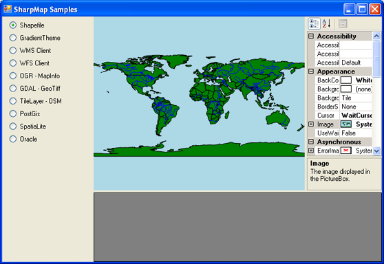
By default, the Shapefile opens in the right pane with the map .
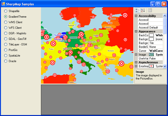
Similarly, view the item Gradiet Theme.
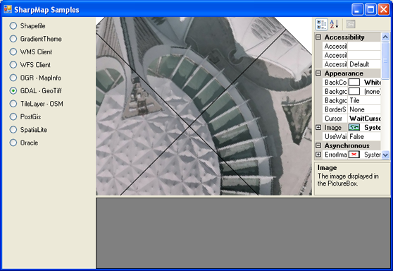
When trying to output files in the format “MapInfo” (vector) and “GeoTiff” (raster), an error occurs because the corresponding GDAL / OGR libraries are not connected . To connect them, you need to download the set of FWTools libraries and install.
Then in the Trunk \ WinFormSamples directory, open the file “app.config” and in the appSettings block we change all the paths to the path to the FWTools folder and its subdirectories (if required).
Recompile the Build -> Rebuild Solution project. We start.
After the done manipulations, it becomes possible to open many vector and raster formats and work with them.

On this I want to end. More information about SharpMap, as well as documentation and a forum on the project website:
SharpMap v1.0
SharpMap v2.0
Thank you for your attention!
In my opinion, the topic of working with spatial data, and in particular with GIS systems, is poorly covered on Habré. As a result, I would like to devote my first article to a wonderful tool called SharpMap . Moreover, the object of consideration is quite interesting from the point of view of developing GIS applications, and there is little information in Russian about its use. The search returns only a few results in forums devoted to programming topics.
Introduction
The following definition is given on the project’s official website:
SharpMap is an easy-to-use mapping library for use in desktop and web applications. The engine is written in C # and is based on the .NET 2.0 framework. Distributed under the GNU Lesser General Public License .
Opportunities
Currently, two versions of the engine are being developed, differing in their capabilities.
| Opportunities | SharpMap v1.0 | SharpMap v2.0 |
|---|---|---|
| Using .NET programming languages (C #, VB.NET etc.) | + | + |
| Representation of attributes as labels | + | Beta 2 |
| Support for points, lines, polygons, multipolygons, multi-points, etc. according to the OpenGIS specification | + | + |
| Zooming and moving around the map | + | + |
| Extended Themed Maps | + | + |
| Change projection "on the fly" | + | + |
| Layered spatial indexing | - | + |
| Ability to select and highlight geometries | - | + |
| Spatial analysis and geometry processing | - | + |
| Ability to replace geometries, spatial indexes, and projection libraries | - | + |
| For WEB | SharpMap v1.0 | SharpMap v2.0 |
| Http Handler for creating images | + | not finished |
| AJAX - control | + | not finished |
| Use as a WMS 1.3.0 server | + | not finished |
Extensions
By default, SharpMap only works with the vector format of Shape files, however, due to extensions, the number of supported formats can be increased.
| Expansion | Description |
|---|---|
| OGR Povider | A library that adds support for many vector data formats |
| GDAL Raster Layer | Adding support for multiple raster formats |
| Postgis | PostgreSQL / PostGIS Provider |
| Oracle | Oracle Spatial Information Provider |
| NetTopologySuite Data Provider | Adds NTS functionality |
| Simple chart | Adds attribute-based charts to the map |
| Spatialline | SQLite / SpatialLite Provider |
The GDAL / OGR library , which has also not yet been covered on Habré, deserves a separate review and a separate article.
In action
At first glance, the implementation of the application using SharpMap and, in particular, the inclusion of the GDAL / OGR library did not seem quite obvious. I had to look through a lot of English-language forums to figure out what's what.
An example will be given for SharpMap v.1.0 in the Visual Studio 2008 development environment.
So, for starters, download the ChangeSet project. At the time of writing, version No. 74794 is relevant.
Unpack.
To demonstrate the capabilities of the engine, it is proposed to run the SharpMap.VS2008.sln project file in the Trunk folder. In SolutionExplorer install the WinFormSamples project as StartUp Project.
The right pane of the form shows the RadioButton set with the corresponding file types. All test geo-data files are stored in the directory:Trunk \ WinFormSamples \ bin \ Debug \ GeoData .
By default, the Shapefile opens in the right pane with the map .
Similarly, view the item Gradiet Theme.
When trying to output files in the format “MapInfo” (vector) and “GeoTiff” (raster), an error occurs because the corresponding GDAL / OGR libraries are not connected . To connect them, you need to download the set of FWTools libraries and install.
Then in the Trunk \ WinFormSamples directory, open the file “app.config” and in the appSettings block we change all the paths to the path to the FWTools folder and its subdirectories (if required).
Recompile the Build -> Rebuild Solution project. We start.
After the done manipulations, it becomes possible to open many vector and raster formats and work with them.
On this I want to end. More information about SharpMap, as well as documentation and a forum on the project website:
SharpMap v1.0
SharpMap v2.0
Thank you for your attention!