July 25, 2013 at 08:09
Comparison of two GPS Data Loggers
Many of us love hiking. We bring tons of photos, then we poke around in the long evenings, trying to choose the best ones, so that we have something to show to friends and acquaintances. But some of this is not enough. Sometimes you want to immerse yourself in memories a little more completely. That would be to record the route and then see it on the map or in Google Globes!
The first thing that comes to mind is the navigator. We will not touch on a specific implementation, it can be a specialized device or an application on a smartphone. However, every hiker knows: the batteries run out at the most inopportune moment (and more serious ones, breaking off the handle on the toothbrush, will also remember the weight of the backpack). And it’s not always possible to change or charge these same batteries. Yes, and the availability of a card is not always necessary, I just want to know the path traveled.
In our last horse trip, a friend had a Gramin Oregon 450 navigator, on which we wrote a track. Analyzing the track turned out to be a very exciting experience! You can look at the speed of movement, and then remember where you trotted, where you galloped, and where you trailed along, where you watered the horses and where the parking was done. And if you take into account that you can “attach” photos to this data and even make a beautiful .kmz file with marks and photos! .. In general, there is room for imagination.
From now on, it was decided to “write” all the campaigns, and I proceeded to search for a device.
To begin with, I determined the criteria for the necessary device:
- maximum compactness;
- only logging, no navigation;
- maximum battery life;
- setting the POI point with the button (if possible, but necessary).
The global Ebay market and the electronic Cherkizon AliExpress were searched. At DealExtreme, I didn’t even climb, because I want a reliable device, preferably from a well-known manufacturer. On Ebay, tracking devices for cars / children / pets dominate with the ability to obtain the current location of the object via a GSM channel. AliExpress “promotes” DVRs. However, devices from the final set that I came to can be found both here and there. But the most complete "catalogs" with more or less sane descriptions are located here and here .
Oddly enough, there is not enough sensible information on such devices, although it turned out that the idea of linking photographs to the coordinates of the shooting location was very attractive. The network is full of descriptions of similar services, even on Habré this issue was discussed. But I almost did not find a detailed review of the functionality of the glands.
In general, after a long digging on the websites of manufacturers, on Youtube in particular, and the Internet in general, I personally chose the following devices:
1. Holux M-241c
2. Holux M-1200E
3. GiSTEQ PhotoTrackr Mini (DPL900)
4. Columbus V -990
Number 1 “dropped out of the fight” for a very prosaic reason: there is nowhere to buy. There is a model without the “c” index, with the transfer of coordinates via Bluetooth, but I don’t need it at all, it only eats up the battery life, and I read the rumors that the quality of the devices has recently become completely different and many complain about big errors in determining the location . In addition, how many I did not look for, but still did not understand whether it is possible to put a POI on this device. Well, the MTK chip (MediaTek) of the first generation, according to reviews, is rather slow and gluttonous in terms of power supply (at least compared to the chips of the second generation).
Very sorry! After all, it’s a wonderful toy, judge for yourself: it works from an AA battery, there is a display indicating the time received from the satellite (one picture and you know the time offset of your camera relative to Logger).
Number 2, too, could not be found for sale (I repeat, I searched in “decent” stores with courier delivery).
Number 3 on the official website is no longer for sale. We managed to find its upgraded version on the more modern SiRF Atlas IV chip - Canmore GT-730FL-S .
In the end, two devices were purchased: Columbus V-990 and Canmore GT-730FL-S, which was much helped by this comparison table of GPS chips.
Columbus V-990:
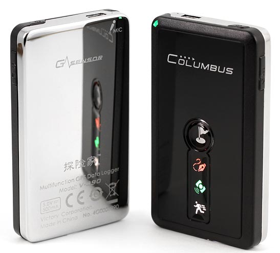
The device is definitely beautiful. The back polished metal surface and velvet case make it look like a lighter. Charging takes place using the mini-USB connector. And, alas, its only purpose is to obtain data on it is impossible (although the D + and D- contacts leave the connector somewhere). The “heart” of the device is the PIC microcontroller of the 18th series.
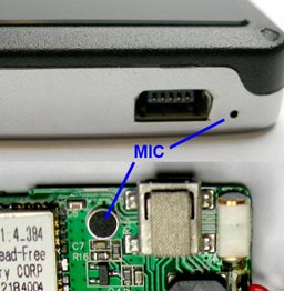
The pluses include the second-generation MediaTek GPS chip (MTK 3329), capable of working with 66 satellites (?!), A motion sensor (which disables track recording at rest), a 1000 mAh battery, and more put tags, but also make voice prompts to them, as well as the ability to install a memory card up to 2 GB, which gives us just an incredible amount of space for recording tracks. True, the device does not work without a memory card, or rather it works, but there is nowhere to write a track. And disassembling the device, we will see that the terrifying quality of recording voice tags is due to the fact that the hole in the case and the microphone on the board are far apart, like “A” from “I”:
By the way, the device can be transferred to the so-called “Spy mode”, in this mode the device wakes up after a certain period of time (set in the settings), saves its coordinates and again safely “falls asleep” until the next time. True, I myself did not check this mode, since there was no interest.
Of the minuses, the following should be noted:
- the indication “fades” in daylight, becoming almost unreadable;
- a separate button is used to set a POI point with a voice tag, it is rather small, located on the side and with a small stroke;
- when recording a voice tag, setting a point in the log occurs after releasing the button (that is, at the end of the recording), this is not essential when walking, but if you move fast, then during this time you can be far from the place necessary for marking;
- if you hold the POI setup button longer than necessary, recording of a new track will begin.
Canmore GT-730FL-S:

Externally, this logger looks like a thick flash drive. Case material - plastic. In general, everything is pretty decent, except that there is no such gloss as that of Columbus. The device charges via USB, connecting like a regular USB flash drive. The manufacturer indicates a battery capacity of 450 mA / h.
SiRF Atlas IV chip works with satellites; support for 48 satellites (GPS and Galileo) is announced.
To extract the data, you must install the virtual COM port driver, which emulates the STM32 microcontroller, which is also the “heart” of this device. Data (tracks) is extracted either by the program from the manufacturer ( CanWay ), or by the program from the “original” (GiSTEQ PhotoTrackr Mini (DPL900)) - PhotoTrackr . However, gpsbabel also reads something , but I did not find the exact launch parameters (and I didn’t really look for it, to be honest).
Let me give you some photos of the insides
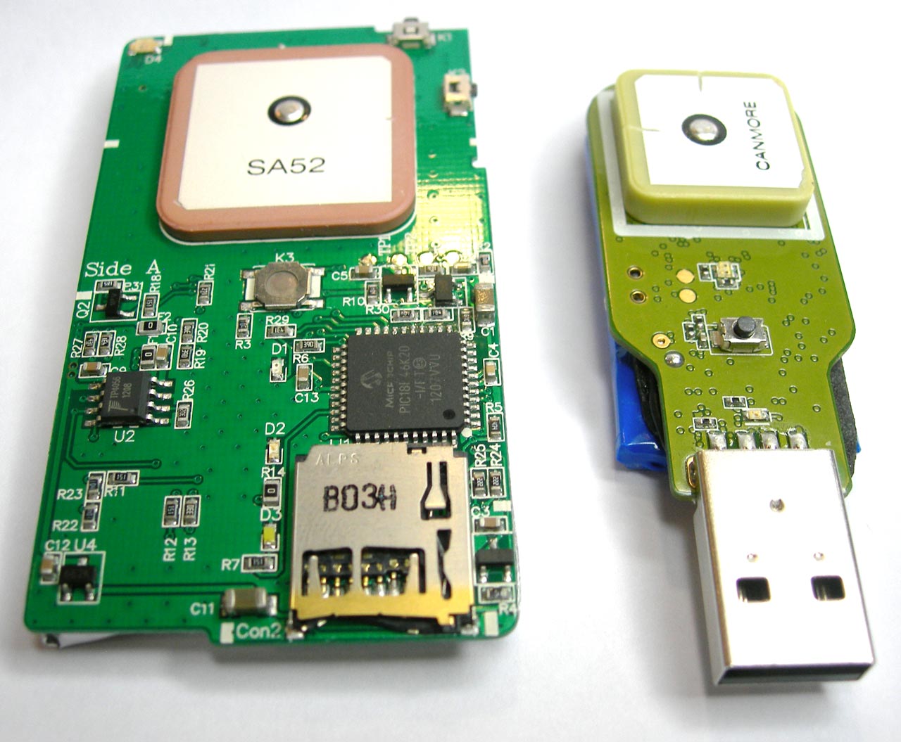
As you can see, the patch antenna at Columbus is slightly larger in size than its competitor. Perhaps this is due to the fact that MediaTek has a GPS chip combined with an antenna, while SiRF has two separate devices. However, I could be wrong, and if so, then correct me in the comments.

An inquisitive eye will notice that the contacts D + and D- of the mini-USB connector are somewhere apart, but, unfortunately, there is no practical sense anyway.

The bottom left corner of the photo, a square of ~ 5 mm, is the SiRF Atlas IV GPS chip.
And a couple of photos for size estimation:
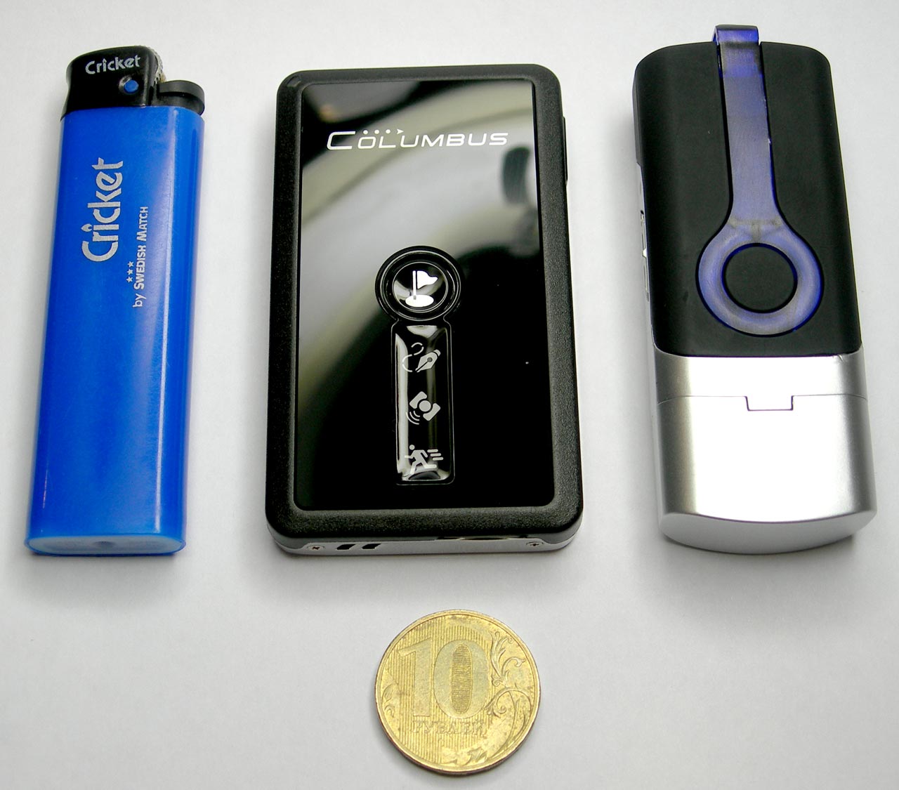
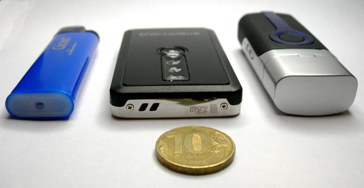
Now let's talk about the practical side of use and immediately in a comparative manner.
Columbus catches satellites in 40 seconds, Canmore - about three to five minutes. Columbus more confidently "holds the track", but sometimes it has problems with incorrect determination of altitude (peaks up, mainly at the time of establishing a connection with the satellite). Both devices are not without problems with the appearance of “abnormal” points (a sharp surge to the side), however, infrequent and impressions in general do not spoil. There is a difference in determining heights between these two devices:
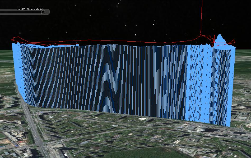
Blue is Canmore, red is Columbus. There is a noticeable difference in determining the height and height jumps of the MTKII chip.
Unfortunately, I can not say more about the device Canmore GT-730FL-S. I got a device with a marriage (the battery does not charge), therefore I use only the data that I managed to accumulate.
The Canmore POIs are set at the time of pressing, confirmation is a triple blinking LED, there is no sound. Columbus is better in this regard, as there is sound confirmation.
Columbus voice tags have disgusting quality (the reason I mentioned above). The batteries in the mode of periodic recording of tracks last for a long time, and it is unlikely that someone will need to write a track without stopping for more than 5-6 hours. Unless in a road trip, but there is electricity at hand.
The moment of receiving data from the device is important. Columbus writes the track to a .csv file on a memory card, and adds voice tags (.wav files) there too. It is easily converted, and there are enough ready-made solutions .
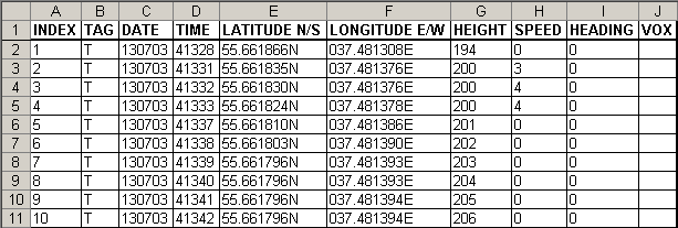
TAG column: T - regular point, C - POI, V - voice tag (VOX column - file name with voice tag, without extension).
Reading data from the card and converting it is not difficult in almost any modern OS, and this is another huge plus for Columbus.
Since I am a Windup, I did not have problems installing the driver and reading data from Canmore, but I don’t know how to be adherents of other OSs. If you know, then write in the comments. I am sure that a solution will come in handy for many.
That seems to be all. In general, I liked both devices but none of them impressed as ideal.
For those interested, I post two demo tracks and an example of a Columbus voice tag, one from each device. I adjusted the tracks a little (cut off the excess) so that they start and end at the same time. I got out of the subway (with working loggers in a shoulder bag), reached the bus stop, waited for the bus, got to work, got out and walked to the checkpoint. I think that on these tracks everyone will be able to evaluate for themselves the work of a GPS chip.
PS If you will, then I would describe my vision of an ideal camp logger :
- work from one battery of the standard size "AA" or from one or two batteries of the standard size "AAA";
- the ability to install a micro-SD memory card;
- the presence of a conveniently located POI button, setting a point on the track by simply pressing it, confirmation with a sound signal;
- the presence of an LCD screen with the number of satellites currently being received, the current time (to synchronize the time shift in the camera) and the battery level (4-5 segments are enough);
- GPS chip MTK 3329 or more modern, preferably with GLONASS support.
- IPX7 waterproof;
If you know a device that combines all these characteristics, then let me know immediately!