What's in my crater for you?
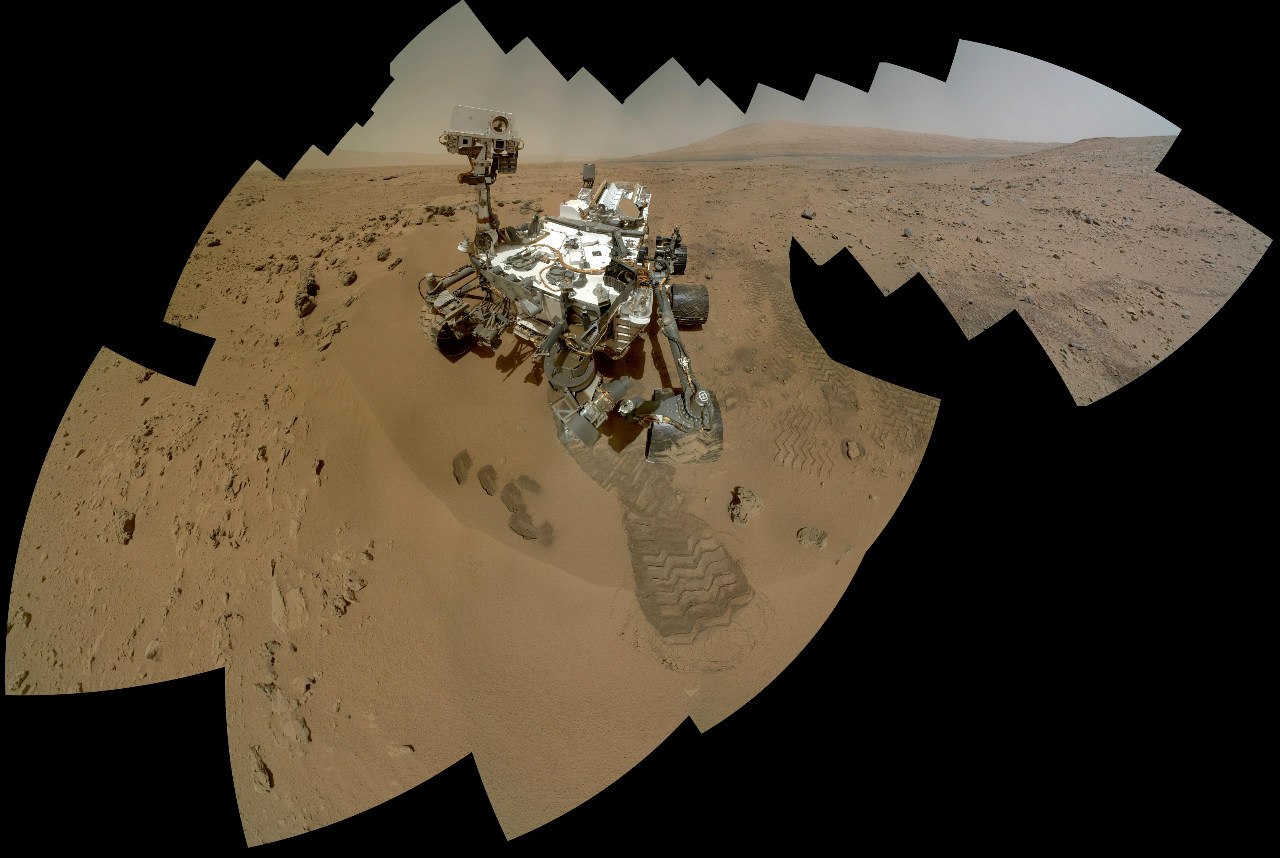
As promised, I publish material about the place that is currently exploring the Curiosity rover. Gale Crater and Mount Sharpe (Aeolide), according to NASA - the most promising objects for research on the surface of Mars. From there we can get the richest scientific information that such a perfect robot geologist as Curiosity is able to collect.
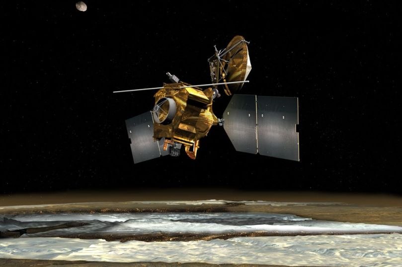
In order to choose a good place for research on Mars, it was necessary to properly study the planet remotely - from orbit. To do this, in 2005, the Mars Reconnaissance Orbiter was launched - an outstanding device worthy of its land follower. This satellite is actually a telescope facing down, which has several cameras that allow you to shoot the surface of Mars with detail up to 25 cm per pixel. It rotates in a circular orbit at an altitude of 300-275 km above the planet and constantly scans the surface with its optical instruments.
Through the efforts of MRO and its predecessors, several sites have been identified that are of the greatest interest for research and promise interesting discoveries. Almost all of them are associated with the activity of water on the surface of Mars, and only Gale Crater with a mountain in the center is a more complex formation.
Mount Sharpe or officially “Eolida” is interesting at least because the scientists of the whole world are simply not able to understand how it was formed. In addition to this riddle, Eolida is primarily attractive to scientists for its structure. Its layered structure is a unique exposure, which is convenient for research by available technical means. These factors determined the decision of NASA geologists, who, after active discussion, chose Gale Crater as the target for MSL Curiosity.
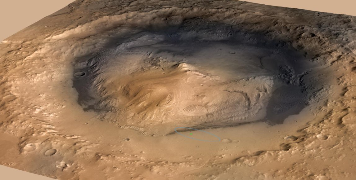
Gale Crater is a very ancient geological feature on the surface of Mars. According to today's estimates, it is 3.5-3.8 billion years old. That is, it captures the oldest - Noachian period of the Martian geological history known to date. The first 100 thousand years of the crater existed at a time when the conditions on Mars were very similar to the conditions of the Earth at the time of the origin of the first life. It arose after the fall of a huge asteroid with a diameter of several kilometers. The impact resulted in a 150-kilometer crater. The power of the explosion is comparable to the blow that 65 million years ago destroyed dinosaurs on Earth. Despite the scale of the impact, this crater is far from the largest on Mars. There are dozens like him, and the record holders: Hellas, Argir, Isidis, are ten times or more superior to Gail.
A feature of the formation of the Gale Crater is a high central uplift. Such peaks are not uncommon in craters of this magnitude. Upon impact, the planetary crust behaves almost the same as the surface of a liquid when a drop falls, and the appearance of a central peak depends on the structure of the crust and the amount of energy released during the impact - the mountain will freeze or creep, leaving the bottom of the crater flat.

The difference between Mount Sharpe and other Martian craters is that it did not remain alone, but began to collect a sedimentary "skirt" around itself - layer by layer spreading to the sides to the edge of the crater, but deposits did not fill the crater to the very edges, leaving it deep bottom.
After Gale Crater caught the attention of NASA, it was even more closely examined from orbit. The studies were carried out both in the optical range - the HiRise MRO camera, and in the infrared. An analysis by the THEMIS camera of the Mars Odyssey satellite made it possible to determine geological differences in the structure of the soil, which looks uniform for the ordinary human eye.
THEMIS allows you to determine the differences in the Martian rock through the study of thermal inertia. In simple terms, the camera sees how quickly the surface cools after heating and how quickly it heats after cooling. Depending on its geological structure, the surface behaves differently: the sand heats up quickly and cools quickly, the stone accumulates thermal energy for a long time and gives it away for a long time during the night. To determine the difference in heating-cooling, the survey was carried out in day and night mode.
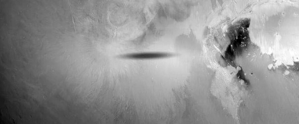
A similar device was installed on the Soviet apparatus "Phobos-2". Studying the behavior of Martian soil under the shadow of Phobos, he managed to generate a domestic ufological legend about the “spindle-shaped UFO” and “inverse trace” on Mars. Although he just took off the soil cooled in the shadow of Phobos with an infrared camera. Unfortunately, he worked for only a couple of months, and Mars Odyssey has been working for almost a decade, and after the recent “brain transplant” - the transition to a backup computer - he is ready to work the same amount.
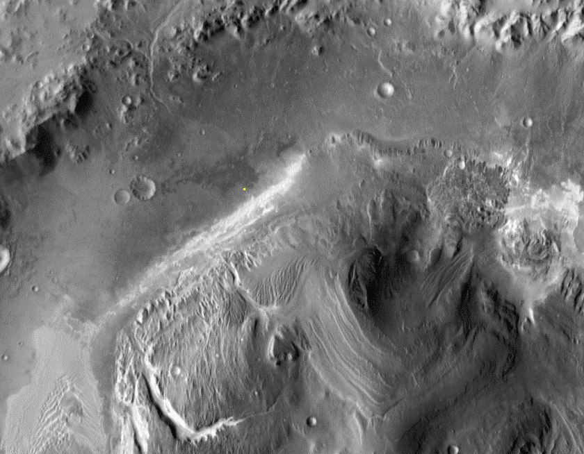
A study by HiRise and THEMIS identified a landing point in Gale Crater itself. Studying Sharpe Mountain in detail, scientists discovered two deep canyons that cut through the thickness of the mountain and created a convenient area for exploring its internal structure. Not far from one of them, thermal imaging identified yet another interesting surface area of Aeolide Palls - the Aeolide Plains. A stream of water from the north-west eroded the annular shaft of the crater and carried fan alluvial rocks to the plain. This fan has different soil characteristics with low and high thermal inertia, that is, one part is loose, the second is very dense.
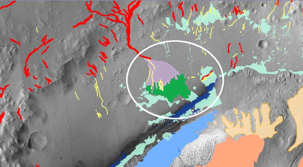
(Violet - loose deposits, green - solid. Red - canyon and channels. Curiosity location is indicated by a white cross)
In addition, on the plain there are relief features that are quite common for Mars, which are found not only in Gale Crater, but they have not yet been studied by land means. We are talking about inverted channels "inverted channels" (marked in yellow on the diagram).
It is believed that these are river channels in which the soil has changed its structure and turned out to be stronger than the surrounding surface, which was destroyed by wind erosion. That is, the wind lifted the banks of the rivers below their bottom, but the bottom sediments were more resistant to weathering. An alternative theory of their formation suggests that inverted channels occurred when river flows carried into stagnant water bodies. Streams slowed down and sand, which carried water, sank to the bottom of lakes and seas. Similarly, river deltas form on Earth, and also formed on Mars, but there is no unity of opinion about the emergence of inverted channels. Curiosity's working tools can help to figure this out, but the rover has landed far from these “channels” and is unlikely to make a detour for several kilometers for them.
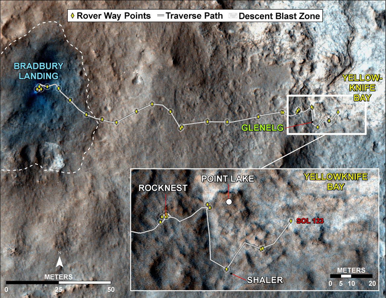
Where the Mars rover landed, the most attention of scientists was focused on a site with three types of soil.
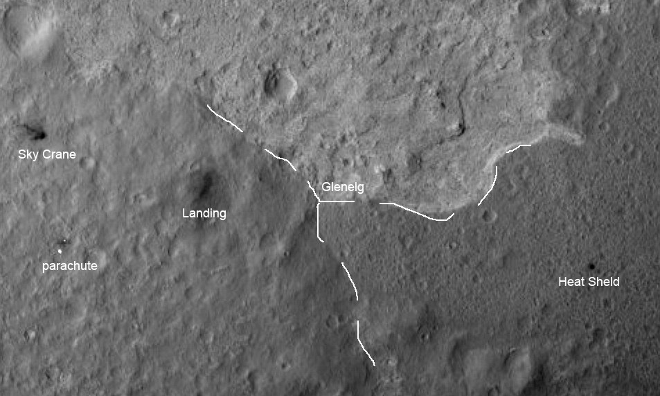
The place named Glenelg was Curiosity's first major goal, which even forced him to deviate slightly from the original route. At this point, three types of surfaces converge: a drift cone with low thermal inertia; the area that NASA designates as HTI - high thermal inertia - with high thermal inertia; and an older site densely strewn with craters.
The study of the first type of soil took place on the way to Glenegle. It was here that rounded pebbles were discovered, which indicated the effect of a stream of water.
The geologists are much more interested in the HTI breed. Now this is the main mystery Curiosity is going to deal with. Logically, high thermal inertia is characteristic of rock, but this type of surface is located only in one place of the Gale crater - in the cone of removal from the blurred wall of the crater. The original version of geologists was that this rock was washed away by water and cemented when the stream dried. The view from outer space suggested that such a scenario is quite plausible - the surface looks like the bottom of a dried-up lake that has cracked. However, the rover looked at this place from below, and there is less hope that this surface is like dried silt.

Formats are more VK
After Curiosity came out of the removal cone to Glenelg, more and more of his camera began to fix stones resembling volcanic rocks, and rounded pebbles almost completely disappeared. At first, individual stones indicated their volcanic origin. The very first proven volcanic cobblestone is Jake Matievich.
Then their number began to grow.
Finally, when some layers began to resemble whole frozen lava flows, I realized that it was time to look for the volcano.
The closest known volcano is in the Elysium Highlands, 1200 km from Gale Crater. Some stones could somehow be imagined arriving during powerful eruptions. On the Land of Krakatoathrowing stones for hundreds of kilometers, and due to low attraction on Mars, the range could increase several times. But it is impossible to throw the lava river so far, especially since it must still overcome the annular shaft of the crater. The obvious conclusion was obvious: somewhere nearby there was a volcano. Moreover, the probability that Mount Sharpe is a volcano is practically zero. From the satellite there are no signs of volcanic activity on the mountain itself. NASA does not mention anything about the volcano.
I had to arm myself with stereo glasses and go on a journey through an anaglyphic image of the crater and its environs.
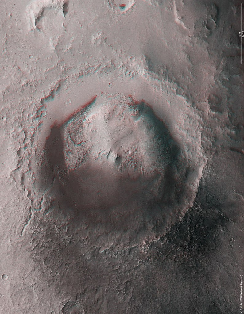
(NASA invites all owners of red-blue glasses to plunge into the world of Martian 3D-anaglyphs)
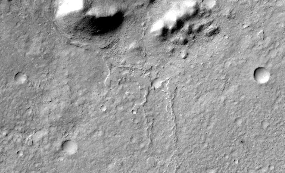
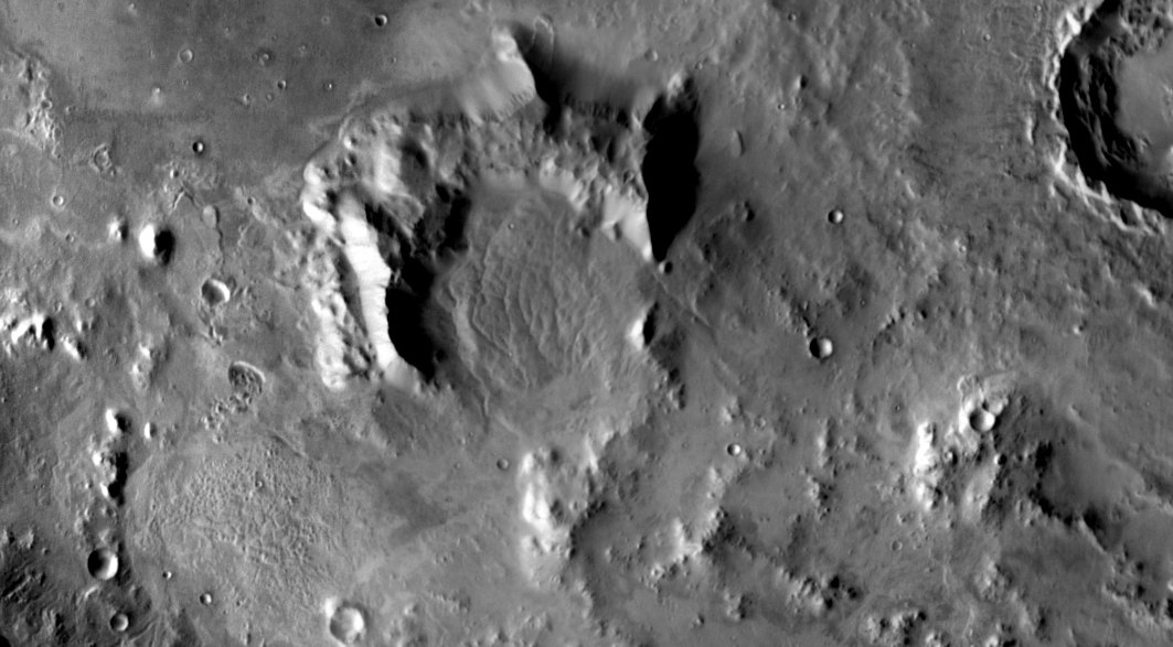
And the volcano was found quite quickly. More precisely, a mountain that can be interpreted as a volcano. A crescent-shaped elevation can be found northwest of the landing site. Just where the stream of water flowed from, cutting through the crater shaft and carrying rock flows to the plain.
The assumption that this mountain is a volcano explains many observations. Firstly, a river bed could form when eruptions melted glaciers that could lie at the foot of the volcano. Secondly, all these pieces of pumice, volcanic tuff and lava flows around the rover are explained. Thirdly, it was lava that could turn out to be that solid rock with a high degree of thermal inertia. True, if we compare the map of thermal inertia of the rocks with the current location of the rover, it is clear that he has not reached HTI yet, and lavas around him are already entire layers. So finally the riddle is not solved.

(Red dots - the route of the rover)
NASA, it seems, does not even guess about this volcano, at least there is not a single mention of it in scientific documentation, describing the landing site, and there is not a single frame of this place with the high-resolution camera HiRise of the MRO satellite, which the Gail crater itself and the riverbed were studied very closely.
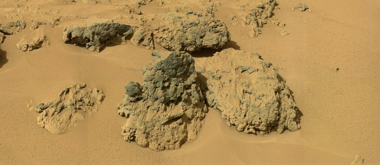
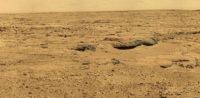
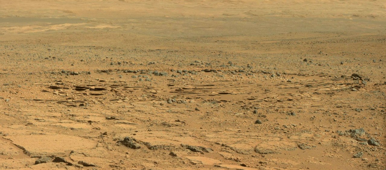
But there are enough other puzzles in the crater. Two months ago, when Curiosity climbed into its rock nest (Rocknest) and spent 40 days in it, a very interesting area came into the lenses of its cameras.
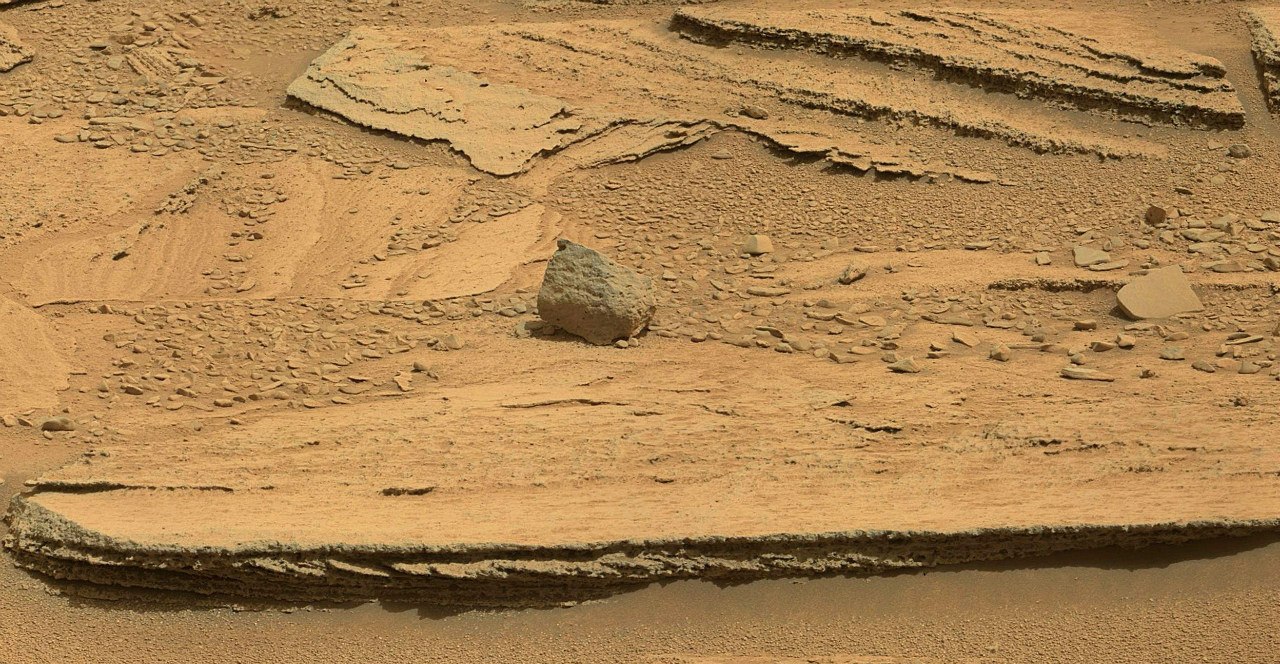
These layers, called Shaler, are located just on the border of the two surface types and can reveal details of the origin of the oldest site of Glenelg. Typically, such sandstone layers are formed by seasonal exposure to water. Moreover, strictly horizontal layers - at the bottom of reservoirs, and oblique - in the coastal zone - actually on the beaches.
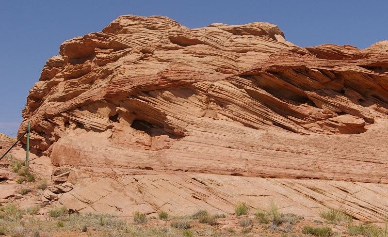
Here, for example, Arizona sandstone:
But the material of these Martian layers is not yet known, therefore, its other origin is also possible. The fact is that the rover is now purposefully moving to Point Lake, where it is planned to conduct the first drilling operations on Mars.
In his movement, he is only slightly distracted by interesting objects. Perhaps the Curiosity team expects to return on the same route, so even avoids such attractive places as Shaler.
But the place is amazing. The name given in honor of the American paleontologist hints at this. Apparently, NASA is waiting for something interesting there.
I look forward to when they return to exploring these layers.

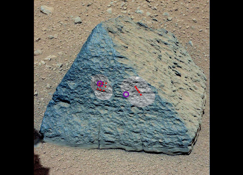
As they descended into the lowland called Yellowknifle Bay, strange “bubbles” began to fall under the wheels of the rover.
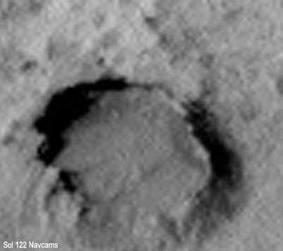
This is another mystery that NASA, apparently, has postponed until later, since during the entire run they received almost no attention. Only one of them was shot with a color camera, and it seems that not even a single one was fired at by the Chem Cam to find out the chemical composition. That these "bubbles" can only be speculated. If there is lava under the wheels, then these may be traces of fallen stones that fell into a thickening stream and left such dents. If it is sandstone or other ancient deposits, then glandular nodules can form in this way.
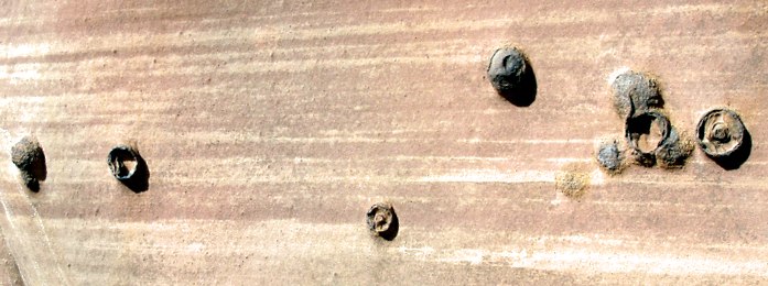
(This is a photo from Earth)
Given the recent hype surrounding the discovery-undetection of organics in Martian soil, we need to tell you when to expect a sensation. Volcanic rocks are not rich in organic matter even on Earth, especially organic organisms of biological origin cannot be there. Biological organic matter is poorly preserved in alluvial deposits. The greatest hopes of NASA astrobiologists, and of the whole world, are associated with one thin layer found in Gale Crater - phyllosilicates or smectites.
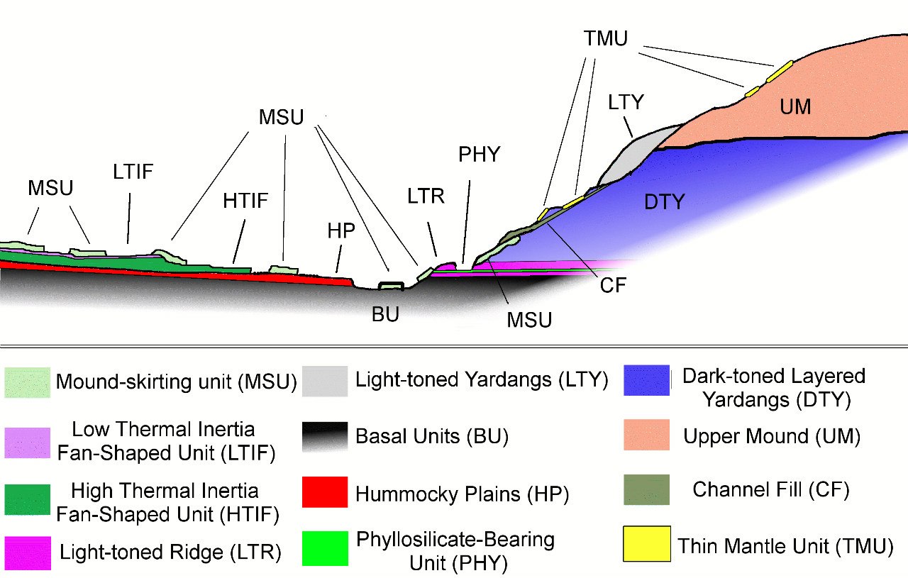
Almost only for their sake they equipped the SAM device, capable of detecting organic matter of biological origin. Phyllosilicates are an ancient clay formed by water that eroded volcanic deposits in Noah time. Such a breed is widespread on Earth and very rare on Mars. The peculiarity of its formation is that water during this period was favorable for life, that is, it did not contain a large amount of sulfates and perchlorates, which poisoned it in the next geological era of the Hesperides.

Sulfates already go above this layer, that is, climbing Mount Sharp, from the point of view of astrobiology, is no longer as interesting as exploring the foot. But by examining these smectites, Curiosity will be able to give an almost final answer to the sacramental question - was there life on Mars or not. But he will not get to them soon.

If the rover will move along a previously planned route, then it will take him about eight kilometers to reach the phyllosilicates. In the meantime, he overcame about 500 meters, and almost in the opposite direction. After geologists form a general idea of the structure of the plain, the movement of the rover will accelerate, but we still have to wait at least 8-10 months to arrive at the foot of Mount Sharp.

(Address to reposters: I don’t care about copyright, but don’t kill outgoing links; if I brought them, I think that they are needed. Thank you.)
In order to choose a good place for research on Mars, it was necessary to properly study the planet remotely - from orbit. To do this, in 2005, the Mars Reconnaissance Orbiter was launched - an outstanding device worthy of its land follower. This satellite is actually a telescope facing down, which has several cameras that allow you to shoot the surface of Mars with detail up to 25 cm per pixel. It rotates in a circular orbit at an altitude of 300-275 km above the planet and constantly scans the surface with its optical instruments.
Through the efforts of MRO and its predecessors, several sites have been identified that are of the greatest interest for research and promise interesting discoveries. Almost all of them are associated with the activity of water on the surface of Mars, and only Gale Crater with a mountain in the center is a more complex formation.
Mount Sharpe or officially “Eolida” is interesting at least because the scientists of the whole world are simply not able to understand how it was formed. In addition to this riddle, Eolida is primarily attractive to scientists for its structure. Its layered structure is a unique exposure, which is convenient for research by available technical means. These factors determined the decision of NASA geologists, who, after active discussion, chose Gale Crater as the target for MSL Curiosity.
Gale Crater is a very ancient geological feature on the surface of Mars. According to today's estimates, it is 3.5-3.8 billion years old. That is, it captures the oldest - Noachian period of the Martian geological history known to date. The first 100 thousand years of the crater existed at a time when the conditions on Mars were very similar to the conditions of the Earth at the time of the origin of the first life. It arose after the fall of a huge asteroid with a diameter of several kilometers. The impact resulted in a 150-kilometer crater. The power of the explosion is comparable to the blow that 65 million years ago destroyed dinosaurs on Earth. Despite the scale of the impact, this crater is far from the largest on Mars. There are dozens like him, and the record holders: Hellas, Argir, Isidis, are ten times or more superior to Gail.
A feature of the formation of the Gale Crater is a high central uplift. Such peaks are not uncommon in craters of this magnitude. Upon impact, the planetary crust behaves almost the same as the surface of a liquid when a drop falls, and the appearance of a central peak depends on the structure of the crust and the amount of energy released during the impact - the mountain will freeze or creep, leaving the bottom of the crater flat.
The difference between Mount Sharpe and other Martian craters is that it did not remain alone, but began to collect a sedimentary "skirt" around itself - layer by layer spreading to the sides to the edge of the crater, but deposits did not fill the crater to the very edges, leaving it deep bottom.
After Gale Crater caught the attention of NASA, it was even more closely examined from orbit. The studies were carried out both in the optical range - the HiRise MRO camera, and in the infrared. An analysis by the THEMIS camera of the Mars Odyssey satellite made it possible to determine geological differences in the structure of the soil, which looks uniform for the ordinary human eye.
THEMIS allows you to determine the differences in the Martian rock through the study of thermal inertia. In simple terms, the camera sees how quickly the surface cools after heating and how quickly it heats after cooling. Depending on its geological structure, the surface behaves differently: the sand heats up quickly and cools quickly, the stone accumulates thermal energy for a long time and gives it away for a long time during the night. To determine the difference in heating-cooling, the survey was carried out in day and night mode.
A similar device was installed on the Soviet apparatus "Phobos-2". Studying the behavior of Martian soil under the shadow of Phobos, he managed to generate a domestic ufological legend about the “spindle-shaped UFO” and “inverse trace” on Mars. Although he just took off the soil cooled in the shadow of Phobos with an infrared camera. Unfortunately, he worked for only a couple of months, and Mars Odyssey has been working for almost a decade, and after the recent “brain transplant” - the transition to a backup computer - he is ready to work the same amount.
A study by HiRise and THEMIS identified a landing point in Gale Crater itself. Studying Sharpe Mountain in detail, scientists discovered two deep canyons that cut through the thickness of the mountain and created a convenient area for exploring its internal structure. Not far from one of them, thermal imaging identified yet another interesting surface area of Aeolide Palls - the Aeolide Plains. A stream of water from the north-west eroded the annular shaft of the crater and carried fan alluvial rocks to the plain. This fan has different soil characteristics with low and high thermal inertia, that is, one part is loose, the second is very dense.
(Violet - loose deposits, green - solid. Red - canyon and channels. Curiosity location is indicated by a white cross)
In addition, on the plain there are relief features that are quite common for Mars, which are found not only in Gale Crater, but they have not yet been studied by land means. We are talking about inverted channels "inverted channels" (marked in yellow on the diagram).
It is believed that these are river channels in which the soil has changed its structure and turned out to be stronger than the surrounding surface, which was destroyed by wind erosion. That is, the wind lifted the banks of the rivers below their bottom, but the bottom sediments were more resistant to weathering. An alternative theory of their formation suggests that inverted channels occurred when river flows carried into stagnant water bodies. Streams slowed down and sand, which carried water, sank to the bottom of lakes and seas. Similarly, river deltas form on Earth, and also formed on Mars, but there is no unity of opinion about the emergence of inverted channels. Curiosity's working tools can help to figure this out, but the rover has landed far from these “channels” and is unlikely to make a detour for several kilometers for them.
Where the Mars rover landed, the most attention of scientists was focused on a site with three types of soil.
The place named Glenelg was Curiosity's first major goal, which even forced him to deviate slightly from the original route. At this point, three types of surfaces converge: a drift cone with low thermal inertia; the area that NASA designates as HTI - high thermal inertia - with high thermal inertia; and an older site densely strewn with craters.
The study of the first type of soil took place on the way to Glenegle. It was here that rounded pebbles were discovered, which indicated the effect of a stream of water.
The geologists are much more interested in the HTI breed. Now this is the main mystery Curiosity is going to deal with. Logically, high thermal inertia is characteristic of rock, but this type of surface is located only in one place of the Gale crater - in the cone of removal from the blurred wall of the crater. The original version of geologists was that this rock was washed away by water and cemented when the stream dried. The view from outer space suggested that such a scenario is quite plausible - the surface looks like the bottom of a dried-up lake that has cracked. However, the rover looked at this place from below, and there is less hope that this surface is like dried silt.
Formats are more VK
After Curiosity came out of the removal cone to Glenelg, more and more of his camera began to fix stones resembling volcanic rocks, and rounded pebbles almost completely disappeared. At first, individual stones indicated their volcanic origin. The very first proven volcanic cobblestone is Jake Matievich.
Then their number began to grow.
Finally, when some layers began to resemble whole frozen lava flows, I realized that it was time to look for the volcano.
The closest known volcano is in the Elysium Highlands, 1200 km from Gale Crater. Some stones could somehow be imagined arriving during powerful eruptions. On the Land of Krakatoathrowing stones for hundreds of kilometers, and due to low attraction on Mars, the range could increase several times. But it is impossible to throw the lava river so far, especially since it must still overcome the annular shaft of the crater. The obvious conclusion was obvious: somewhere nearby there was a volcano. Moreover, the probability that Mount Sharpe is a volcano is practically zero. From the satellite there are no signs of volcanic activity on the mountain itself. NASA does not mention anything about the volcano.
I had to arm myself with stereo glasses and go on a journey through an anaglyphic image of the crater and its environs.
(NASA invites all owners of red-blue glasses to plunge into the world of Martian 3D-anaglyphs)
And the volcano was found quite quickly. More precisely, a mountain that can be interpreted as a volcano. A crescent-shaped elevation can be found northwest of the landing site. Just where the stream of water flowed from, cutting through the crater shaft and carrying rock flows to the plain.
The assumption that this mountain is a volcano explains many observations. Firstly, a river bed could form when eruptions melted glaciers that could lie at the foot of the volcano. Secondly, all these pieces of pumice, volcanic tuff and lava flows around the rover are explained. Thirdly, it was lava that could turn out to be that solid rock with a high degree of thermal inertia. True, if we compare the map of thermal inertia of the rocks with the current location of the rover, it is clear that he has not reached HTI yet, and lavas around him are already entire layers. So finally the riddle is not solved.
(Red dots - the route of the rover)
NASA, it seems, does not even guess about this volcano, at least there is not a single mention of it in scientific documentation, describing the landing site, and there is not a single frame of this place with the high-resolution camera HiRise of the MRO satellite, which the Gail crater itself and the riverbed were studied very closely.
But there are enough other puzzles in the crater. Two months ago, when Curiosity climbed into its rock nest (Rocknest) and spent 40 days in it, a very interesting area came into the lenses of its cameras.
These layers, called Shaler, are located just on the border of the two surface types and can reveal details of the origin of the oldest site of Glenelg. Typically, such sandstone layers are formed by seasonal exposure to water. Moreover, strictly horizontal layers - at the bottom of reservoirs, and oblique - in the coastal zone - actually on the beaches.
Here, for example, Arizona sandstone:
But the material of these Martian layers is not yet known, therefore, its other origin is also possible. The fact is that the rover is now purposefully moving to Point Lake, where it is planned to conduct the first drilling operations on Mars.
In his movement, he is only slightly distracted by interesting objects. Perhaps the Curiosity team expects to return on the same route, so even avoids such attractive places as Shaler.
But the place is amazing. The name given in honor of the American paleontologist hints at this. Apparently, NASA is waiting for something interesting there.
I look forward to when they return to exploring these layers.
As they descended into the lowland called Yellowknifle Bay, strange “bubbles” began to fall under the wheels of the rover.
This is another mystery that NASA, apparently, has postponed until later, since during the entire run they received almost no attention. Only one of them was shot with a color camera, and it seems that not even a single one was fired at by the Chem Cam to find out the chemical composition. That these "bubbles" can only be speculated. If there is lava under the wheels, then these may be traces of fallen stones that fell into a thickening stream and left such dents. If it is sandstone or other ancient deposits, then glandular nodules can form in this way.
(This is a photo from Earth)
Given the recent hype surrounding the discovery-undetection of organics in Martian soil, we need to tell you when to expect a sensation. Volcanic rocks are not rich in organic matter even on Earth, especially organic organisms of biological origin cannot be there. Biological organic matter is poorly preserved in alluvial deposits. The greatest hopes of NASA astrobiologists, and of the whole world, are associated with one thin layer found in Gale Crater - phyllosilicates or smectites.
Almost only for their sake they equipped the SAM device, capable of detecting organic matter of biological origin. Phyllosilicates are an ancient clay formed by water that eroded volcanic deposits in Noah time. Such a breed is widespread on Earth and very rare on Mars. The peculiarity of its formation is that water during this period was favorable for life, that is, it did not contain a large amount of sulfates and perchlorates, which poisoned it in the next geological era of the Hesperides.
Sulfates already go above this layer, that is, climbing Mount Sharp, from the point of view of astrobiology, is no longer as interesting as exploring the foot. But by examining these smectites, Curiosity will be able to give an almost final answer to the sacramental question - was there life on Mars or not. But he will not get to them soon.
If the rover will move along a previously planned route, then it will take him about eight kilometers to reach the phyllosilicates. In the meantime, he overcame about 500 meters, and almost in the opposite direction. After geologists form a general idea of the structure of the plain, the movement of the rover will accelerate, but we still have to wait at least 8-10 months to arrive at the foot of Mount Sharp.
(Address to reposters: I don’t care about copyright, but don’t kill outgoing links; if I brought them, I think that they are needed. Thank you.)