Is it really all GLONASS burned out?
You might have news like “GLONASS stopped working all over the world” or horrible stories “About half of the satellites of the current Glonass orbital group developed a warranty period. At the same time, there are only five Glonass-M devices in the ground reserve , from which one could get the impression that GLONASS was not completely broken, or was breathing its last. And how are things really?
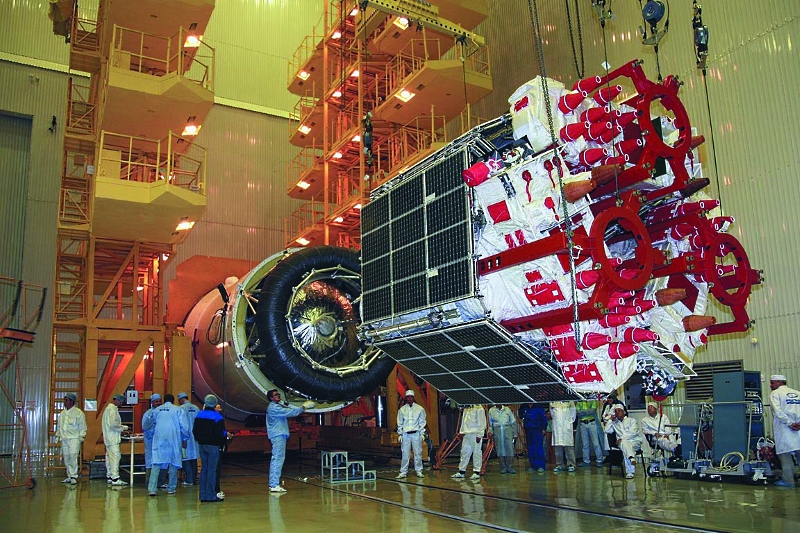
Preparations for the launch of three satellites "Glonass-M"
In general, in the history of GLONASS there was a period when the system actually turned out to be practically inoperable. By the second half of the 90s, the Soviet inertia of launching new devices had ended, already launched into orbit one after another broke, and by the beginning of the zero, 6-7 satellites were functioning, according to various sources, which was completely insufficient. But in 2001, they adopted the federal program “Global Navigation System”, allocated funds, and gradually, by the end of 2011, they redeployed the grouping to the full strength of 24 vehicles, not counting the reserve ones.
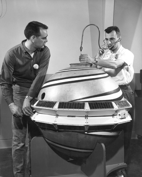
Early Transit Satellite Launch Preparation
Plunging into history even deeper, satellite navigation systems have been an attribute of a superpower since the beginning of the space age. The Americans were the first to create the Transit system to ensure the combat duty of their submarines with ballistic missiles. The first satellite went into orbit in 1960, and was officially adopted by Transit in 1964. The USSR was somewhat overdue, Cyclone satellites began to be launched from 1967, and adopted it in 1976. But the Cyclone system provided not only navigation, but and communication. Then, at about the same time, on both sides of the ocean, they began to develop second-generation systems, and the American NAVSTAR / GPS was fully deployed in 1993, and the Russian GLONASS - in 1995. Both systems turned out to be similar. Is that GLONASS works better in high latitudes, but, contrary to a common mistake,
When in orbit under the thirty devices of the grouping, the breakdown of the next is a normal working event. And to understand how this will affect the functioning of GLONASS, it is necessary to understand the principles of its work.
Let's start with a simplified problem on the plane. Imagine that we were in an unknown place and we want to determine where we are. As luck would have it, passers-by that come across to us can only report distances to any settlements without a direction. We are armed with a map, compass and begin to draw. The first passer-by says that to Moscow in a straight line 160 km. So we can be anywhere in the circle. The second - that to Smolensk 275 km. The search area is narrowed down to two points where the circles intersect. The third one says that 310 km to Kursk, and we can now say for sure that the compiler of the task has abandoned us to Kaluga.

Figure gisgeography.com
In three-dimensional space, the principle is the same, only the intersection of two spheres is a circle, three are two points, and only the intersection of four spheres will give us the exact location. And the illustration becomes too complicated to start right away from it.
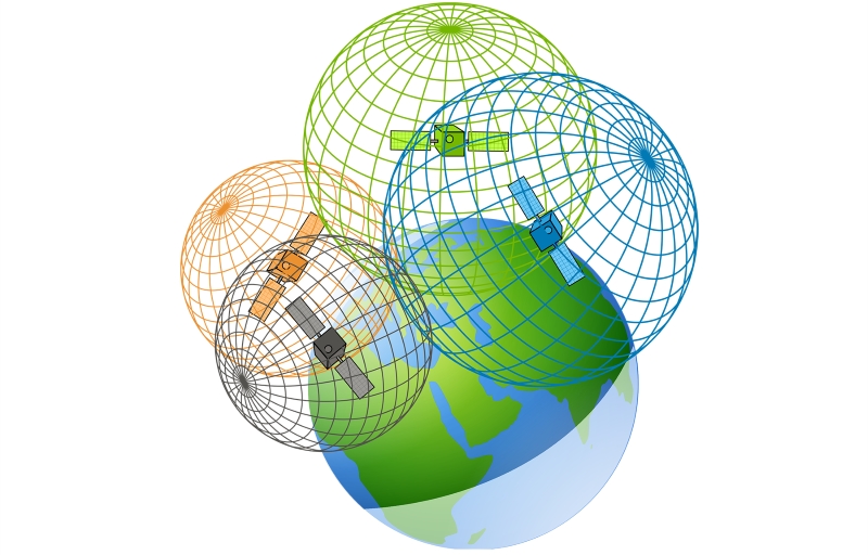
Picture gisgeography.com
In simple terms , GPS or GLONASS satellites constantly broadcast the exact time and parameters of their orbit. The ground receiver cannot determine directions, but it calculates where the satellite is in space by the parameters of the orbit, and calculates the distance to the satellite from the delayed time signal from the satellite to the receiver at the speed of light.
In theory, everything works very simply, but in practice it is necessary to take into account the arising interference.
Atmospheric interference, illustration gisgeography.com
First of all, the signal from the satellites is distorted by the atmosphere. Therefore, ground stations make sense and are actively used - if we know its exact location, we can calculate changes in the speed and direction of propagation of a signal from a satellite and send corrections to receivers located in the same area.
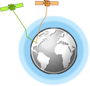
Further, the mutual position of the satellites matters. For a perfect position determination, one satellite should be directly above your head, and the three remaining ones - evenly distributed just above the horizon. And if all the devices in the sky next to each other, then the accuracy drops due to the geometrically inappropriate position.
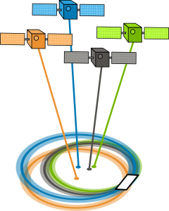
Illustration of gisgeography.com
In addition, there are interferences in the signal re-reflection from the satellite from ground objects, the accuracy problems of the atomic clocks on the satellite (even nanoseconds will introduce errors here), inaccuracies in the determination of satellite orbits and other factors.
It turns out that when one of the satellites fails, in some places, instead of him, you have to choose the signal of the other, in a worse position, which increases the error. Naturally, when one unit breaks down, it does not disable the entire system. So the news “GLONASS stopped working all over the world” should be more correctly rephrased to “in some areas of the Earth, a deterioration in the positioning accuracy is expected”. But this, of course, does not sound so clickbate.
The GLONASS information center monitors the accuracy of the signal and displays it on its website.. Now, when 24 devices are functioning, the accuracy is uniformly good on the map, but in case of breakdowns, zones with a larger error will appear. Satellites can maneuver in orbit, so the control center positions them so as to reduce the drop in accuracy of incomplete constellations.

A separate irony is that civilian users will not notice any changes at all, because since 2011 they have been producing chips that work simultaneously with GPS and GLONASS, and now receivers are able to work also with the Chinese "Beidou" and European Galileo, even if they are not fully deployed. Therefore, the civilian device in 2018, even being far from the ideal place, sees two dozen satellites.

The experiment from the balcony, to the west and south satellites obstruct the house, nevertheless the accuracy is 4 meters
It is known that today there are no backup satellites in the second and third orbital planes. According to the most recent data, the next launch of the Glonass-M satellite will be in October, so it is quite possible that we will have time to read the new iteration of the creepy news.
The situation in the system can be submitted in two opposite ways:
Personally, the second option is closer to me - for modern satellites, the rate exceeds the planned work time, and there is no sense in changing the devices that can be functioning for a long time. At the same time, the absence of an orbital reserve in two planes out of three and the apparent inability to instantly launch a new replacement satellite means that after an accident in the second or third planes for several months, the grouping will be incomplete. From the outside, we cannot estimate the degree of risk that the operators have taken, only time will tell us the success of the chosen path.
Satellite navigation very quickly became an integral part of modern life. It is used not only by "serious" military, pilots and seafarers, now it is taxi services, fitness, drones, photos with geotags and many other applications. And so far the world is unanimous that a developed country should have its own navigation system. Europe, China, India prefer to create their own constellations of satellites, rather than using ready-made GPS. GLONASS, albeit on the second attempt, has become a full-fledged and demanded navigation system, and the next time you see a bright title, do not rush to give in to emotions.
Preparations for the launch of three satellites "Glonass-M"
A bit of history
In general, in the history of GLONASS there was a period when the system actually turned out to be practically inoperable. By the second half of the 90s, the Soviet inertia of launching new devices had ended, already launched into orbit one after another broke, and by the beginning of the zero, 6-7 satellites were functioning, according to various sources, which was completely insufficient. But in 2001, they adopted the federal program “Global Navigation System”, allocated funds, and gradually, by the end of 2011, they redeployed the grouping to the full strength of 24 vehicles, not counting the reserve ones.
Early Transit Satellite Launch Preparation
Plunging into history even deeper, satellite navigation systems have been an attribute of a superpower since the beginning of the space age. The Americans were the first to create the Transit system to ensure the combat duty of their submarines with ballistic missiles. The first satellite went into orbit in 1960, and was officially adopted by Transit in 1964. The USSR was somewhat overdue, Cyclone satellites began to be launched from 1967, and adopted it in 1976. But the Cyclone system provided not only navigation, but and communication. Then, at about the same time, on both sides of the ocean, they began to develop second-generation systems, and the American NAVSTAR / GPS was fully deployed in 1993, and the Russian GLONASS - in 1995. Both systems turned out to be similar. Is that GLONASS works better in high latitudes, but, contrary to a common mistake,
In the crosshairs of spheres
When in orbit under the thirty devices of the grouping, the breakdown of the next is a normal working event. And to understand how this will affect the functioning of GLONASS, it is necessary to understand the principles of its work.
Let's start with a simplified problem on the plane. Imagine that we were in an unknown place and we want to determine where we are. As luck would have it, passers-by that come across to us can only report distances to any settlements without a direction. We are armed with a map, compass and begin to draw. The first passer-by says that to Moscow in a straight line 160 km. So we can be anywhere in the circle. The second - that to Smolensk 275 km. The search area is narrowed down to two points where the circles intersect. The third one says that 310 km to Kursk, and we can now say for sure that the compiler of the task has abandoned us to Kaluga.
Figure gisgeography.com
In three-dimensional space, the principle is the same, only the intersection of two spheres is a circle, three are two points, and only the intersection of four spheres will give us the exact location. And the illustration becomes too complicated to start right away from it.
Picture gisgeography.com
In simple terms , GPS or GLONASS satellites constantly broadcast the exact time and parameters of their orbit. The ground receiver cannot determine directions, but it calculates where the satellite is in space by the parameters of the orbit, and calculates the distance to the satellite from the delayed time signal from the satellite to the receiver at the speed of light.
In theory, everything works very simply, but in practice it is necessary to take into account the arising interference.
Atmospheric interference, illustration gisgeography.com
First of all, the signal from the satellites is distorted by the atmosphere. Therefore, ground stations make sense and are actively used - if we know its exact location, we can calculate changes in the speed and direction of propagation of a signal from a satellite and send corrections to receivers located in the same area.
Further, the mutual position of the satellites matters. For a perfect position determination, one satellite should be directly above your head, and the three remaining ones - evenly distributed just above the horizon. And if all the devices in the sky next to each other, then the accuracy drops due to the geometrically inappropriate position.
Illustration of gisgeography.com
In addition, there are interferences in the signal re-reflection from the satellite from ground objects, the accuracy problems of the atomic clocks on the satellite (even nanoseconds will introduce errors here), inaccuracies in the determination of satellite orbits and other factors.
It turns out that when one of the satellites fails, in some places, instead of him, you have to choose the signal of the other, in a worse position, which increases the error. Naturally, when one unit breaks down, it does not disable the entire system. So the news “GLONASS stopped working all over the world” should be more correctly rephrased to “in some areas of the Earth, a deterioration in the positioning accuracy is expected”. But this, of course, does not sound so clickbate.
The GLONASS information center monitors the accuracy of the signal and displays it on its website.. Now, when 24 devices are functioning, the accuracy is uniformly good on the map, but in case of breakdowns, zones with a larger error will appear. Satellites can maneuver in orbit, so the control center positions them so as to reduce the drop in accuracy of incomplete constellations.
A separate irony is that civilian users will not notice any changes at all, because since 2011 they have been producing chips that work simultaneously with GPS and GLONASS, and now receivers are able to work also with the Chinese "Beidou" and European Galileo, even if they are not fully deployed. Therefore, the civilian device in 2018, even being far from the ideal place, sees two dozen satellites.
The experiment from the balcony, to the west and south satellites obstruct the house, nevertheless the accuracy is 4 meters
Strategy issues
It is known that today there are no backup satellites in the second and third orbital planes. According to the most recent data, the next launch of the Glonass-M satellite will be in October, so it is quite possible that we will have time to read the new iteration of the creepy news.
The situation in the system can be submitted in two opposite ways:
- “About half of the satellites of the current Glonass orbital group have developed a warranty period. At the same time, there are only five Glonass-M devices in the ground reserve. ”
- “The GLONASS satellites finally learned to do so that they began to work longer than the warranty period, and, until the old ones broke down, it makes no sense to launch new ones. And in case of major problems, we have as many as five spare in storage. ”
Personally, the second option is closer to me - for modern satellites, the rate exceeds the planned work time, and there is no sense in changing the devices that can be functioning for a long time. At the same time, the absence of an orbital reserve in two planes out of three and the apparent inability to instantly launch a new replacement satellite means that after an accident in the second or third planes for several months, the grouping will be incomplete. From the outside, we cannot estimate the degree of risk that the operators have taken, only time will tell us the success of the chosen path.
Conclusion
Satellite navigation very quickly became an integral part of modern life. It is used not only by "serious" military, pilots and seafarers, now it is taxi services, fitness, drones, photos with geotags and many other applications. And so far the world is unanimous that a developed country should have its own navigation system. Europe, China, India prefer to create their own constellations of satellites, rather than using ready-made GPS. GLONASS, albeit on the second attempt, has become a full-fledged and demanded navigation system, and the next time you see a bright title, do not rush to give in to emotions.