Beetles are attacking
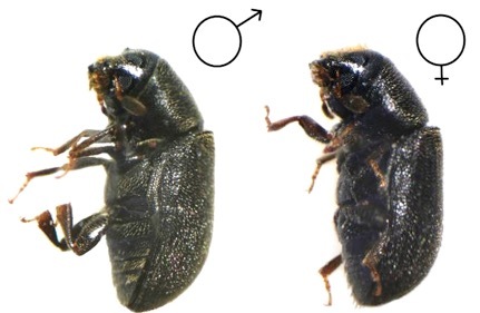 I have already done on Habré a post about the destruction of Siberian forests by a dangerous pest - the Ussuri polygraph . This extremely prolific and dangerous beetle is capable of destroying huge areas of fir forests in a short time and, unfortunately, it turns out much better for it than the efforts of people to fight a dangerous insect. The main problem of monitoring forests in the area affected by the beetle is the lack of specialists and modern techniques for quick and accurate analysis of the state of the affected forest. However, some positive moments still exist. Unmanned aerial vehicles are going to fight with a dangerous pest. UAV. Rather, take off ...
Forest monitoring. What it is?
To date, monitoring of the status of fir forests in the affected area Polygraphus proximus ( scientific name of the beetle - author's note) was carried out in the course of periodic ground-based observations (more simply, legs), which is especially important in the case of detection of pest outbreaks and the appointment of sanitary and recreational measures. This may be a special cutting, processing of biological products or chemical reagents. However, such studies, due to the vastness and inaccessibility of the taiga territories of Siberia, do not provide complete information on the spread of the invasive process in the region. Partially, this problem could be solved by the use of satellite imagery and aviation surveillance, but these methods have an extensive list of limitations on the detail of information, and, importantly, on cost.
Recently, the implementation of forest pathological surveys is possible by remote method using unmanned aerial vehicles, as defined in the Order of the Ministry of Natural Resources of Russia No. 480 of September 16, 2016. The rare case when Russia was relatively quickly allowed to apply modern technologies to solve such acute problems.
Methods of assessing the state of the forest with the help of UAVs
It would seem that there is difficult? Take pictures of the forest and everything with the help of the UAV. But this is only apparent simplicity. Optimal conditions for remote sensing of forest plantations using UAVs are determined by the range of tasks and, therefore, the type of device, its technical characteristics and recommendations of the manufacturer of the UAV. However, not every drone can be suitable for this kind of tasks. For choosing the time of aerial photography, good visibility with a minimum lower cloud limit of about 300 meters under the condition of uniform illumination is of paramount importance.

Partly cloudy or low angles of morning or evening sunlight are not recommended, since the crowns of damaged trees may not be clearly visible in the shadows. The optimal timing for aerial photography using UAVs usually coincide with the periods of ground surveys of stem pest foci from mid-April to early October.
Select the type of UAV
For operational surveys of small areas of the affected forest, semi-industrial UAVs are used, the characteristics of which make it possible to obtain images no worse than 4000 × 3000 pixels. The area of coverage of the territory when the UAV is raised 300 m above the ground is 0.2 km², and at an altitude of 500 m it is 0.5 km². The function of keeping the UAV at a given location and height allows you to work as an “observation tower” with a radius of view of 3–4 km. This allows not only to assess the state of the forest, but also to record possible fires.
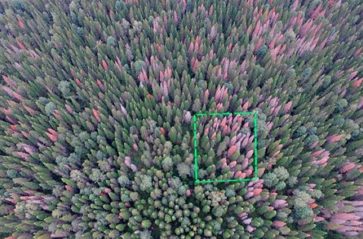
Quadcopter allows you to carry out operational inspection of forest areas in the mode of photographing and video. The trees damaged by the Ussuri polygraph are detected in the pictures by a change in the color of the crown compared to intact trees, which makes it easy to differentiate between living and dead trees and to estimate their health status and level of degradation approximately by their share in the stand. The initial stage of the destruction of the tree leads to a slight change in the structure and color of fir, as can be seen in this photo.
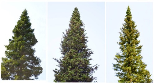
However, after a few weeks it becomes noticeable that the defeat becomes irreversible. The tree dies and dries out, becoming a source of increased fire danger.

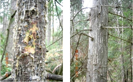
It looks like a tree trunk, struck by a polygraph. It has a large number of holes, which the beetle bit through, penetrating under the bark. In this case, the tree includes a protective mechanism against the pest (it emits a lot of resin), but this weakens the tree so much that it dies in a few weeks.
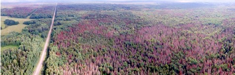
In the pictures with UAVs, the affected forest appears multi-colored. At the same time, green trees are not yet affected by a dangerous pest, and the color trees are in the extreme stage of destruction. This area of the forest is doomed. The damage by the pest is so large that in a year it will be only deadwood and fodder in this place, or this area will be covered by a forest fire.
Wing-type UAVs are more suitable for monitoring large forest areas. In particular, a device equipped with a SONY A6000 digital camera (24 megapixels; lens focal length f = 20 mm; sensor type: CMOS; matrix size: 23.5 × 15.6 mm; resolution) was tested for examining plantings damaged by the Ussuri polygraph. 6000 × 4000 pixels.)

Processing and interpretation of images from UAVs
The most important task for specialists is the assessment of forest monitoring results from UAV images. Taking into account the vast territories and a large amount of data, in our opinion, the creation of a neural network for analyzing the information received would be promising, since the affected trees in the images show certain and sufficiently clear and repeated interpretation signs (the crown color changes). This is how the crowns of trees look according to the degree of infestation by the pest, which can be conventionally taken as “exemplary”. Here, fragments of crowns in the form of images with a certain resolution of several tens of pixels are selected from forest images. Such "exemplary" images (several thousand to begin with) can be a database for a test neural network. Of course, the images must be somehow normalized and prepared for analysis, and this, of course,
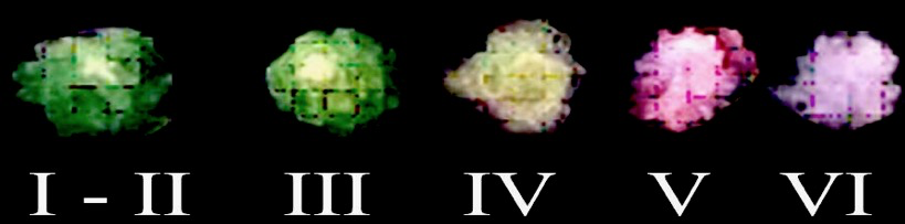
I is a healthy tree; II - weakened tree; III - strongly weakened
tree; IV - dying tree; V - fresh dead; VI - the old deadwood
Training and training the network to analyze such images, you can get a powerful tool for assessing the state of forests and at the same time significantly reduce the human factor in making decisions on assessing the degree of damage to the stand. However, this is a separate task that requires an additional solution. In future. Someone from dear Habr's readers can tell (in comments or in person) how to solve this task in the most optimal and interesting way. Either someone will share experiences in this direction or will indicate ready-made solutions?
Underwater rocks
Well, not without them. The use of UAVs is generally associated with huge obstacles and various restrictions. On the one hand, great technology, but has a number of problems. Administrative, related to the registration of the UAV, the opening of airspace, the atrocities of the regulatory bodies on the one hand, and technical problems - on the other. UAV is still quite “raw” technology, so losing a drone in the Siberian forest due to telemetry failure or technical problems is very simple. The spread of radio waves in the forest complicates the dense forest canopy, the complex landscape of the territory. It is not always possible to meet all the requirements of the firmware in the UAV and, first of all, because of a poor Internet connection. As experience shows, modern UAVs constantly want to get something from the Internet (or transmit something there) and sometimes simply do not want to fly in the complete absence of a network. But,
Fir forest monitoring technology
 The method of assessing the status of fir forests in areas of damage by a dangerous pest is summarized in a special tool that can be freely downloaded for familiarization with specialized specialists (ISBN 978-5-9907381-1-9). This manual is the result of the work of a large team of researchers at the Institute for Monitoring Climate and Ecological Systems of the Siberian Branch of the Russian Academy of Sciences. This manual will be very useful to forestry specialists, as well as to specialists who conduct the analysis of the state of forest resources, environmentalists, scientists, foresters.
Team of authors
Я лично хорошо знаком с некоторыми авторами этой работы и не перестаю восхищаться самоотверженностью и энтузиазму этих людей. В такое тяжелое время для российской науки, когда нет денег ни на экспедиции, не на полевые работы, а большей частью за собственные средства и на собственных автомобилях эти люди организуют экспедиции для проведения сложнейших научных экспериментов, что не может не вызывать глубокого уважения.
Вот имена этих замечательных людей
Кривец Светлана Арнольдовна, Бисирова Эльвина Михайловна, Волкова Елена Сергеевна, Дебков Никита Михайлович, Керчев Иван Андреевич, Мельник Мария Алексеевна, Никифоров Артем Николаевич, Чернова Наталья Александровна.
В разработке методики использования БПЛА существенный вклад внес Иван Керчев. Его работы по исследованию опасных вредителей лесов известны многим российским и иностранным ученым. Молодой и чрезвычайно талантливый и обаятельный человек. На фото Иван в экспедиции готовит дрон к полету.
PS When preparing this post, I accidentally stumbled upon an interesting live broadcast on Vesti24 about the problems of forestry in the evening . Here is the link . From the air, I learned that in the Soviet Union, the sale of the forest helped out currency more than from the sale of oil, that in the forest industry now there are not just problems, but in general ... I was surprised by this broadcast and the acuteness of the conversation of invited experts. Although judge for yourself! Ether, however, almost 50 minutes, take into account this moment. In this broadcast, in particular, the experts touched upon the problems about which I am writing in this post.