Roscosmos geoportal opened
Today, December 21, 2010, at the time of the winter solstice, the Roscosmos geoportal was opened. The discovery was planned earlier, but was delayed by the fall of three GLONASS satellites into the Pacific Ocean.
Below, under the cut - the first impressions from the opening ceremony, and photos.
Geoportal is already available: geoportal.ntsomz.ru
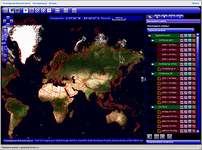
It is a two-dimensional cartographic aggregator of remote sensing data (DDZ), vector information. Declared functionality for creating data by users themselves, but have not been tested yet. The portal was opened by Yuri Urlichich (RKS OJSC), GLONASS General Designer.
The main component - raster coating - includes images from the following devices:
1. Meteor-3M. Conditional colors, resolution 60 m / pixel. The satellite is good, equipped with a SAR radar, and if the antenna of the latter opened, there would be no price for it, they said on the sidelines.
2. Resource-recreation center. Panchromatic images with a resolution of something around 2m. The only Russian
ultra-high-resolution spacecraft with data transmission over the air, and not using film. Pictures are in commercial quantities.
3. Monitor-E. rarity and curiosity.
4. Terra (USA), Alos (Japan), Spot (France), QuickBird (USA) - are present in single copies, rather as demonstrators.
4. LandSat (USA) - basic coverage.
The functionality and interface of the portal make a good impression, evaluate the loading characteristics, speed of response, etc. so far failed. Software - developed at NIITP, possibly using OpenSource.
The absolute accuracy of the image binding is 60 m. The
geoportal will be [partially] paid. Low-resolution images will be laid out daily for ordinary mortals, high-resolution images (probably it was only about operational shooting) will be open only to paid subscribers of the service. Alas.

The opening ceremony of the geoportal. Speaker Yuri Urlichich

Spacecraft mission planning hall. In the foreground is a test mission test bench for the promising Russian remote sensing satellite (remote sensing Earth) Canopus-B manufactured by VNIIEM. The Canopus-B satellite is being created with the help of the UK.

Screen panels of the
UPD Mission Planning Center . At the request of TarzanASG , I add that OpenStreetMap - OSM is also declared in the list of vector layers on the Roskosmos geoprotal , this layer is in the resource directory. It seems to open, although I did not succeed.
UPD1 Dropbox, on which pictures from the article were laid yesterday, could not stand it - a notification was received about access restriction due to abnormal traffic. If I can put on habrastorage - I will transfer. While it also does not open.