Pix4D - from photos to measurements

Quadcopters and various UAVs are gradually becoming familiar tools in many areas of professional activity. It is very difficult to overestimate the possibilities of drones in the hands of photographers and videographers, but it is possible to fully realize the potential of these devices in the field of industry and geodesy. In particular, if the kopter is operated by specialized software, and aerial photography materials are processed by computer and used to analyze various data.
Some companies produce software to solve specific problems, but there are projects that are suitable for several fields of activity at once. One of these manufacturers is the Swiss company Pix4D, which since 2011 has been developing various solutions in the field of photogrammetry. Starting as a branch (or rather, computer vision laboratories) of the largest polytechnic university in Europe, EPFL, today Pix4D has become one of the fastest growing companies in the world. Based on its rich experience in creating software for converting multispectral images into 3D models and three-dimensional maps, the company has developed a whole line of software products useful in the field of construction and cadastre, agriculture, aerial photometry and real estate.
How does it work

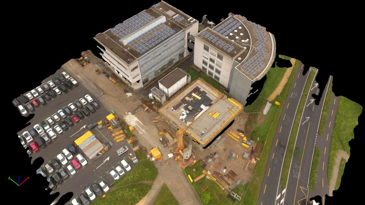
Pix4D products allow you to automatically shoot hundreds of photos from different angles onto a quadrocopter camera, which are processed and combined into a single topographic map or 3D model using a special algorithm. In simple terms, the principle of the program is very similar to the principle of the human vision. Our eyes see the same object at different angles, and the brain, based on this difference, transforms these images into a three-dimensional image.
To begin with, the user is required to select one of the available control types. It is possible to select the free flight mode (Freeflight mission), in which the operator is responsible for the movements of the copter, and the camera makes a new frame after changing the position of the drone to the specified value horizontally and vertically.
In automatic modes, to build a digital elevation model (DTM), it is required to set in the application the boundary of the object to be removed, flight altitude, camera tilt angle and other parameters. Take-off and landing are carried out automatically, but the pilot must have UAV control skills if unforeseen difficulties or obstacles arise in the path of the drone.
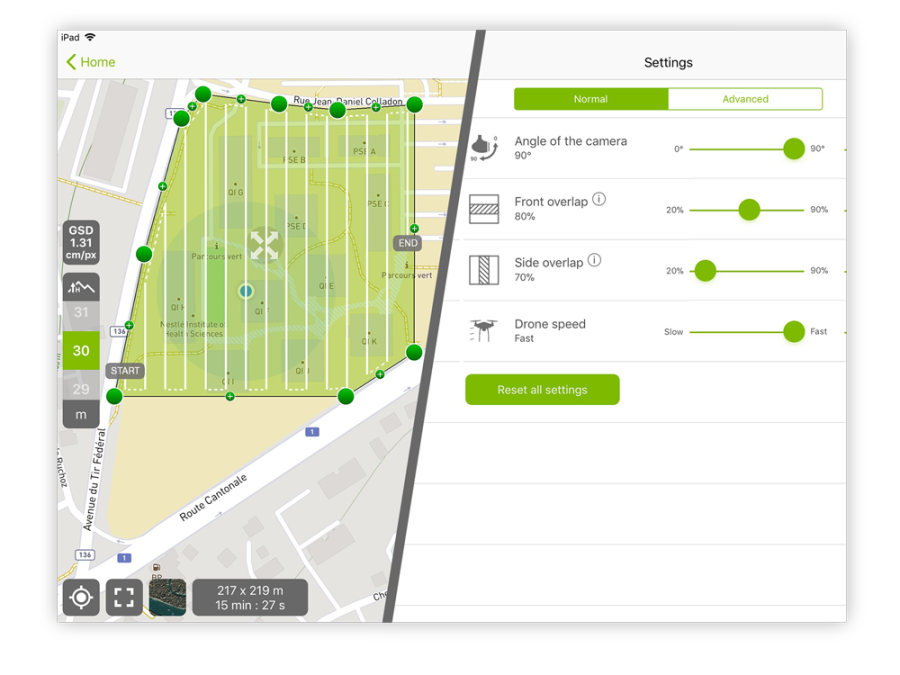
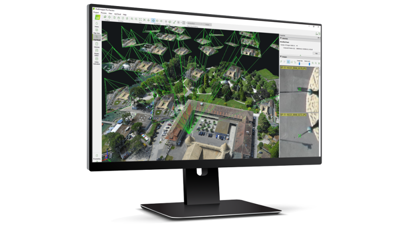
After takeoff, the quadcopter automatically flies over the area to be shot, making the required number of frames. The program also records information about each photo in a separate EXIF-file, which specifies the data of longitude and latitude, flight altitude and camera angle. After the survey is completed, the received data must be imported into the Pix4D program or sent to the cloud storage for processing. With the help of pattern recognition technology, the search for common or “connecting” points in photographs will begin: unique similar combinations of pixels are searched for by color and geometric arrangement on different photographs, with the result that this coincidence becomes a key point. The more matches are found, the more accurately the model is built. To build a point of this model in space, it is necessary to match at least three photographs,
Next, the spatial coordinates of each key point are calculated by triangulation and extracting data from the EXIF file. The image is taken from the central area with which the photograph was taken, and from it the line of sight is drawn up to each key point found in the photograph. The result of the intersection of these lines gives the desired value of the spatial coordinates. In addition, the Levenberg-Marquardt algorithm or the bundle method is used to minimize the sum of squares of the set of errors.
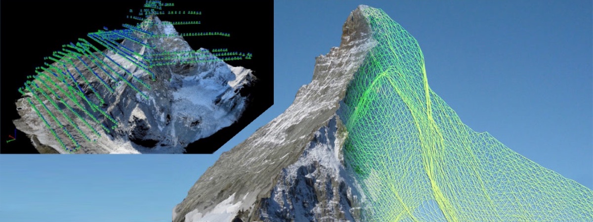
Based on all these calculations, the program builds an expanded cloud of points to generate a removable surface composed of polygons or meshes. And the last step is the calculation of the size of the pixels and the determination of the correspondence of the pixels in the photo to the generated mesh.
Upon completion of the program, you get a three-dimensional model of the area you need. You can change the scale, adjust the contrast and brightness, heat balance, import the data into GIS and CAD programs, measure the volume of earthworks, use the orthophotomap editor to select the desired fragment from a set of images, and other features.
Spheres of application
The program line from Pix4D includes such products as Pix4Dmapper, Pix4Dfields, Pix4Dmodel, Pix4Dbim, as well as the free application Pix4Dcapture for plotting flight routes for the copter.
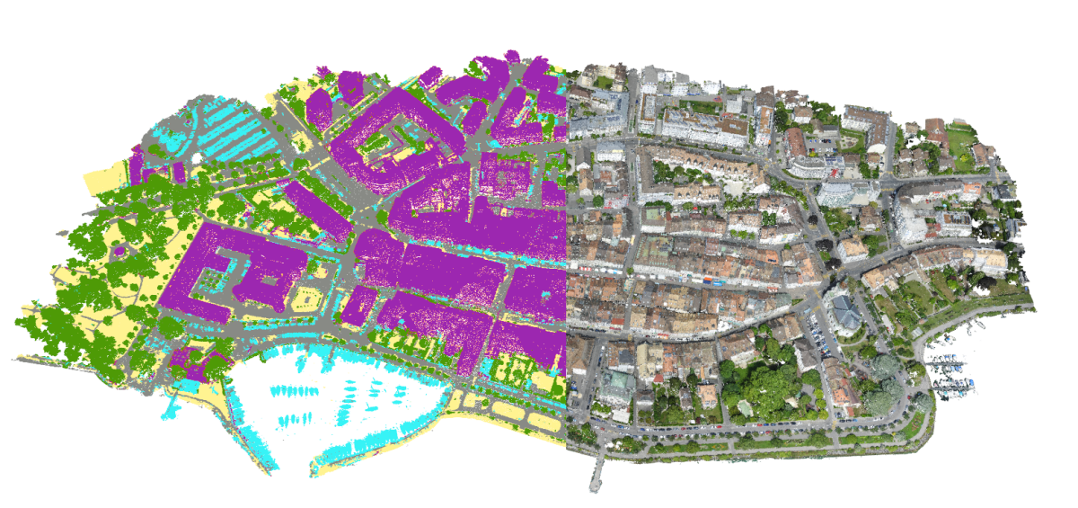
The potential of using software from Pix4D in industrial areas is enormous. First and foremost, of course, software is used in geodesy, cartography, and aerial photometry, to build accurate 3D maps. Pix4Dmapper is suitable for solving problems from this area. This is a tool with rich functionality. With it, you can convert aerial photographs of terrain into a three-dimensional image. The processing itself takes place either on the computer or in the Pix4D cloud storage, where it is necessary to send all the collected data for conversion. The program has the ability to measure the size, area and volume of objects obtained on the 3D-model. It helps to conduct site inspections remotely. Accuracy of shooting is from 1 to 2 cm / pixel in planes X and Y, as well as from 1 to 3 cm / pixel in the Z plane (depending on the height difference of the area being removed). It is also possible to classify a cloud of points: the necessary elements of the model and the surface (land, asphalt, high vegetation, buildings, objects created by man) are highlighted in colors for accurate analysis and subsequent adjustment of the project. With the help of Pix4Dmapper, a high resolution orthomosaic, a digital model of terrain and terrain, a contour contour map and reflectivity, as well as maps with temperature values are obtained.

Representatives of the socio-cultural sphere and real estate will be interested in another tool called Pix4Dmodel. With its help, digitized historical monuments, UNESCO World Heritage, architectural structures are produced. The resulting models can be used as interactive objects in programs for VR headsets, or for creating video clips of the flight and subsequent publication on popular video hosting sites. You can export the resulting model in various popular formats (.bj, .fbx, .dxf, .ply) for use in modeling programs and 3D printing.
For the agricultural industry developed its own tool. Pix4Dfields allows you to calculate and compare spectral indices and vegetation indices, build geofences and orthmoosaics.
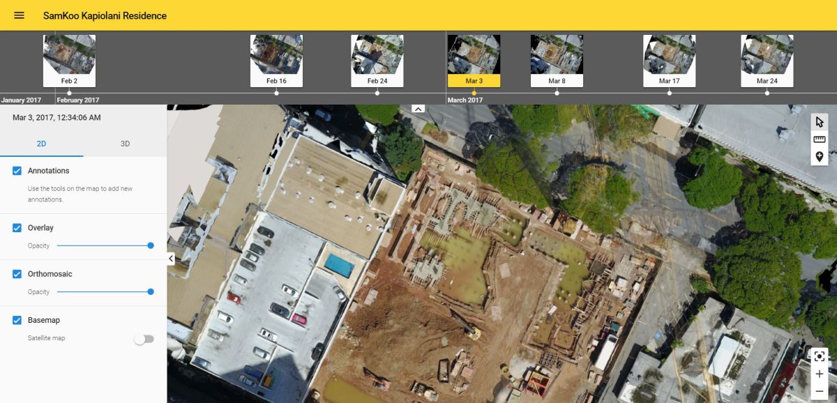
Pix4Dbim is a powerful program for construction companies. With it, the user gets a complete picture of his project through the automatic construction of topographic and contour maps of the area, two-dimensional or three-dimensional projections, chronological scale, which displays all the stages of construction work. In Pix4Dbim, it is very easy to assess construction progress: just export CAD drawing images and compare them with BIM data obtained by simple overlay.
And, of course, the data and models received in all tools can be uploaded to the Pix4D cloud, leave a comment, a prescription and share with the customer or your team.
Restrictions
There are some minor flaws in the Pix4D product. The program recognizes any reflective surfaces as a structural element and automatically processes them to create a model. Such bugs are easily eliminated by the built-in tools, but for digitizing the sea surface or Pix4D lakes is not suitable yet.
Also in automatic mode there are restrictions on the area of aerial photography for one flight. The higher the height (the worse the resolution) and the lower the degree of overlap (the smaller the key points and the lower the accuracy of the model's reconstruction), the more territory can be covered at one time. For example, a Phantom 4 Pro quadcopter model with a shooting height of 200 meters (5.5 cm / pixel) and minimal overlap (75% longitudinal and 60% transverse) can capture 100 hectares of terrain. This is due to the operating time of the UAV from one battery. However, no one bothers to replace the battery and continue the mission from the point where the previous shooting was completed. Modern route planning applications allow you to do this. And technology does not stand still, and each new model of the copter can hold out in the air longer and longer. Don't forget
The software from Pix4D supports work with most modern drones, speeds up and simplifies the process of photogrammetry, digitization and the construction of 3D-models. Industrial companies no longer need to suffer losses by hiring a helicopter for inspections. Pix4D allows for quick and accurate reconnaissance of the area, as well as collect and process information necessary for the user automatically. A few years ago, many companies could only dream of such. But thanks to the development of technology and production of UAVs, the ability to create accurate 3D maps becomes available even for small firms.