Ukrainian land registry uses OSM as default map
In Ukraine, opened access to the State Land Cadastre . They even washed down the interactive map: www.map.land.gov.ua/kadastrova-karta Respect
privacy and do not publish the names of the owners. You can see the cadastral number, if the cadastre indicates the privatization of the site, then this fact and the purpose of the site are indicated. But nothing about the owner. And still interesting.
In particular, Ukrainian optimizers are not alien to the use of open crowd-sourced map sources. By default, a map opens with a map layer from OpenStreetMaps .
UPD:And what is even more interesting, in the “Orthophotomaps” mode, unidentified satellite images are used so far, which quite evenly cover almost the whole of Ukraine, and in many distant regions. The centers of the districts have granularity far superior to google / bing / yandex maps.
UPD2: Unverified, but very similar to the truth, information was received that the orthophotomaps are their own maps of the center of the spare wheel bracket (state land cadastre): www.kmu.gov.ua/control/publish/article?art_id=244580259
UPD3: Received information from now habrovchanina drobzik , thank him for her:
I do not belong directly to the developers of this site, but I take part in the implementation of this project, and I can give "unofficial" answers.
1) where are these satellite maps from
? These are not a satellite, they are honest aerial photography and honest orthophotomaps. Some surveys were made, for example, by the ARC company, commissioned by the Goskomzem (State Committee for Land Resources) of Ukraine, as part of the Mirbank project to create a land cadastre system of Ukraine (here the news is www.avia.org.ua/en/node/237 ) Because in general, the survey was carried out over several years, some of the information on them may be slightly outdated, but still now - this is the most complete and accurate photographing of the territory of Ukraine.
2) how can they be used (does their license allow them to be used to expand OpenStreetMaps, for example).
The owner of these cards was at the time of the shooting of the State Land Committee of Ukraine. Over the past couple of years, it has been renamed and reassigned several times, so it’s quite difficult to find out exactly who the owner is now. Under the auspices of the Goskomzem, several different organizations have been created, partly for conducting commercial activities, partly for sharing functional responsibilities. For simplicity, we can assume that the owner of the orthophotocards is the state (Ukraine, in this case), in connection with which, you are unlikely to get official permission to use them anywhere and from anyone (they just don’t understand what you want to get from them ) However, on the other hand, no one will chase you for using these cards for your needs (or for non-commercial purposes), because the government doesn’t care, and officials are interested only in the case of material gain.
And, of course, this state source of cadastral information displays the whole truth from OSM - popular maps, for example, the facts of illegal seizure of territory in Kharkov Forest Park, designated there as "Self-capture" ( UPD4 already sawed off self-captures from OSM, so that only the screenshot remains) :

(in the screenshot there is no proper land included in the inventory - they appear blue polygons, but in this area in the inventory simply no site yet)
himself inventory - young enough, and there come not everyone even privatized ized areas (for details on how the challenges are pending cadastral number for the ordinary mortal - omitted). But the undertaking itself, including public access, is certainly good.
UPD5:More information about the sources of orthophotomaps (I just put all the information here in one place):
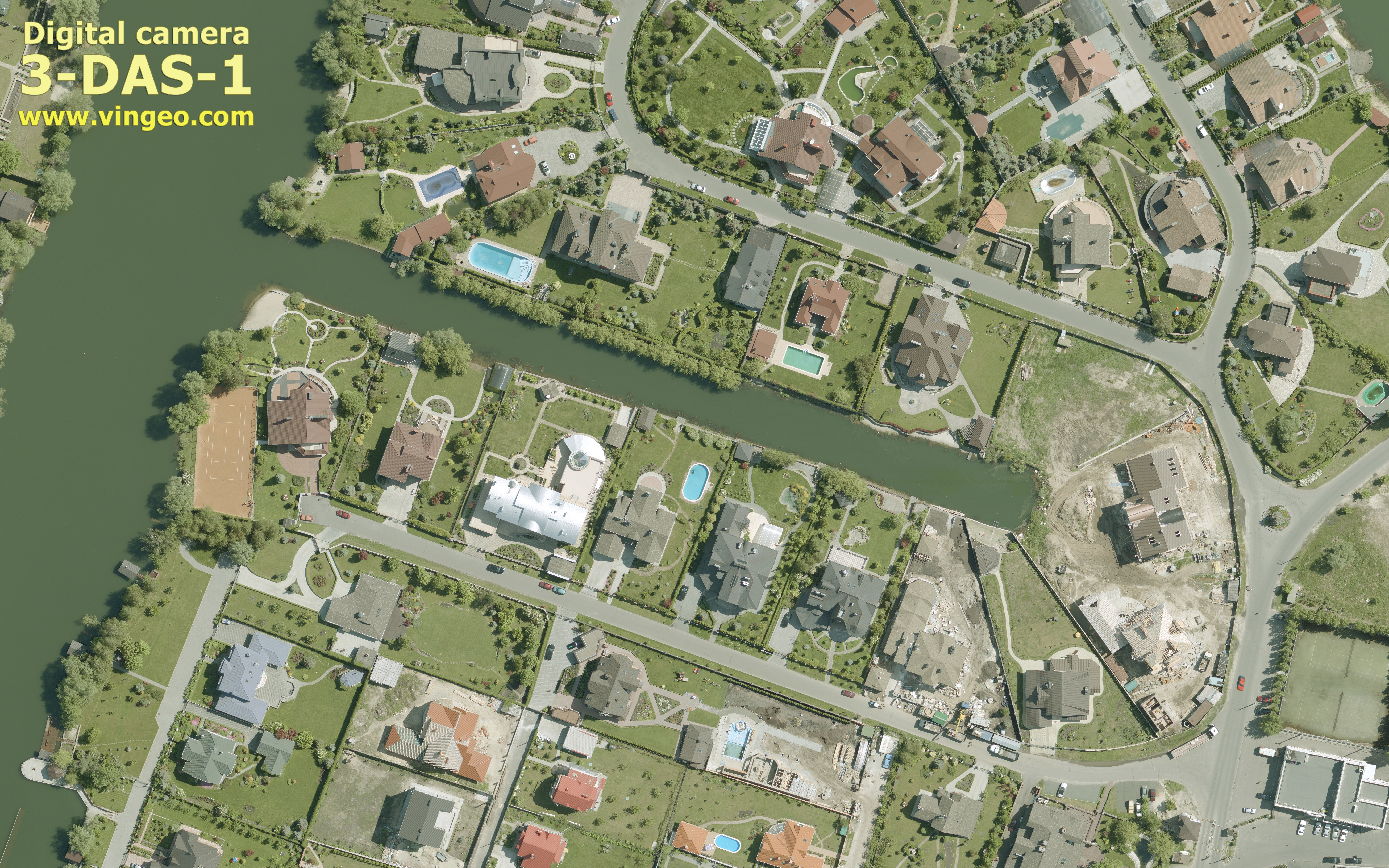
I also do not relate directly to the creation of the site map.dazru.gov.ua, but I can say from the aerial photography used for the site. Everything that drobzik wrote is absolutely true. But. Almost all aerial photography was carried out by GNPP Geosystem, the city of Vinnitsa. Here, part of the orthophoto was created from raw aerial photography. The principle of orthophoto was then taken out of aerial photography in many cities by many enterprises. You wrote about the quality of aerial photographs from Aero Geoinformatics. Look at the reference to examples of aerial photographs from the Geosystem. www.vinmap.net/?act=aero , www.geosystema.net/DAS/DASSample.jpgIn general, all the orthophotomaps for the cadastral map were made using the Digitals software, aerial photography was carried out by cameras made also in the Geosystem. Here is the site: vingeo.com/Rus/index.html of the enterprise itself, if interested.
privacy and do not publish the names of the owners. You can see the cadastral number, if the cadastre indicates the privatization of the site, then this fact and the purpose of the site are indicated. But nothing about the owner. And still interesting.
In particular, Ukrainian optimizers are not alien to the use of open crowd-sourced map sources. By default, a map opens with a map layer from OpenStreetMaps .
UPD:And what is even more interesting, in the “Orthophotomaps” mode, unidentified satellite images are used so far, which quite evenly cover almost the whole of Ukraine, and in many distant regions. The centers of the districts have granularity far superior to google / bing / yandex maps.
UPD2: Unverified, but very similar to the truth, information was received that the orthophotomaps are their own maps of the center of the spare wheel bracket (state land cadastre): www.kmu.gov.ua/control/publish/article?art_id=244580259
UPD3: Received information from now habrovchanina drobzik , thank him for her:
I do not belong directly to the developers of this site, but I take part in the implementation of this project, and I can give "unofficial" answers.
1) where are these satellite maps from
? These are not a satellite, they are honest aerial photography and honest orthophotomaps. Some surveys were made, for example, by the ARC company, commissioned by the Goskomzem (State Committee for Land Resources) of Ukraine, as part of the Mirbank project to create a land cadastre system of Ukraine (here the news is www.avia.org.ua/en/node/237 ) Because in general, the survey was carried out over several years, some of the information on them may be slightly outdated, but still now - this is the most complete and accurate photographing of the territory of Ukraine.
2) how can they be used (does their license allow them to be used to expand OpenStreetMaps, for example).
The owner of these cards was at the time of the shooting of the State Land Committee of Ukraine. Over the past couple of years, it has been renamed and reassigned several times, so it’s quite difficult to find out exactly who the owner is now. Under the auspices of the Goskomzem, several different organizations have been created, partly for conducting commercial activities, partly for sharing functional responsibilities. For simplicity, we can assume that the owner of the orthophotocards is the state (Ukraine, in this case), in connection with which, you are unlikely to get official permission to use them anywhere and from anyone (they just don’t understand what you want to get from them ) However, on the other hand, no one will chase you for using these cards for your needs (or for non-commercial purposes), because the government doesn’t care, and officials are interested only in the case of material gain.
And, of course, this state source of cadastral information displays the whole truth from OSM - popular maps, for example, the facts of illegal seizure of territory in Kharkov Forest Park, designated there as "Self-capture" ( UPD4 already sawed off self-captures from OSM, so that only the screenshot remains) :
(in the screenshot there is no proper land included in the inventory - they appear blue polygons, but in this area in the inventory simply no site yet)
himself inventory - young enough, and there come not everyone even privatized ized areas (for details on how the challenges are pending cadastral number for the ordinary mortal - omitted). But the undertaking itself, including public access, is certainly good.
UPD5:More information about the sources of orthophotomaps (I just put all the information here in one place):
I also do not relate directly to the creation of the site map.dazru.gov.ua, but I can say from the aerial photography used for the site. Everything that drobzik wrote is absolutely true. But. Almost all aerial photography was carried out by GNPP Geosystem, the city of Vinnitsa. Here, part of the orthophoto was created from raw aerial photography. The principle of orthophoto was then taken out of aerial photography in many cities by many enterprises. You wrote about the quality of aerial photographs from Aero Geoinformatics. Look at the reference to examples of aerial photographs from the Geosystem. www.vinmap.net/?act=aero , www.geosystema.net/DAS/DASSample.jpgIn general, all the orthophotomaps for the cadastral map were made using the Digitals software, aerial photography was carried out by cameras made also in the Geosystem. Here is the site: vingeo.com/Rus/index.html of the enterprise itself, if interested.