Nokia Maps on Windows Phone 8
After discussing the camera and wireless charging in the new Nokia Lumia 920 and Nokia Lumia 820 smartphones and the subsequent traditional srach, one of the most interesting pieces of these devices called “navigation” somehow blurred. I’ll try to make up for this shortcoming and list the main changes and additions to Nokia Maps under Windows Phone 8.
This is a slightly revised article by Pinot Bonetti, the original of which is here .

Offline maps are traditionally supported in WP8 along with other Nokia smartphones on other platforms such as Symbian and MeeGo. Those who prefer offline maps, note that they work faster and are cheaper, because you do not need to spend money on an Internet connection. In addition to these advantages, offline and online maps in WP8 can also be used by other, third-party applications through the corresponding API engine called Nokia Location Platform. This engine, which until recently existed as an API for JS (Web), JME (S40), Qt (Symbian & MeeGo), as well as in the form of REST services, is now available on Windows Phone 8 as a feature of the platform and in hybrid form - online and offline.
A distinctive feature in the Nokia Lumia 920 and 820- this is that they have autonomous A-GPS and A-GLONASS receivers installed . Existing Nokia phones with GPS suffer from the fact that offline mode in Nokia Maps disables A-GPS and as a result it takes a rather long time to wait until the device finds its current location. Now Lumia 920 and 820 promise the normal operation of A-GPS and offline including, that is, the location will be in a few seconds.
It should be added, for those who do not know that if the cards switch between offline and online modes, then all changes to offline maps received in online mode will remain in the cache after this mode is turned off.
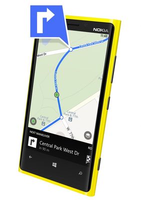
This is what Symbian and MeeGo have, but which was not done right away for the Windows Phone platform. So yes, there are three types of navigation in Nokia Maps - automobile, public transport and pedestrian. Traditionally, auto-navigation is made in a separate application called Nokia Drive. Navigation using public transport - in a separate application Nokia Transport. So, now in Nokia Maps for Windows Phone 8 there was also a navigation for pedestrians, which voiced key points, turns and street names in voice, while following a route.
It is also worth noting that pedestrian navigation is made in such a way as to lay walking routes, including through areas that are accessible only to pedestrians, such as parks, paths, footpaths, stairs, etc.

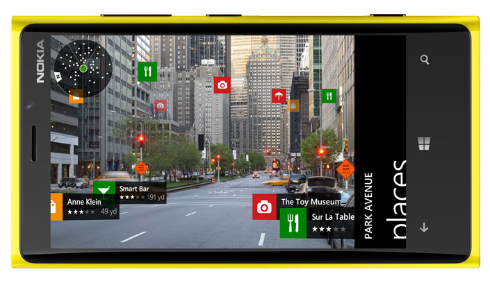
Augmented reality or augmented reality, this is what Nokia has planned for quite some time as an additional feature of Nokia Maps. As you can see in the picture, the augmented reality engine overlays map marks on the camera image. In you see on the screen in which direction this or that target or attraction is located. Together with pedestrian navigation, this looks like a very useful feature, especially for wandering around an unfamiliar city. It is worth saying that in this case, the compass is also included in the case, so it is not necessary to run back and forth, you can just spin around and look at the screen.
For Windows Phone 7 owners, Augmented Reality is available as a standalone Nokia City Lens application, which can be downloaded here.
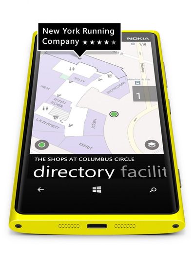
Another feature that has long been waiting in the wings at Nokia Labs. In the world it was known as indoor positioning, indoor navigation and eventually called venue maps. Very useful in large indoor areas where GPS reception is difficult or impossible, such as airports, shopping and business centers, stadiums, metro. This feature requires a radio infrastructure inside the building you are looking for. At a minimum, the infrastructure can be created based on existing WiFi networks. At most, you will need to install special WiFi and / or Bluetooth beacons.
Nokia Maps currently supports navigation inside more than 4,600 rooms in 38 countries, and new ones are added every month. Again, indoor navigation will be available for external applications as part of the Nokia Location Platform.

This is to remind you that this relatively new feature is inherited in the new Nokia Lumia. It consists in the fact that your constantly used routes are recorded automatically if you drove them more than two times, for example, from home to work. You can also set the route manually, as in the picture. For such routes, My Commute technology, an hour before the required time, calculates the travel time, taking into account traffic jams and other situations on the road, and tries to find an optimal alternative in time taking into account current circumstances.
With the release of Windows Phone 8, it was officially announced that this chip will be available in Germany, Russia, the UK and Brazil for several months. As for Russia, I have speculations that not all of Russia will fall under this business, but we will see what happens.
This is a slightly revised article by Pinot Bonetti, the original of which is here .
Offline Map Support
Offline maps are traditionally supported in WP8 along with other Nokia smartphones on other platforms such as Symbian and MeeGo. Those who prefer offline maps, note that they work faster and are cheaper, because you do not need to spend money on an Internet connection. In addition to these advantages, offline and online maps in WP8 can also be used by other, third-party applications through the corresponding API engine called Nokia Location Platform. This engine, which until recently existed as an API for JS (Web), JME (S40), Qt (Symbian & MeeGo), as well as in the form of REST services, is now available on Windows Phone 8 as a feature of the platform and in hybrid form - online and offline.
A distinctive feature in the Nokia Lumia 920 and 820- this is that they have autonomous A-GPS and A-GLONASS receivers installed . Existing Nokia phones with GPS suffer from the fact that offline mode in Nokia Maps disables A-GPS and as a result it takes a rather long time to wait until the device finds its current location. Now Lumia 920 and 820 promise the normal operation of A-GPS and offline including, that is, the location will be in a few seconds.
It should be added, for those who do not know that if the cards switch between offline and online modes, then all changes to offline maps received in online mode will remain in the cache after this mode is turned off.
Pedestrian navigation with voice prompts
This is what Symbian and MeeGo have, but which was not done right away for the Windows Phone platform. So yes, there are three types of navigation in Nokia Maps - automobile, public transport and pedestrian. Traditionally, auto-navigation is made in a separate application called Nokia Drive. Navigation using public transport - in a separate application Nokia Transport. So, now in Nokia Maps for Windows Phone 8 there was also a navigation for pedestrians, which voiced key points, turns and street names in voice, while following a route.
It is also worth noting that pedestrian navigation is made in such a way as to lay walking routes, including through areas that are accessible only to pedestrians, such as parks, paths, footpaths, stairs, etc.
Augmented Reality
Augmented reality or augmented reality, this is what Nokia has planned for quite some time as an additional feature of Nokia Maps. As you can see in the picture, the augmented reality engine overlays map marks on the camera image. In you see on the screen in which direction this or that target or attraction is located. Together with pedestrian navigation, this looks like a very useful feature, especially for wandering around an unfamiliar city. It is worth saying that in this case, the compass is also included in the case, so it is not necessary to run back and forth, you can just spin around and look at the screen.
For Windows Phone 7 owners, Augmented Reality is available as a standalone Nokia City Lens application, which can be downloaded here.
Indoor navigation
Another feature that has long been waiting in the wings at Nokia Labs. In the world it was known as indoor positioning, indoor navigation and eventually called venue maps. Very useful in large indoor areas where GPS reception is difficult or impossible, such as airports, shopping and business centers, stadiums, metro. This feature requires a radio infrastructure inside the building you are looking for. At a minimum, the infrastructure can be created based on existing WiFi networks. At most, you will need to install special WiFi and / or Bluetooth beacons.
Nokia Maps currently supports navigation inside more than 4,600 rooms in 38 countries, and new ones are added every month. Again, indoor navigation will be available for external applications as part of the Nokia Location Platform.
My commute
This is to remind you that this relatively new feature is inherited in the new Nokia Lumia. It consists in the fact that your constantly used routes are recorded automatically if you drove them more than two times, for example, from home to work. You can also set the route manually, as in the picture. For such routes, My Commute technology, an hour before the required time, calculates the travel time, taking into account traffic jams and other situations on the road, and tries to find an optimal alternative in time taking into account current circumstances.
With the release of Windows Phone 8, it was officially announced that this chip will be available in Germany, Russia, the UK and Brazil for several months. As for Russia, I have speculations that not all of Russia will fall under this business, but we will see what happens.