Google creates a panoramic service "Google SeaView"
This service will work in much the same way Google Street View works. Only of course, there will be no road markings, cars and people. This is because the project is dedicated to the Great Barrier Reef, which surrounds most of Australia's coast. It was because of the reefs that the coast of the continent was previously known as very dangerous - now sailors have troubles associated with reefs too. So, a new project of Google Corporation will allow you to create a panorama of the Great Barrier Reef, where the smallest detail will be visible - whether it be a fish or a piece of coral.
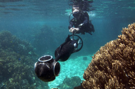
Within the framework of this project, special cameras will be involved that can operate at depths up to 100 meters. Photographers dressed in scuba gear are going to get about 50 thousand panoramic shots of both the reef and its inhabitants. Access to the database of photographs will be possible through Google Earth and Google Maps.
The title of the project, published in the title - “Google SeaView”, is not yet official, as some developers call it. Of course, the goals pursued by the Google team are quite clear. Firstly, it is a fixation of the development of coral reefs of the coast of Australia. In the future, it will be possible to compare data from future studies with the current picture. It is this comparison that will allow us to track the relationship between climate change and oceanic ecosystems.
In addition, the project provides for the creation of a clear map of the coast of Australia, indicating the smallest features. This is already necessary for sailors - they will have at their disposal accurate data on the basis of which it will be possible to create modern navigation maps. Now ships, especially tankers, are constantly in danger - at the slightest mistake of the captain, the ship may crash. And besides the ship itself and its crew, a complex ecosystem will suffer. We all know what a tanker accident can lead to.
Scientists of various specialties also have at their disposal the most valuable data with which it will be possible to work. In general, the project can be useful to many, thousands of specialists, and millions of people will enjoy viewing panoramas of ocean life.
Via dvice