The future of three-dimensional interfaces. Navigation
Students at MIT presented their future navigation interface design.
Known as AIDA 2.0, it is a concept of an interactive navigation system that tells the driving route, taking into account the usual roads, the need for refueling and other driving moments. AIDA 2.0 also includes a display of instrument indicators and a 3-dimensional map display directly in front of the driver, which adds clarity.
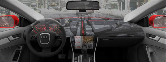
Given the trend of recent years regarding the improvement of 3-dimensional maps, the introduction of such a technology would be interesting.
In the meantime, this is just an interesting concept, for the implementation of which it is necessary to improve existing technologies and the accumulation of cartographic information.
Finally, I want to say that no system can replace good knowledge of roads.

Source:
www.smartplanet.com
Known as AIDA 2.0, it is a concept of an interactive navigation system that tells the driving route, taking into account the usual roads, the need for refueling and other driving moments. AIDA 2.0 also includes a display of instrument indicators and a 3-dimensional map display directly in front of the driver, which adds clarity.
Given the trend of recent years regarding the improvement of 3-dimensional maps, the introduction of such a technology would be interesting.
In the meantime, this is just an interesting concept, for the implementation of which it is necessary to improve existing technologies and the accumulation of cartographic information.
Finally, I want to say that no system can replace good knowledge of roads.
Source:
www.smartplanet.com