Digital elevation model - by the shadow of the clouds
 In the topographic survey, the shadow of objects is one of the main enemies, because they interfere with the normal recognition of images and subsequent mathematical calculations of the coordinates of objects. However, Nathan Jacobs and his fellow students from the University of Washington, Missouri found all the same useful application of "harmful" shadows. They developed a computer program that creates an accurate 3D map of the area in the shadows of the clouds.
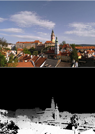
 3D terrain maps are usually generated using laser devices that measure the distance to a reflected object. It is almost impossible to create such a card with a conventional digital camera, because the distance to the objects and their shape cannot be recognized from the photograph. However, the movement of clouds and their shadows changes the situation.
An automatic system developed by Jacobs analyzes a series of consecutive photographs. The system captures the color change of each pixel and on the basis of this information calculates the real distance between the points. Knowing the wind speed, you can hammer the correct scale into the grid - and the result is a finished 3D-model of the terrain. According to the developers, the coordinate error does not exceed 2%, when compared with laser systems.
The presentation of scientific work ( PDF ) will take place tomorrow at the Computer Vision and Pattern Recognition conference in San Francisco.
via New Scientist