Look at DoubleGIS
Once upon a time, when I was still traveling to the institute by metro, an interesting and, as it turned out, mega-useful project DoubleGIS appeared in Novosibirsk . The concept of the project is simple: combine an electronic directory of enterprises with a map of the city and give people the opportunity to use such a reference map for free. The move turned out to be a win-win, and when the popularity of the project became such that even the Novosibirsk children began to move from the sandbox to the sandbox, guided by DublGIS, the project began to expand to other cities.
Today DublGIS is distributed in 16 cities of Russia and Ukraine. Moreover, the list of cities is constantly growing.
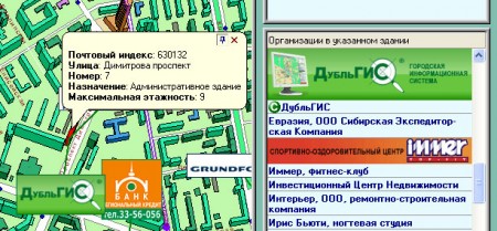
Of the distinguishing features from just directories or simply map services, one can note, firstly, the interactivity of the map, which makes it possible to click on any street, building or structure and get detailed information about the organizations in this building and its number of storeys. New buildings, by the way, are marked on the map in brown, so that they are easy to distinguish against the general background.
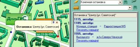
Secondly, it is worth noting transport routes. Moreover, the route can be viewed both by the parameters “initial stop” - “final stop”, and by clicking on the stop icon directly on the map. If there is no direct transport on the selected route, the program will calculate and offer options with transfers or foot crossings :)
In addition, in DublGIS you can calculate the distance, for example, from work to the nearest cafe; search directly on the map by street and house number, metro or railway station, district or housing estate. In the end, you can print the route from the airport to the hotel and feel free to go on a business trip to an unfamiliar city. By the way, a hotel should be selected in advance here, in the directory of organizations.
The multi-platform program gives complete freedom of choice: this is the PC and PDA version , and the online version . At the moment, a Java application for mobile phones and a mobile version of the program are being tested , and in January DublGIS will open with an open API .
So, if you are going on a business trip, just download DublGIS into your PDA or laptop and do not get distracted by questions to passers-by like “how to get to the library”. Moreover, in most cases you will still be answered “look at DublGIS”;)
Today DublGIS is distributed in 16 cities of Russia and Ukraine. Moreover, the list of cities is constantly growing.
Of the distinguishing features from just directories or simply map services, one can note, firstly, the interactivity of the map, which makes it possible to click on any street, building or structure and get detailed information about the organizations in this building and its number of storeys. New buildings, by the way, are marked on the map in brown, so that they are easy to distinguish against the general background.
Secondly, it is worth noting transport routes. Moreover, the route can be viewed both by the parameters “initial stop” - “final stop”, and by clicking on the stop icon directly on the map. If there is no direct transport on the selected route, the program will calculate and offer options with transfers or foot crossings :)
In addition, in DublGIS you can calculate the distance, for example, from work to the nearest cafe; search directly on the map by street and house number, metro or railway station, district or housing estate. In the end, you can print the route from the airport to the hotel and feel free to go on a business trip to an unfamiliar city. By the way, a hotel should be selected in advance here, in the directory of organizations.
The multi-platform program gives complete freedom of choice: this is the PC and PDA version , and the online version . At the moment, a Java application for mobile phones and a mobile version of the program are being tested , and in January DublGIS will open with an open API .
So, if you are going on a business trip, just download DublGIS into your PDA or laptop and do not get distracted by questions to passers-by like “how to get to the library”. Moreover, in most cases you will still be answered “look at DublGIS”;)