Drones can replace a surveyor at a construction site
Company Identified Technologies showed showed its automated system consisting of quadrocopter and robot base platform for its service. The complex, according to the creators, can be used for such work on a construction site, which usually requires the participation of a surveyor: measuring distances, areas, calculating the volume of earthwork and several other functions. The authors promise sub-centimeter measurement accuracy.
The principle of operation of the complex is primarily based on the operation of a quadrocopter, which flies over a construction site (or any other topographic object) and performs photogrammetric shooting. Creation and processing of models takes place in real time: an engineer visits a special site and sees the results of shooting without copying its files and processing them. All data is stored in file formats compatible with popular GIS programs.
Typically, the calculation of the volume of earthwork requires a surveyor for a lot of time. It is necessary to have a special marking of the pit or trench, determine the elevations of the characteristic points, and carry out the calculations. According to the authors of the development, the solution to this problem will require minimal action from the engineer - use the mouse to indicate the area on the construction plan and wait for the shooting to complete.
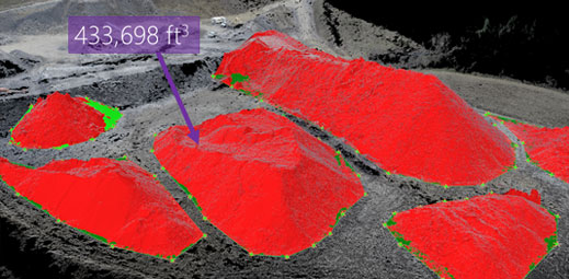
Calculation of the volume of earthwork, photo Identified Technologies
The complex can also be used for mapping areas, as well as monitoring the position of industrial facilities when their usual geodetic survey will be impossible. The price of the complex is still unknown.