The free MyShake app developed at the University of Berkeley lab turns your smartphone into a mini seismograph
Welcome to our readers on the iCover Blog Pages . Today we’ll talk about the free MyShake app developed at the University of California’s Seismology Laboratory at Berkeley. The application runs on the smartphone in the background and allows the user to pre-fix potentially dangerous seismic activity.
Destructive earthquakes in large cities have been and remain a global problem. The prevention of an earthquake even a minute before the first tangible shocks can provide residents of megacities with that precious temporary head start, which will make it possible to leave the confined space of an apartment or city transport and move to a safer place.
Modern earthquake early warning systems using a database of integrated seismic and geodetic networks today exist in several developed countries and find support at the federal level. So in July 2015, the US Geological Survey allocated $ 4 million to the Berkeley Seismological Laboratory to develop the ShakeAlert early warning system project for cities and transportation networks in the states of California, Oregon and Washington. At the same time, the density of stationary equipment offered by the system, despite the 400 (!) Existing seismological stations within the state of California and the prospect of implementing the ShakeAlert project, is still inferior to a similar indicator, say, in Japan, where seismic sensors provide information to central computers,
A simple and inexpensive way to solve the problem of eliminating "white spots" was proposed by a team of scientists at the University of Berkeley in California. As an alternative to a laboratory seismograph, it was proposed to use a smartphone available to the vast majority of us with built-in accelerometers. The result of the joint work of a group of specialists was a unique application of MyShake, which, according to the developers, is capable of collecting, analyzing, sending to a central node in combination with smartphone sensors and receiving confirmation of overcoming a dangerous seismic activity threshold. A detailed description of the development can be found on the pages of the online publication Science Advances .
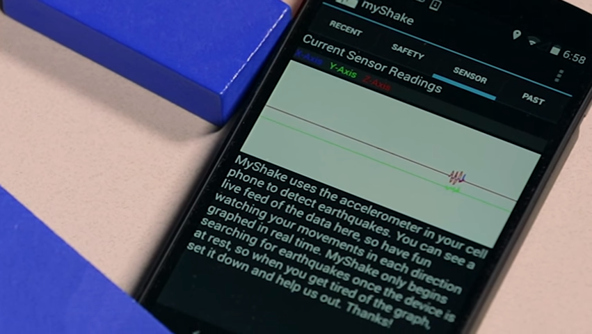
Researchers have shown that smartphone sensors are capable of detecting tremors, while separating useful information from “background noise” of various origins. The MyShake application allows you to turn your smartphone into a semblance of a miniature seismological station connected to a central node, where data from a global map of seismic activity are collected and analyzed. Thus, the application not only reads, analyzes information, but also translates useful data, including the user's GPS coordinates, to the Berkeley University seismology laboratory, where they are subjected to further centralized analysis based on which it is concluded that there is a real danger.
In turn, the data collected by thousands of smartphones within the global information network will provide a more accurate and comprehensive picture of global processes in the earth's crust in real time. In this case, the seismic signals collected by smartphones can be used to compile operational maps of seismic activity.
“Of course, the built-in complex of accelerometers and MyShake applications cannot replace traditional seismic networks, such as those managed by the US Geological Survey, the University of California at Berkeley or the University of Washington. At the same time, we believe that MyShake will increase the accuracy of earthquake prediction and predict it earlier where there is traditional seismic control, and where there is none, to become the only opportunity for early emergency warning, ”commented Professor Richard Allen (Richard Allen), MyShake Project Manager, Director of the Berkeley Seismology Laboratory. So, for example, a mobile seismological network of smartphones with a pre-installed application can become indispensable in developing countries with a seismic hazardous environment,
The accelerometer of the smartphone has sufficient sensitivity to fix the tremors lying motionless on a horizontal surface from 5 points, representing a real danger of destruction, at a distance of 10 km from the epicenter.
“We currently have a network of 400 seismic stations centered around San Francisco Bay and Los Angeles with its suburbs - one of the densest in the world and 16 million user smartphones within the state,” Allen said. “Even if we receive information only from a small part of the 16 million mobile devices participating in our program, we will be able to significantly increase the reliability of the data, filling very quickly the information gap that we could not fill earlier, while increasing the time early warning. "
Currently, the California integrated seismic network monitors subsoil movement throughout the state using underground seismometers. “Today, ShakeAlert alerts you to at least four of our traditional seismic stations,” says Allen. "... But if we have the data of mobile phones, it is likely that only one will be enough to make a decision on confirmation."
Work on the application code that allows you to interpret sensor data using an analysis algorithm and transfer the processing results to the servers of the University of Berkeley lasted for 3 years with the participation of a total of 8 developers. “When creating an application that is able to collect the necessary data in real time, we remembered that it would work in the background and should not have a noticeable effect on the operation of an average smartphone - block the handset, use the lion's share of the RAM resource or eat up battery power by connecting to a GPS receiver ”, - shared experience Louis Schreier (Louis Schreier), vice president of innovation center T-Labs, whose specialists participated in the development.

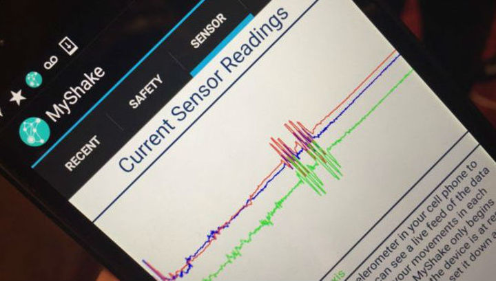
Algorithm testing was carried out in total with 75 Android - smartphones of students, colleagues and friends of the authors of the development using the vibration stands of the university laboratory, which allow to simulate earthquakes with a high degree of accuracy. The result looks very encouraging: the shocks simulating the earthquake profile on the vibration stand were separated from the characteristic background “vibration noise” with an accuracy of 93% and identified by the accelerometers of smartphones from previous years of production . (a fragment of the experiment is shown in the figure below).

The phone’s accelerometers monitor the seismic activity in real time, constantly checking the received data with the stored earthquake profiles. If they match, the operational data obtained, including the time, the amplitude of the shocks and the user's GPS coordinates in the form of a packet are sent to the server of the central seismological station in Berkeley, after which the GPS channel is deactivated. All data collected in the cloud of the central seismological station in Berkeley is also analyzed in real time. In the event that at least 4 smartphones with MyShake preinstalled transmitted similar information from the region and their number was 60% or more of the total number of application users within a radius of 10 km, the software algorithm confirms the earthquake by sending a notification to the user's smartphone.
“Today we issue a warning when critical information comes from at least four state seismic stations. - Allen comments on the situation with the early warning of an earthquake at the state of California. “If we can receive data from users’ smartphones, then perhaps one is enough for us to get an objective picture. ”
To accurately assess the location of the source of seismic activity, the estimated strength and time of shocks using the application data, information from at least 300 smartphones in a 110 x 110 km square will be required. Thus, the denser the network in a particular region, the earlier its users will receive an alert about an impending cataclysm. “With a sufficient network density, the entire process from detection to notification will take less than a second,” said Young-Woo Kwon, co-author of the invention from Utah State University in his publication .
It is worth noting that the ability to use the smartphone’s accelerometers to recognize seismological activity was already considered earlier, in April 2015, at the level of development of a group of specialists from the USA and Canada. But the result can hardly be called successful, since the proposed algorithm assumed the constant presence in the background of the GPS positioning option, which significantly lowers the device’s battery. The second drawback was the imperfection of the algorithm, which involves the preliminary processing of the data collected by the sensors at the level of the iOS or Android platform, rather than transferring them for analysis directly to a standalone smartphone application. Both points, ultimately, became the cornerstone that made the use of the proposed algorithm ineffective.
The MyShake application is devoid of the described shortcomings and, according to the results of preliminary testing, confirmed the expectations of specialists. Given that the application is distributed free of charge and practically does not create problems for the user, the developers sincerely hope that thousands of smartphone owners will install it, which will allow, in case of successful confirmation of the idea already at the level of a global experiment, to improve and update the application and the technology itself further. In the long term, according to the project curator Richard Allen, the application will be installed on most smartphones, which will allow you to get a unique global seismological network with the highest possible early warning capabilities for all active MyShake users.
“MyShake is primarily a seismic network for which we developed an early warning algorithm. Such a network can provide millions of seismic signals that will be useful in a wide range of research projects. They can, for example, be used to create specific detailed maps of microseismic activity, which, in turn, will be very useful in building design.
Read more: Science Advances , Eurekalert.org , phys.org .
From Friday February 12, 2016, from the date of publication on the Science Advances portal, the MyShake application is available for free download on Google Play . The next stage, planned by the Berkeley team, is the development of a variation of the free iPhone application.
Dear readers, we are always happy to meet and wait for you on the pages of our blog. We are ready to continue to share with you the latest news, review materials and other publications, and will try to do our best to make the time spent with us useful for you. And, of course, do not forget to subscribe to our columns . Our other articles and events

Destructive earthquakes in large cities have been and remain a global problem. The prevention of an earthquake even a minute before the first tangible shocks can provide residents of megacities with that precious temporary head start, which will make it possible to leave the confined space of an apartment or city transport and move to a safer place.
Modern earthquake early warning systems using a database of integrated seismic and geodetic networks today exist in several developed countries and find support at the federal level. So in July 2015, the US Geological Survey allocated $ 4 million to the Berkeley Seismological Laboratory to develop the ShakeAlert early warning system project for cities and transportation networks in the states of California, Oregon and Washington. At the same time, the density of stationary equipment offered by the system, despite the 400 (!) Existing seismological stations within the state of California and the prospect of implementing the ShakeAlert project, is still inferior to a similar indicator, say, in Japan, where seismic sensors provide information to central computers,
A simple and inexpensive way to solve the problem of eliminating "white spots" was proposed by a team of scientists at the University of Berkeley in California. As an alternative to a laboratory seismograph, it was proposed to use a smartphone available to the vast majority of us with built-in accelerometers. The result of the joint work of a group of specialists was a unique application of MyShake, which, according to the developers, is capable of collecting, analyzing, sending to a central node in combination with smartphone sensors and receiving confirmation of overcoming a dangerous seismic activity threshold. A detailed description of the development can be found on the pages of the online publication Science Advances .
Researchers have shown that smartphone sensors are capable of detecting tremors, while separating useful information from “background noise” of various origins. The MyShake application allows you to turn your smartphone into a semblance of a miniature seismological station connected to a central node, where data from a global map of seismic activity are collected and analyzed. Thus, the application not only reads, analyzes information, but also translates useful data, including the user's GPS coordinates, to the Berkeley University seismology laboratory, where they are subjected to further centralized analysis based on which it is concluded that there is a real danger.
In turn, the data collected by thousands of smartphones within the global information network will provide a more accurate and comprehensive picture of global processes in the earth's crust in real time. In this case, the seismic signals collected by smartphones can be used to compile operational maps of seismic activity.
“Of course, the built-in complex of accelerometers and MyShake applications cannot replace traditional seismic networks, such as those managed by the US Geological Survey, the University of California at Berkeley or the University of Washington. At the same time, we believe that MyShake will increase the accuracy of earthquake prediction and predict it earlier where there is traditional seismic control, and where there is none, to become the only opportunity for early emergency warning, ”commented Professor Richard Allen (Richard Allen), MyShake Project Manager, Director of the Berkeley Seismology Laboratory. So, for example, a mobile seismological network of smartphones with a pre-installed application can become indispensable in developing countries with a seismic hazardous environment,
The accelerometer of the smartphone has sufficient sensitivity to fix the tremors lying motionless on a horizontal surface from 5 points, representing a real danger of destruction, at a distance of 10 km from the epicenter.
“We currently have a network of 400 seismic stations centered around San Francisco Bay and Los Angeles with its suburbs - one of the densest in the world and 16 million user smartphones within the state,” Allen said. “Even if we receive information only from a small part of the 16 million mobile devices participating in our program, we will be able to significantly increase the reliability of the data, filling very quickly the information gap that we could not fill earlier, while increasing the time early warning. "
How it works
Currently, the California integrated seismic network monitors subsoil movement throughout the state using underground seismometers. “Today, ShakeAlert alerts you to at least four of our traditional seismic stations,” says Allen. "... But if we have the data of mobile phones, it is likely that only one will be enough to make a decision on confirmation."
Work on the application code that allows you to interpret sensor data using an analysis algorithm and transfer the processing results to the servers of the University of Berkeley lasted for 3 years with the participation of a total of 8 developers. “When creating an application that is able to collect the necessary data in real time, we remembered that it would work in the background and should not have a noticeable effect on the operation of an average smartphone - block the handset, use the lion's share of the RAM resource or eat up battery power by connecting to a GPS receiver ”, - shared experience Louis Schreier (Louis Schreier), vice president of innovation center T-Labs, whose specialists participated in the development.
Algorithm testing was carried out in total with 75 Android - smartphones of students, colleagues and friends of the authors of the development using the vibration stands of the university laboratory, which allow to simulate earthquakes with a high degree of accuracy. The result looks very encouraging: the shocks simulating the earthquake profile on the vibration stand were separated from the characteristic background “vibration noise” with an accuracy of 93% and identified by the accelerometers of smartphones from previous years of production . (a fragment of the experiment is shown in the figure below).
The phone’s accelerometers monitor the seismic activity in real time, constantly checking the received data with the stored earthquake profiles. If they match, the operational data obtained, including the time, the amplitude of the shocks and the user's GPS coordinates in the form of a packet are sent to the server of the central seismological station in Berkeley, after which the GPS channel is deactivated. All data collected in the cloud of the central seismological station in Berkeley is also analyzed in real time. In the event that at least 4 smartphones with MyShake preinstalled transmitted similar information from the region and their number was 60% or more of the total number of application users within a radius of 10 km, the software algorithm confirms the earthquake by sending a notification to the user's smartphone.
“Today we issue a warning when critical information comes from at least four state seismic stations. - Allen comments on the situation with the early warning of an earthquake at the state of California. “If we can receive data from users’ smartphones, then perhaps one is enough for us to get an objective picture. ”
To accurately assess the location of the source of seismic activity, the estimated strength and time of shocks using the application data, information from at least 300 smartphones in a 110 x 110 km square will be required. Thus, the denser the network in a particular region, the earlier its users will receive an alert about an impending cataclysm. “With a sufficient network density, the entire process from detection to notification will take less than a second,” said Young-Woo Kwon, co-author of the invention from Utah State University in his publication .
It is worth noting that the ability to use the smartphone’s accelerometers to recognize seismological activity was already considered earlier, in April 2015, at the level of development of a group of specialists from the USA and Canada. But the result can hardly be called successful, since the proposed algorithm assumed the constant presence in the background of the GPS positioning option, which significantly lowers the device’s battery. The second drawback was the imperfection of the algorithm, which involves the preliminary processing of the data collected by the sensors at the level of the iOS or Android platform, rather than transferring them for analysis directly to a standalone smartphone application. Both points, ultimately, became the cornerstone that made the use of the proposed algorithm ineffective.
The MyShake application is devoid of the described shortcomings and, according to the results of preliminary testing, confirmed the expectations of specialists. Given that the application is distributed free of charge and practically does not create problems for the user, the developers sincerely hope that thousands of smartphone owners will install it, which will allow, in case of successful confirmation of the idea already at the level of a global experiment, to improve and update the application and the technology itself further. In the long term, according to the project curator Richard Allen, the application will be installed on most smartphones, which will allow you to get a unique global seismological network with the highest possible early warning capabilities for all active MyShake users.
“MyShake is primarily a seismic network for which we developed an early warning algorithm. Such a network can provide millions of seismic signals that will be useful in a wide range of research projects. They can, for example, be used to create specific detailed maps of microseismic activity, which, in turn, will be very useful in building design.
Read more: Science Advances , Eurekalert.org , phys.org .
From Friday February 12, 2016, from the date of publication on the Science Advances portal, the MyShake application is available for free download on Google Play . The next stage, planned by the Berkeley team, is the development of a variation of the free iPhone application.
Dear readers, we are always happy to meet and wait for you on the pages of our blog. We are ready to continue to share with you the latest news, review materials and other publications, and will try to do our best to make the time spent with us useful for you. And, of course, do not forget to subscribe to our columns . Our other articles and events