Between space and the Internet
A couple of weeks ago I wrote about solar eclipses from the Electro-L satellite. The material unexpectedly gained a large number of positive reviews, but I realized a simple thing: for all the skepticism with which the Russian cosmonautics is accepted on the Internet, people are ready to be proud of domestic achievements, if they really are. For many, the opening was photos of Electro-L, and for a scientific center receiving satellite images, the opening was the interest with which people rushed to the site and began to download the posted photos.
Just a week later, I had the opportunity to visit the Scientific Center for Operational Monitoring of the Earth (NTZ OMZ) and simultaneously find out how photos from Russian satellites get on the Internet.
True, the visit took place without a camera: the shooting must be separately agreed upon at Roskosmos, and this is a long business, with an uncertain outcome. Therefore, I had to be content with what I took off the street and the photographs provided at the Center .
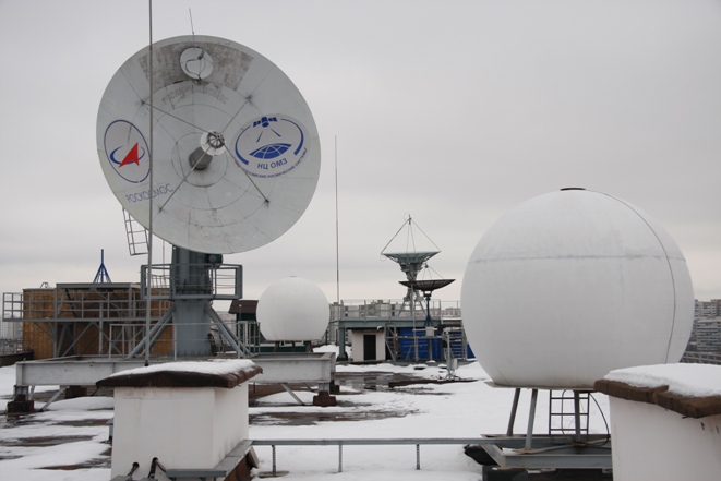
The NTZ OMZ in Moscow is located between the Otradnoye and Botanical Garden metro stations. From a distance, the dishes of radio antennas located on the roof of a ten-story building are already attracting attention, inspiring space moods among the gray concrete of the sleeping area of the capital.
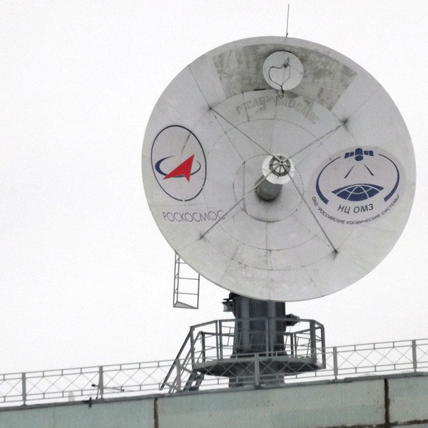
Actually with the "plates" and began my acquaintance with the Center. On the roof I was shown several antennas that differ in diameter and the ability to track the passing satellites. The largest plate is 7 m, the rest are smaller - 2.5-5 meters.
"Electro-L" is located in a geostationary orbit, therefore, to receive its signals, a fixed antenna directed towards the device is enough.

The information is received on a 2.5-meter antenna of its own design, NTs OMZ, which provides reception at a frequency of 7.5 GHz with a speed of 30.72 Mbit / s eliminating any atmospheric interference (the antenna complex itself allows receiving information at a speed of up to 300 Mbit / s and not only from geostationary satellites). For all users, the satellite broadcasts information in the 1.7 GHz band in the HRIT / LRIT format, and it can be received with three-meter plates. Everyone can do it.who has a suitable antenna, only equipment decoding the format is needed. That is, the results of the satellite are not encrypted and are available in almost the entire hemisphere, which it just takes
For the effect of complete sticking and relaxation: 7-minute version
Other satellites fly by quite quickly and require tracking in order to merge all the information.
In addition to Electra, NTs OMZ receives data from the ISS and from the Resurs-DK1, Kanopus-V, BKA, Meteor-M, MKA-FKI, Terra, Aqua, NOAA satellites. The last three are foreign meteorological satellites, information from which is accessible to everyone. The BKA is formally also foreign - the “Belarusian Spacecraft” - although, in fact, it is a clone of our Canopus-V, which flies with it in the same orbit with a difference of 180 degrees and operates in a single complex.

For Internet users who like beautiful pictures with high detail, the most interesting of Russian technology are Resource - DK1 and Canopus-V (BKA). They shoot with a resolution of up to 2.1 m per pixel. From civil space technology - this is our domestic limit. The military may have something more detailed, but, of course, there is no access to it. Although 2.1 m / pix is already behind the same Goole Map and, in some places, Yandex Maps, the value of such a survey is repeatable. That is, it is possible to track not only the current state of objects on the surface, but also, comparing with previous images, assess the degree of change. Such observations are important in the event of natural disasters such as fires or floods. In addition, you can monitor the status of water bodies, forests, glaciers, monitor the ice situation in the seas and rivers.

Meteor-M has a low resolution limit of 50 m per pixel. Its results are more relevant specifically for meteorologists or the Ministry of Emergencies. When we entered the Information Receiving Complex , the image from the flying Meteor came directly to the screens.

As they explained to me: “this is not a bug - this is a feature” the technology has been developed by the NTs OMZ. The satellite was intended for shooting, accumulating and transmitting information, and they learned to use it as an orbital webcam while there is a direct connection with the Center. On other monitors, the satellite’s position is monitored, telemetry is broadcast, a separate screen shows the position of the antenna on the roof, which monitors the device. The reception complex is located on the 10th floor - closest to space. From there, the pictures go to Processing Complexeswhere a full technological cycle of data preparation for further use is carried out.

At the end of this stage, the materials are archived on magnetic films and sent to an automated tape library, where they are stored without statute of limitations.

After backup, the pictures are taken to the thematic processing complex , which provides monitoring of land use, forests and fires, environmental and geological monitoring, seismic forecast. A complex of interaction with consumers provides information to specific customers.

Seismic forecasting is a special topic. It seems that only the consequences of an earthquake can be seen from a satellite: destruction, cracks, landslides, etc. But it turned out not only. You can even predict with a probability of 90%, an accuracy of 0.2 points and three / two / one week. How this is done, I will tell separately it is too complicated and at the same time simple to try to explain in a nutshell.

For "Electro-L" has its own operator. The purpose of the satellite is to provide information promptly, so the Reception Complex is immediately involved in processing the images and sending them to the user - Roshydromet and directly to the network, that is, for us, to an open FTP server .

On the server, full-size photographs are in archives in two formats: JPEG and L15. Each archive contains 11 files. 1,2,3 are RGB channels, 4-10 are different infrared ranges, and the 11th is a combined color shot. With the "jeep" it is clear, and L15 is a "secret" format available only to meteorologists. There is no software on the network that allows you to open and view it. True, I was assured that from the point of view of the picture, it’s the same there as in JPEG, and the additional information is just text - all sorts of things, heights, temperatures, speeds ...
After looking at the pictures from Electro-L, you can see that the entire field of view outside the Earth’s disk is artificially blocked. At first, I thought that this was done mechanically - there was a hood in the camera that cuts off the extra third-party illumination.

But they explained to me that this is not so. The dark background is superimposed programmatically, at the stage of automatic processing. Satellite images are received in the L10 format (logically, these are L1.0 and L1.5, but in the format name there are no dots). It still has a lot of digital noise, all sorts of artifacts and inconsistencies between the two halves of the frame are visible. The fact is that the device that takes the pictures: MSU-GS (multizone scanning device for hydrometeorological support) is not a camera and it does not have a matrix.

This is a scanner that has two scanning CCD arrays that pass through their field of view, making up two halves of the future image. Rough combining of the halves is still carried out on the satellite, and processing and finishing mixing in the Information Receiving Complex at the stage from L10 to L15.
In L10, you can see space in the pictures. True, apart from the Moon and the Sun, nothing can be seen there, because the pictures are taken at a fast shutter speed, even the night light of megalopolises is not visible on them, not to mention the stars. Such dark pictures were taken deliberately, this allows to exclude the flare in white clouds and to reveal their multi-level structure. At my request, we were found pictures in L10, which hit the moon, transferred to tiff and uploaded to the FTP server - the archive " Luna.rar ". It is hoped that comets ISON and PANSTARRS , which are expected this year, will be bright enough to get on footage of Electro-L. Last - in three weeks it will arrive. If the employees of the NTs OMZ are as kind as in the case of the Moon, then we will see comets in an unusual, in fact, unique perspective.

Design on the desktop on the theme “ Earth and the Moon from Electro-L ”
When the previous article about our satellites was discussed, the comments drew attention to the large number of gray-haired heads in the group picture of Radioastron.

Like, space is aging, but there is no replacement.
Walking around the OMZ Scientific Center, I noted that, probably, at least 60% of all the employees met were under the age of 40, and many 30 years. The monitoring center has nothing to do with Radioastron, but my observation: as an illustration of the situation in the modern space industry. In general, the impressions of the Center remained very optimistic: the equipment is modern, the team is young and enthusiastic. At first glance, there is no difference from the usual office center: the same girls-designers, the same servers, the same motivating posters with company products on the walls, the same jokes in the smoking room on the stairs, but every morning all employees going to work have plates on the roof remind that this office is just space. At some point, associations with the working atmosphere of "Monday begins on Saturday" surfaced by the Strugatsky.
However, as soon as the nose was pushed out of the competence of the Monitoring Center, it was necessary to return to the current "Roskosmos" realities. The legacy of the military tradition and the heavy bureaucratic apparatus affected when it came to the idea of removing the span of the asteroid 2012 DA14 .

An asteroid flew on February 15 inside the ring of geostationary satellites at a distance of about 27 thousand km from Earth and 9 thousand km from satellites.
Moreover, its trajectory passed in the field of view of the Electro-L satellite.

The distance and size of the asteroid, in theory, excluded the possibility of observation: the body diameter is 50 m, and the satellite resolution at this distance is about 250 m / pixel. But there was a modest hope if the conditions for shooting and lighting were successfully formed. In any case, it would seem "attempt is not torture." INThe satellite’s technical specifications indicate that the survey frequency can be increased from normal 30 min / frame to 15 min / frame. But in fact, in order to do this, it is necessary to go through a whole chain of approvals: from the camera developer - Russian Space Systems OJSC, to Roshydromet end-user, only after the approval of both of them, contact the MCC to adjust the operation mode there. In our system, it was impossible to do this in three days.
And most importantly, how to explain why all this? There is no scientific value, but the argument "It's cool!" for all responsible persons will not work. Designers are worried, as if something had not been revealed during the extreme, albeit provided by the design, operating modes. Roshydromet generally offended by Electro-L for qualitytherefore, it makes no sense to him to make any efforts to popularize his work. Even no one understood and did not make calculations whether it is possible to remove an asteroid. The principle "If it works, then do not touch anything" reigns over everything. As a result, darkness:

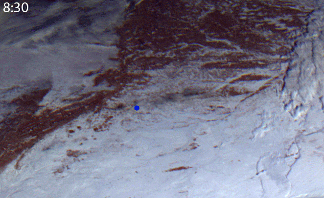
A similar story repeated 3 days later when the car collapsed in Chelyabinsk. Whoever understood the pictures on open FTP noticed that for every day there are no frames from 6:30 to 8:00. This happens not because of the fact that they are hiding, but because the pictures are not taken by the OMZ in Moscow, but by the Novosibirsk branch of Roshydromet. It accepts and holds. A car in Chelyabinsk flew at 7:20, that is, its footprint in the sky should be clearly visible in the pictures at 7:30. The Europeans made a fuss, checked their frames and, literally a few hours after the fall, media around the world circled the images of the satellites Meteosat-9 and Meteosat-10.

"Electro-L" also took off! Where are the frames? And the shots in the Novosibirsk hydromet are on the shelf. "Write a written appeal, send it to the address of the official reception, we will consider your request. There is no online service, we accept only paper . ” In short, bite , the Internet, no asteroid, no meteorite. About the Russian satellites in the news they will tell you when again some will fall!
In the pictures for 8: 30-9: 30, only the shadow of the scattered meteorite track was already visible. Although the angle was more successful than the Europeans.
According to Electro-L, the specialists of the Scientific Center were asked a lot of questions, some of them did not even cope and redirected to the developer. I think I will prepare a detailed technical review on the satellite a little later, when there is enough information. If now what questions arise, let's leave a branch for this in the comments, I will try to find the answers.

Photo and video processing of satellite images was carried out by members of the Electro-L Vkontakte community .
Just a week later, I had the opportunity to visit the Scientific Center for Operational Monitoring of the Earth (NTZ OMZ) and simultaneously find out how photos from Russian satellites get on the Internet.
True, the visit took place without a camera: the shooting must be separately agreed upon at Roskosmos, and this is a long business, with an uncertain outcome. Therefore, I had to be content with what I took off the street and the photographs provided at the Center .
The NTZ OMZ in Moscow is located between the Otradnoye and Botanical Garden metro stations. From a distance, the dishes of radio antennas located on the roof of a ten-story building are already attracting attention, inspiring space moods among the gray concrete of the sleeping area of the capital.
Actually with the "plates" and began my acquaintance with the Center. On the roof I was shown several antennas that differ in diameter and the ability to track the passing satellites. The largest plate is 7 m, the rest are smaller - 2.5-5 meters.
"Electro-L" is located in a geostationary orbit, therefore, to receive its signals, a fixed antenna directed towards the device is enough.
The information is received on a 2.5-meter antenna of its own design, NTs OMZ, which provides reception at a frequency of 7.5 GHz with a speed of 30.72 Mbit / s eliminating any atmospheric interference (the antenna complex itself allows receiving information at a speed of up to 300 Mbit / s and not only from geostationary satellites). For all users, the satellite broadcasts information in the 1.7 GHz band in the HRIT / LRIT format, and it can be received with three-meter plates. Everyone can do it.who has a suitable antenna, only equipment decoding the format is needed. That is, the results of the satellite are not encrypted and are available in almost the entire hemisphere, which it just takes
For the effect of complete sticking and relaxation: 7-minute version
Other satellites fly by quite quickly and require tracking in order to merge all the information.
In addition to Electra, NTs OMZ receives data from the ISS and from the Resurs-DK1, Kanopus-V, BKA, Meteor-M, MKA-FKI, Terra, Aqua, NOAA satellites. The last three are foreign meteorological satellites, information from which is accessible to everyone. The BKA is formally also foreign - the “Belarusian Spacecraft” - although, in fact, it is a clone of our Canopus-V, which flies with it in the same orbit with a difference of 180 degrees and operates in a single complex.
For Internet users who like beautiful pictures with high detail, the most interesting of Russian technology are Resource - DK1 and Canopus-V (BKA). They shoot with a resolution of up to 2.1 m per pixel. From civil space technology - this is our domestic limit. The military may have something more detailed, but, of course, there is no access to it. Although 2.1 m / pix is already behind the same Goole Map and, in some places, Yandex Maps, the value of such a survey is repeatable. That is, it is possible to track not only the current state of objects on the surface, but also, comparing with previous images, assess the degree of change. Such observations are important in the event of natural disasters such as fires or floods. In addition, you can monitor the status of water bodies, forests, glaciers, monitor the ice situation in the seas and rivers.
Meteor-M has a low resolution limit of 50 m per pixel. Its results are more relevant specifically for meteorologists or the Ministry of Emergencies. When we entered the Information Receiving Complex , the image from the flying Meteor came directly to the screens.
As they explained to me: “this is not a bug - this is a feature” the technology has been developed by the NTs OMZ. The satellite was intended for shooting, accumulating and transmitting information, and they learned to use it as an orbital webcam while there is a direct connection with the Center. On other monitors, the satellite’s position is monitored, telemetry is broadcast, a separate screen shows the position of the antenna on the roof, which monitors the device. The reception complex is located on the 10th floor - closest to space. From there, the pictures go to Processing Complexeswhere a full technological cycle of data preparation for further use is carried out.
At the end of this stage, the materials are archived on magnetic films and sent to an automated tape library, where they are stored without statute of limitations.
After backup, the pictures are taken to the thematic processing complex , which provides monitoring of land use, forests and fires, environmental and geological monitoring, seismic forecast. A complex of interaction with consumers provides information to specific customers.
Seismic forecasting is a special topic. It seems that only the consequences of an earthquake can be seen from a satellite: destruction, cracks, landslides, etc. But it turned out not only. You can even predict with a probability of 90%, an accuracy of 0.2 points and three / two / one week. How this is done, I will tell separately it is too complicated and at the same time simple to try to explain in a nutshell.
For "Electro-L" has its own operator. The purpose of the satellite is to provide information promptly, so the Reception Complex is immediately involved in processing the images and sending them to the user - Roshydromet and directly to the network, that is, for us, to an open FTP server .
On the server, full-size photographs are in archives in two formats: JPEG and L15. Each archive contains 11 files. 1,2,3 are RGB channels, 4-10 are different infrared ranges, and the 11th is a combined color shot. With the "jeep" it is clear, and L15 is a "secret" format available only to meteorologists. There is no software on the network that allows you to open and view it. True, I was assured that from the point of view of the picture, it’s the same there as in JPEG, and the additional information is just text - all sorts of things, heights, temperatures, speeds ...
After looking at the pictures from Electro-L, you can see that the entire field of view outside the Earth’s disk is artificially blocked. At first, I thought that this was done mechanically - there was a hood in the camera that cuts off the extra third-party illumination.
But they explained to me that this is not so. The dark background is superimposed programmatically, at the stage of automatic processing. Satellite images are received in the L10 format (logically, these are L1.0 and L1.5, but in the format name there are no dots). It still has a lot of digital noise, all sorts of artifacts and inconsistencies between the two halves of the frame are visible. The fact is that the device that takes the pictures: MSU-GS (multizone scanning device for hydrometeorological support) is not a camera and it does not have a matrix.
This is a scanner that has two scanning CCD arrays that pass through their field of view, making up two halves of the future image. Rough combining of the halves is still carried out on the satellite, and processing and finishing mixing in the Information Receiving Complex at the stage from L10 to L15.
In L10, you can see space in the pictures. True, apart from the Moon and the Sun, nothing can be seen there, because the pictures are taken at a fast shutter speed, even the night light of megalopolises is not visible on them, not to mention the stars. Such dark pictures were taken deliberately, this allows to exclude the flare in white clouds and to reveal their multi-level structure. At my request, we were found pictures in L10, which hit the moon, transferred to tiff and uploaded to the FTP server - the archive " Luna.rar ". It is hoped that comets ISON and PANSTARRS , which are expected this year, will be bright enough to get on footage of Electro-L. Last - in three weeks it will arrive. If the employees of the NTs OMZ are as kind as in the case of the Moon, then we will see comets in an unusual, in fact, unique perspective.
Design on the desktop on the theme “ Earth and the Moon from Electro-L ”
When the previous article about our satellites was discussed, the comments drew attention to the large number of gray-haired heads in the group picture of Radioastron.
Like, space is aging, but there is no replacement.
Walking around the OMZ Scientific Center, I noted that, probably, at least 60% of all the employees met were under the age of 40, and many 30 years. The monitoring center has nothing to do with Radioastron, but my observation: as an illustration of the situation in the modern space industry. In general, the impressions of the Center remained very optimistic: the equipment is modern, the team is young and enthusiastic. At first glance, there is no difference from the usual office center: the same girls-designers, the same servers, the same motivating posters with company products on the walls, the same jokes in the smoking room on the stairs, but every morning all employees going to work have plates on the roof remind that this office is just space. At some point, associations with the working atmosphere of "Monday begins on Saturday" surfaced by the Strugatsky.
However, as soon as the nose was pushed out of the competence of the Monitoring Center, it was necessary to return to the current "Roskosmos" realities. The legacy of the military tradition and the heavy bureaucratic apparatus affected when it came to the idea of removing the span of the asteroid 2012 DA14 .
An asteroid flew on February 15 inside the ring of geostationary satellites at a distance of about 27 thousand km from Earth and 9 thousand km from satellites.
Moreover, its trajectory passed in the field of view of the Electro-L satellite.
The distance and size of the asteroid, in theory, excluded the possibility of observation: the body diameter is 50 m, and the satellite resolution at this distance is about 250 m / pixel. But there was a modest hope if the conditions for shooting and lighting were successfully formed. In any case, it would seem "attempt is not torture." INThe satellite’s technical specifications indicate that the survey frequency can be increased from normal 30 min / frame to 15 min / frame. But in fact, in order to do this, it is necessary to go through a whole chain of approvals: from the camera developer - Russian Space Systems OJSC, to Roshydromet end-user, only after the approval of both of them, contact the MCC to adjust the operation mode there. In our system, it was impossible to do this in three days.
And most importantly, how to explain why all this? There is no scientific value, but the argument "It's cool!" for all responsible persons will not work. Designers are worried, as if something had not been revealed during the extreme, albeit provided by the design, operating modes. Roshydromet generally offended by Electro-L for qualitytherefore, it makes no sense to him to make any efforts to popularize his work. Even no one understood and did not make calculations whether it is possible to remove an asteroid. The principle "If it works, then do not touch anything" reigns over everything. As a result, darkness:
A similar story repeated 3 days later when the car collapsed in Chelyabinsk. Whoever understood the pictures on open FTP noticed that for every day there are no frames from 6:30 to 8:00. This happens not because of the fact that they are hiding, but because the pictures are not taken by the OMZ in Moscow, but by the Novosibirsk branch of Roshydromet. It accepts and holds. A car in Chelyabinsk flew at 7:20, that is, its footprint in the sky should be clearly visible in the pictures at 7:30. The Europeans made a fuss, checked their frames and, literally a few hours after the fall, media around the world circled the images of the satellites Meteosat-9 and Meteosat-10.
"Electro-L" also took off! Where are the frames? And the shots in the Novosibirsk hydromet are on the shelf. "Write a written appeal, send it to the address of the official reception, we will consider your request. There is no online service, we accept only paper . ” In short, bite , the Internet, no asteroid, no meteorite. About the Russian satellites in the news they will tell you when again some will fall!
In the pictures for 8: 30-9: 30, only the shadow of the scattered meteorite track was already visible. Although the angle was more successful than the Europeans.
According to Electro-L, the specialists of the Scientific Center were asked a lot of questions, some of them did not even cope and redirected to the developer. I think I will prepare a detailed technical review on the satellite a little later, when there is enough information. If now what questions arise, let's leave a branch for this in the comments, I will try to find the answers.
Photo and video processing of satellite images was carried out by members of the Electro-L Vkontakte community .