Curiosity at the bottom
Finally, NASA shared the results of the Curiosity study for December and half of January. And for the purpose of drilling, it was also determined. The main summary of the news: almost all the minerals that now surround the rover are formed with the participation of water. That is, in fact, it is at the bottom of the former ancient Martian reservoir.

Only two meters drove Curiosity from the moment he tested his brush in action. Since then, in a week he has sent so many things that amaze, surprise or baffle that it’s just right to say “do not cook the pot”. But he continues right now, and this is Mars, so "go on with the pot."
First things first.
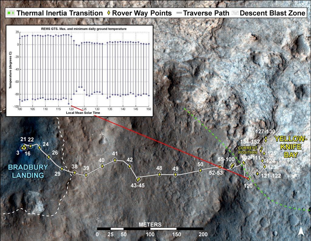
About a month ago, Curiosity came to a new type of surface of Mars, which was characterized by high thermal inertia. This means that it heats up more slowly and cools more slowly, which indicates a high density of the rock. (Read more about the geology of Gale Crater habrahabr.ru/post/162567 )

(The lilac section is with high thermal inertia. The cross is the landing site, the red dots are the driving route .)
Then the landscapes changed, and powerful stone slabs covered under the wheels of the rover went cracks:

Even then, for similarity to a pond, the place was called Yellowknifle Bay (Yellowknife Bay, a town in Canada).
The analysis of the REMS airborne climate station showed that the temperature indicators of the soil really changed:
The result of 120 sols was especially noted when the rover approached the third type of Glenelg surface, which will be studied later. The site, called Shaler, attracted attention with its unusual layered structure:
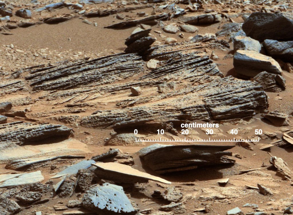
According to NASA geologists, it is also formed by water, but unlike Yellowknifle Bay, a stream of water worked here, and not a standing reservoir.
The lower flat part - the “bottom” of the bay - is surrounded by a low threshold, which differs in its material from the bottom:
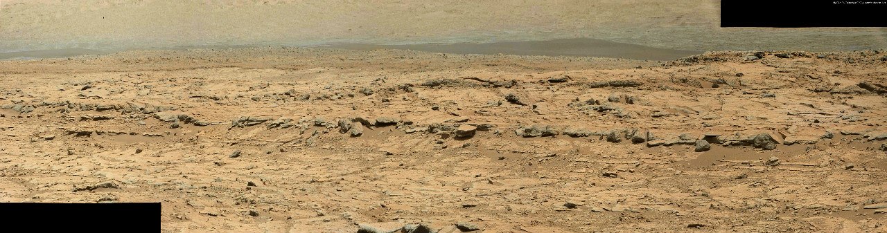
Curiosity proceeded to study the “floor” and “threshold”:

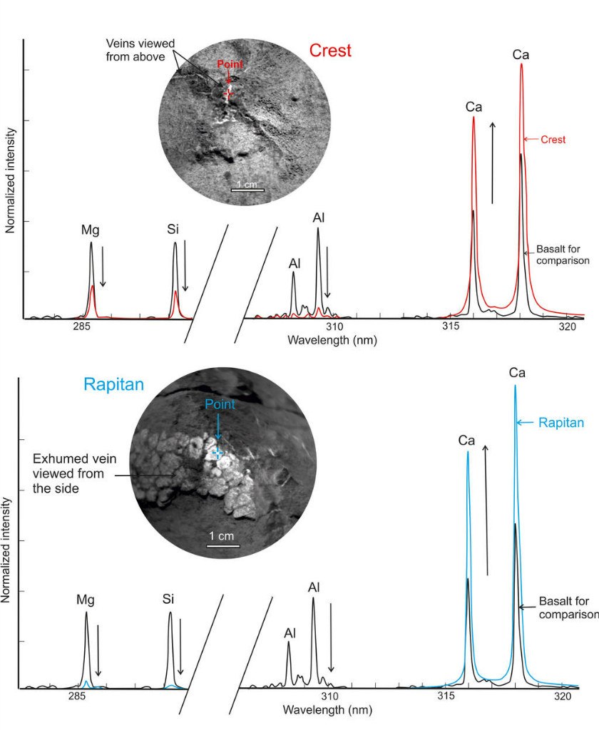
Characteristic white veins were immediately noticed that penetrated almost all the cracks in the lowland. Veins are marked with white arrows, small mineral nodules are marked with black arrows. Geologists know similar veins on Earth, but Martian ones were carefully analyzed:
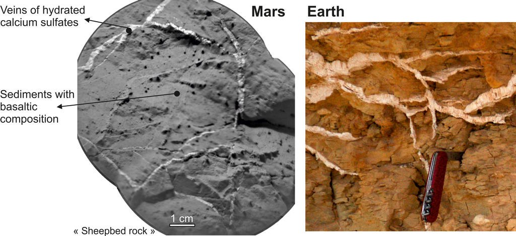
The result was quite expected - this is hydrated calcium sulfate, most likely in the mineral form of gypsum. Calcium sulfate is found in Yellowknifle Bay in two forms: veins and “nodules”. Veins form at moderate temperatures when water saturated with sulfur and calcium circulates through cracks between the stones. That is, unambiguously at a certain period of time there was liquid water, and so long that it managed to hammer in all the cracks with plaster.
In addition to plaster cores, there are also plaster "nodules":

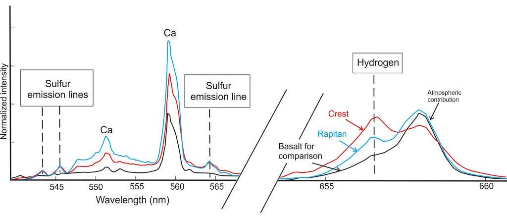
NASA shared the results of spectral analyzes of one core (Crest) and "nodules" (Rapitan) with the public:
Since gypsum is a mineral that binds water, there should be an increase in the concentration of hydrogen in the soil. That is, in an interesting direction, the results of the readings of the DAN device should change. They have not yet been made public, but hydrogen is also determined with the help of ChemCam:
Balls were found in the bottom. In general, balls on Mars are not a deficit. Opporutnity found two types that were completely different in the structure, material, and origin of the balls. Now Curiosity has begun to replenish its collection:

According to NASA geologists, these are mineral nodules that form in the bottom layer of a reservoir. Below are already basaltic rocks, which probably remember the asteroid that gave rise to the Gale crater.
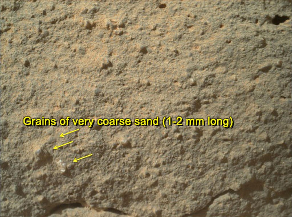
The stone “threshold” is also formed with the participation of water, but in completely different conditions. It is a cemented sandstone mixed with larger granules of various minerals. Journalists nicknamed one of these 2 mm granules, most likely quartz, the “Martian flower.” (About this story in more detail here: habrahabr.ru/post/164759 ).
Curiosity has already been approaching the “threshold” several times, but has taken up serious study only now:

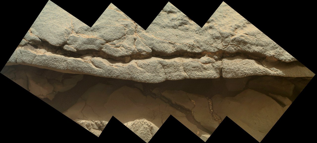
In general, he chose a surprisingly rich place to study. The "threshold" was not easy. As can be seen in the photographs of the general plan, a longitudinal crack cuts it:

Just yesterday, the rover looked into it and showed that it was not simple, but with a “filling”:
However, the most interesting was found earlier:
This is the most natural petrified mud on Mars. The scale (the wide side of the image is approximately 7-10 cm) allows us to state that nothing but small mineral particles with water could form such incrustations. NASA characterizes this breed as «siltstone» - «yl petrified", although the term "used in geology silts ".
The day before yesterday, when NASA had not yet talked about the results of research, the news “Curiosity found fossilized dirt on Mars” was worthy of the front pages of the yellow newspapers, but even it faded when the next batch of images came:
This is a mosaic of ChemCam photos that reveals a foam- like texture . In the photo of mast cameras, this layer is not so expressive:

Well, it consists, as we now know, of gypsum “knots”, so it is unlikely that NASA will pay more attention to it than it can do it remotely. Although the process of its formation is in question. According to one version, these were gypsum granules that were flooded with the same “dirt”; according to another, it was a porous rock like pumice, in which gypsum accumulated in the same way as in cracks.
Now, finally, about where will Suriosity drill.
The place called "John Klein" is at the bottom. I thought they would choose sandstone for security reasons, but they preferred a place that was more promising from a scientific point of view.
It looks like a dry puddle, where the dirt cracked on the plates and rose up. They identified three sites that we would like to draw our attention to. Square "A" stands for "veins like ridges" - a type of crack that is characteristic only for this geological layer. “B” indicates the layered nature of the surface, that is, a 5 cm drill can pass through several thin layers, which is more interesting for research. Section “C” is highlighted to draw attention to a crack that is not filled with anything and can be a larger fracture that goes out in depth.
More details can be seen on the panorama of the GigaPan .
Now a small conclusion. Yes, there was water on Mars, there was a lot of it, and these are not sporadic short-term spills caused by meteorites or volcanoes. Streams formed pebbles, accumulated "sludge" and precipitated solutes at the bottom. But there is no novelty in these facts. Opportunity found the same thing, with the possible exception of only pebbles. And gypsum and other minerals formed by water are in his piggy bank. The fact is that all these are traces of water that flowed on Mars during the Hesperides. When powerful volcanic eruptions raged on the planet, and their emissions filled the atmosphere and water with compounds of sulfur and chlorine. But it is still not clear what played the most fatal role for the Martian life possible. Either sulfuric acid and perchlorates, or the eruptions themselves. It is well known that the two recent Great Extinctions on Earth are 250 million and 65 million.Siberia and India . So, if life had been there before, then it did not survive its doomsday. Therefore, “dirt” and gypsum do not promise signs of life. The most delicious is ahead.
( “Pink” photos are calibrated by NASA. They write “processed as it would look on Earth” )
PS Although I understand that nothing of the local fauna can be here, I continue to peer at all new pictures in the hope of seeing that it’s pessimistic realism was wrong. I write about the results here on Habr, on twitter and in contact .
Only two meters drove Curiosity from the moment he tested his brush in action. Since then, in a week he has sent so many things that amaze, surprise or baffle that it’s just right to say “do not cook the pot”. But he continues right now, and this is Mars, so "go on with the pot."
First things first.
About a month ago, Curiosity came to a new type of surface of Mars, which was characterized by high thermal inertia. This means that it heats up more slowly and cools more slowly, which indicates a high density of the rock. (Read more about the geology of Gale Crater habrahabr.ru/post/162567 )
(The lilac section is with high thermal inertia. The cross is the landing site, the red dots are the driving route .)
Then the landscapes changed, and powerful stone slabs covered under the wheels of the rover went cracks:
Even then, for similarity to a pond, the place was called Yellowknifle Bay (Yellowknife Bay, a town in Canada).
The analysis of the REMS airborne climate station showed that the temperature indicators of the soil really changed:
The result of 120 sols was especially noted when the rover approached the third type of Glenelg surface, which will be studied later. The site, called Shaler, attracted attention with its unusual layered structure:
According to NASA geologists, it is also formed by water, but unlike Yellowknifle Bay, a stream of water worked here, and not a standing reservoir.
The lower flat part - the “bottom” of the bay - is surrounded by a low threshold, which differs in its material from the bottom:
Curiosity proceeded to study the “floor” and “threshold”:
Characteristic white veins were immediately noticed that penetrated almost all the cracks in the lowland. Veins are marked with white arrows, small mineral nodules are marked with black arrows. Geologists know similar veins on Earth, but Martian ones were carefully analyzed:
The result was quite expected - this is hydrated calcium sulfate, most likely in the mineral form of gypsum. Calcium sulfate is found in Yellowknifle Bay in two forms: veins and “nodules”. Veins form at moderate temperatures when water saturated with sulfur and calcium circulates through cracks between the stones. That is, unambiguously at a certain period of time there was liquid water, and so long that it managed to hammer in all the cracks with plaster.
In addition to plaster cores, there are also plaster "nodules":
NASA shared the results of spectral analyzes of one core (Crest) and "nodules" (Rapitan) with the public:
Since gypsum is a mineral that binds water, there should be an increase in the concentration of hydrogen in the soil. That is, in an interesting direction, the results of the readings of the DAN device should change. They have not yet been made public, but hydrogen is also determined with the help of ChemCam:
Balls were found in the bottom. In general, balls on Mars are not a deficit. Opporutnity found two types that were completely different in the structure, material, and origin of the balls. Now Curiosity has begun to replenish its collection:
According to NASA geologists, these are mineral nodules that form in the bottom layer of a reservoir. Below are already basaltic rocks, which probably remember the asteroid that gave rise to the Gale crater.
The stone “threshold” is also formed with the participation of water, but in completely different conditions. It is a cemented sandstone mixed with larger granules of various minerals. Journalists nicknamed one of these 2 mm granules, most likely quartz, the “Martian flower.” (About this story in more detail here: habrahabr.ru/post/164759 ).
Curiosity has already been approaching the “threshold” several times, but has taken up serious study only now:
In general, he chose a surprisingly rich place to study. The "threshold" was not easy. As can be seen in the photographs of the general plan, a longitudinal crack cuts it:
Just yesterday, the rover looked into it and showed that it was not simple, but with a “filling”:
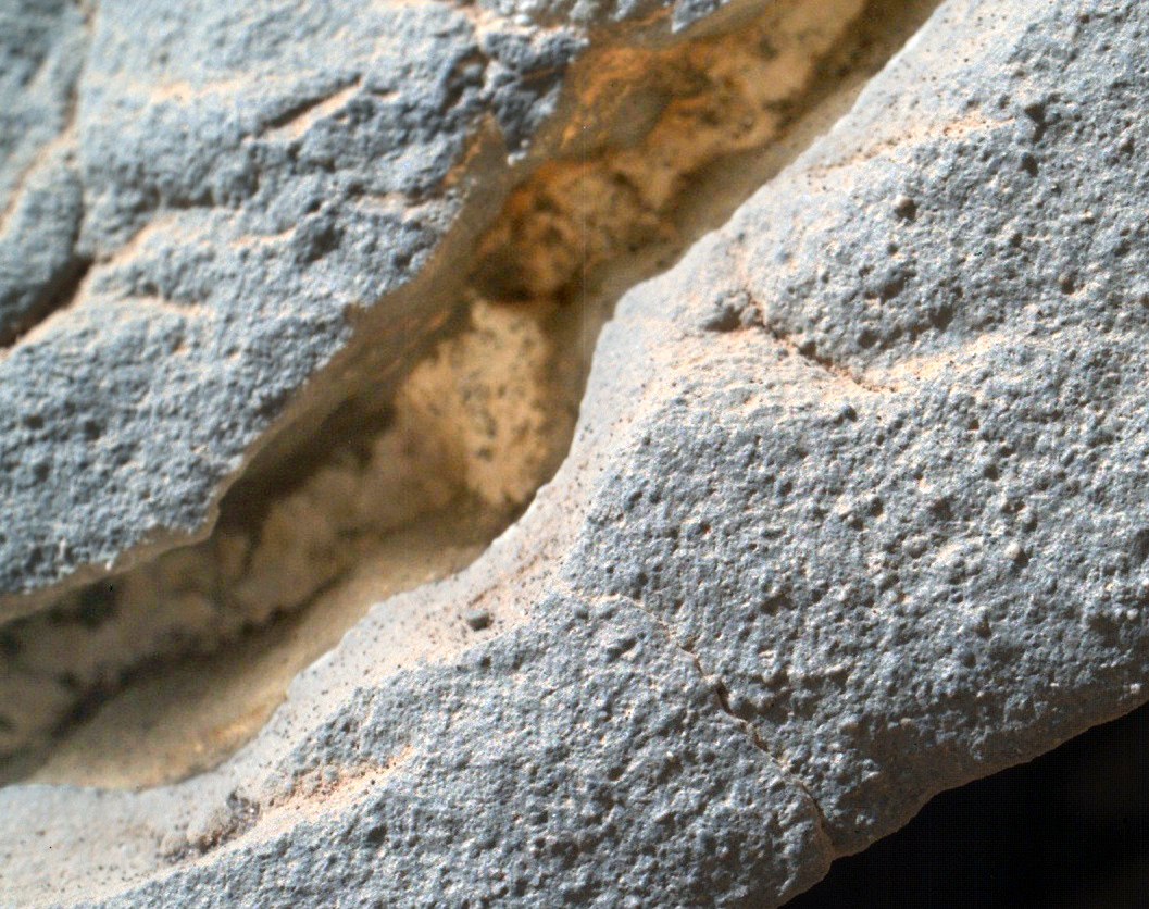
However, the most interesting was found earlier:
This is the most natural petrified mud on Mars. The scale (the wide side of the image is approximately 7-10 cm) allows us to state that nothing but small mineral particles with water could form such incrustations. NASA characterizes this breed as «siltstone» - «yl petrified", although the term "used in geology silts ".
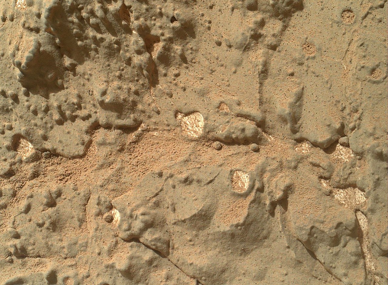
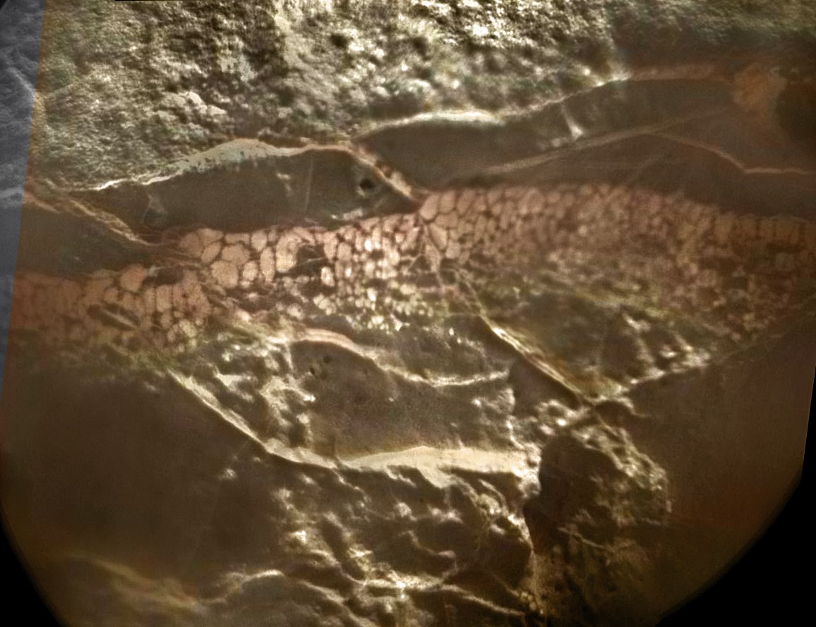
The day before yesterday, when NASA had not yet talked about the results of research, the news “Curiosity found fossilized dirt on Mars” was worthy of the front pages of the yellow newspapers, but even it faded when the next batch of images came:
This is a mosaic of ChemCam photos that reveals a foam- like texture . In the photo of mast cameras, this layer is not so expressive:
Well, it consists, as we now know, of gypsum “knots”, so it is unlikely that NASA will pay more attention to it than it can do it remotely. Although the process of its formation is in question. According to one version, these were gypsum granules that were flooded with the same “dirt”; according to another, it was a porous rock like pumice, in which gypsum accumulated in the same way as in cracks.
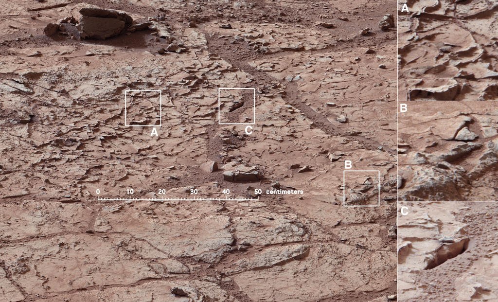
Now, finally, about where will Suriosity drill.
The place called "John Klein" is at the bottom. I thought they would choose sandstone for security reasons, but they preferred a place that was more promising from a scientific point of view.
It looks like a dry puddle, where the dirt cracked on the plates and rose up. They identified three sites that we would like to draw our attention to. Square "A" stands for "veins like ridges" - a type of crack that is characteristic only for this geological layer. “B” indicates the layered nature of the surface, that is, a 5 cm drill can pass through several thin layers, which is more interesting for research. Section “C” is highlighted to draw attention to a crack that is not filled with anything and can be a larger fracture that goes out in depth.
More details can be seen on the panorama of the GigaPan .
Now a small conclusion. Yes, there was water on Mars, there was a lot of it, and these are not sporadic short-term spills caused by meteorites or volcanoes. Streams formed pebbles, accumulated "sludge" and precipitated solutes at the bottom. But there is no novelty in these facts. Opportunity found the same thing, with the possible exception of only pebbles. And gypsum and other minerals formed by water are in his piggy bank. The fact is that all these are traces of water that flowed on Mars during the Hesperides. When powerful volcanic eruptions raged on the planet, and their emissions filled the atmosphere and water with compounds of sulfur and chlorine. But it is still not clear what played the most fatal role for the Martian life possible. Either sulfuric acid and perchlorates, or the eruptions themselves. It is well known that the two recent Great Extinctions on Earth are 250 million and 65 million.Siberia and India . So, if life had been there before, then it did not survive its doomsday. Therefore, “dirt” and gypsum do not promise signs of life. The most delicious is ahead.
( “Pink” photos are calibrated by NASA. They write “processed as it would look on Earth” )
PS Although I understand that nothing of the local fauna can be here, I continue to peer at all new pictures in the hope of seeing that it’s pessimistic realism was wrong. I write about the results here on Habr, on twitter and in contact .