HERE Maps and LiveSight
We told you a lot about exactly how we create our maps, what technologies we use and how responsibly we approach the issue of developing map services.
The other day at the Direct conference, the new cloud-based HERE geolocation technology was introduced, which carries a navigation platform, content and applications suitable for any type of screens and any operating system.

It is logical that we use our own cartographic developments primarily on our own Lumia phones, but we are not limited to them.
We are preparing to launch the free HTML5-based HERE Maps application for iOS, which will soon appear on the App Store. The application will support offline mode, voice guidance along the route and route building taking into account the movement of public transport. In addition, a version of the HERE Maps API for Android and an SDK for OEMs will be introduced over the next few months.

HERE for iOS will allow users to receive directions on navigation when traveling by car, on foot or by public transport.
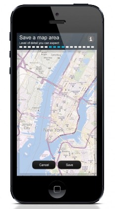
It is possible to download maps of a specific region for subsequent use of maps offline. In this case, a fourfold approximation will be available.

Another interesting feature is voice step-by-step navigation for hiking. Moreover, the application will be available to lay routes taking into account sidewalks, parks and lanes.
The iOS application already has public transport routes for more than 500 cities in the world, this will allow you to move around the city and receive detailed information about transfers. And real information about traffic jams and incidents on the road will allow you to evaluate traffic and spend less time on the road.
In HERE Maps for iOS, you can organize your favorite establishments into categories and quickly share with your friends your impressions of the new cafe through Facebook. HERE.COM also allows you to share your location with one click, sending a simple link via SMS and email.
It is worth mentioning that for Firefox OS in the near future will also be available HERE Maps. Following the ideology of HERE openness, we will continue to work with Mozilla in this direction.
And another very good news: in the coming months, the HERE Android API will become available to developers. Using the applications created in it, users will be able to search for specific buildings, interact with volumetric models and view the laid route in all details. This will allow you to see the whole way clearly and realistically.
Here's an example of what an app built with the HERE Android API might look like.
The video doesn’t show the real application, but the HERE Android API.
Another big announcement is LiveSight, a technology that is based on our 3D world map. The first application using LiveSight technology is Nokia City Lens, an augmented reality service running on Lumia phones.
LiveSight represents a number of mechanisms, namely: 3D-vision, viewing direction, still image and building directory. We will tell a little more about each.
3D vision - buildings are recognized by our data acquisition technology with high accuracy and a sense of depth.
Direction of view - only those places that fall directly into the field of view are displayed.
A freeze frame will allow you to save the real picture in order to examine it in more detail, without pointing the camera at the target.
The building directory provides an opportunity to click on the building to see what is inside it.
With this technology, you can easily find a store in a shopping center or a parking place where you left your own car.
To understand how LiveSight works, watch the video.
The main difference between HERE cards is that they allow users to mark points on the map with their own hands. This data will be accumulated and eventually copied to the main cards, which will allow you to keep the data in a more current state.
In addition, to improve 3D-maps of the world, we plan to acquire the Earthmine company, which offers a comprehensive solution for the collection, processing, management and hosting of 3D-data and terrain. About this at an event held in San Francisco on November 13, 2012, announced the head of Nokia Stephen Elop (Stephen Elop). Earthmine of Berkeley, California, supplies the so-called 3D Street Level Imagery Solutions, that is, solutions for creating 3D images and street level panoramas using our own MARS system. MARS includes special sensors and cameras with which vehicles collecting information are equipped, as well as a number of software solutions for processing incoming data and combining them into a single whole.
Data collection using Earthmine technology will allow you to get the wealth of visual and other data that will bring closer the main goal - automation of cartography. By next year, Earthmine and I plan to expand the number of countries in which 3D information is automatically collected to 31. Earthmine solutions can complement Nokia’s existing methods, which we already talked about in our blog .
The other day at the Direct conference, the new cloud-based HERE geolocation technology was introduced, which carries a navigation platform, content and applications suitable for any type of screens and any operating system.
“Geolocation services should evolve from an application-centric model toward a global user service. Consumers want services that are optimized for a large number of mobile devices and are available anywhere in the world, ”said Tilo Kozlowski, vice president and leading analyst at Gartner.
It is logical that we use our own cartographic developments primarily on our own Lumia phones, but we are not limited to them.
HERE for iOS
We are preparing to launch the free HTML5-based HERE Maps application for iOS, which will soon appear on the App Store. The application will support offline mode, voice guidance along the route and route building taking into account the movement of public transport. In addition, a version of the HERE Maps API for Android and an SDK for OEMs will be introduced over the next few months.
HERE for iOS will allow users to receive directions on navigation when traveling by car, on foot or by public transport.
It is possible to download maps of a specific region for subsequent use of maps offline. In this case, a fourfold approximation will be available.
Another interesting feature is voice step-by-step navigation for hiking. Moreover, the application will be available to lay routes taking into account sidewalks, parks and lanes.
The iOS application already has public transport routes for more than 500 cities in the world, this will allow you to move around the city and receive detailed information about transfers. And real information about traffic jams and incidents on the road will allow you to evaluate traffic and spend less time on the road.
In HERE Maps for iOS, you can organize your favorite establishments into categories and quickly share with your friends your impressions of the new cafe through Facebook. HERE.COM also allows you to share your location with one click, sending a simple link via SMS and email.
HERE Maps for Firefox OS
It is worth mentioning that for Firefox OS in the near future will also be available HERE Maps. Following the ideology of HERE openness, we will continue to work with Mozilla in this direction.
HERE Android API
And another very good news: in the coming months, the HERE Android API will become available to developers. Using the applications created in it, users will be able to search for specific buildings, interact with volumetric models and view the laid route in all details. This will allow you to see the whole way clearly and realistically.
Here's an example of what an app built with the HERE Android API might look like.
The video doesn’t show the real application, but the HERE Android API.
Livesight
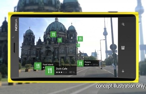
Another big announcement is LiveSight, a technology that is based on our 3D world map. The first application using LiveSight technology is Nokia City Lens, an augmented reality service running on Lumia phones.
LiveSight represents a number of mechanisms, namely: 3D-vision, viewing direction, still image and building directory. We will tell a little more about each.
3D vision - buildings are recognized by our data acquisition technology with high accuracy and a sense of depth.
Direction of view - only those places that fall directly into the field of view are displayed.
A freeze frame will allow you to save the real picture in order to examine it in more detail, without pointing the camera at the target.
The building directory provides an opportunity to click on the building to see what is inside it.
With this technology, you can easily find a store in a shopping center or a parking place where you left your own car.
To understand how LiveSight works, watch the video.
The main difference between HERE cards is that they allow users to mark points on the map with their own hands. This data will be accumulated and eventually copied to the main cards, which will allow you to keep the data in a more current state.
In addition, to improve 3D-maps of the world, we plan to acquire the Earthmine company, which offers a comprehensive solution for the collection, processing, management and hosting of 3D-data and terrain. About this at an event held in San Francisco on November 13, 2012, announced the head of Nokia Stephen Elop (Stephen Elop). Earthmine of Berkeley, California, supplies the so-called 3D Street Level Imagery Solutions, that is, solutions for creating 3D images and street level panoramas using our own MARS system. MARS includes special sensors and cameras with which vehicles collecting information are equipped, as well as a number of software solutions for processing incoming data and combining them into a single whole.
Data collection using Earthmine technology will allow you to get the wealth of visual and other data that will bring closer the main goal - automation of cartography. By next year, Earthmine and I plan to expand the number of countries in which 3D information is automatically collected to 31. Earthmine solutions can complement Nokia’s existing methods, which we already talked about in our blog .