MIT has developed a real-time mapping system for lifeguards
During rescue and search operations, it is vitally important for rescue workers to clearly understand which part of the building they are in, what are the shortest escape routes, which rooms have already been examined, and where their colleagues are working at that moment. This problem is especially acute in case of fire and smoke. MIT created an individual system for automatically building a room map, which allows the lifeguard to always know where it is.
Algorithms for simultaneous navigation and map building , used in robotics, usually work in only two dimensions - the robot smoothly rolls on wheels in a room with a flat floor. For the new sensor, the ability to build complex three-dimensional maps of multi-storey buildings in any conditions is critically important
. The system is based on a laser range finder. It measures the exact distance to the walls of the room and furniture. Autonomous robots are usually equipped with such rangefinders, but when a person carries the sensor, the task becomes much more difficult - you must constantly monitor the scanner's tilt angles relative to the horizon. In addition, for the card to be three-dimensional, you need to know at what height the sensor is. For this, gyroscopes, accelerometers and a barometer are used.
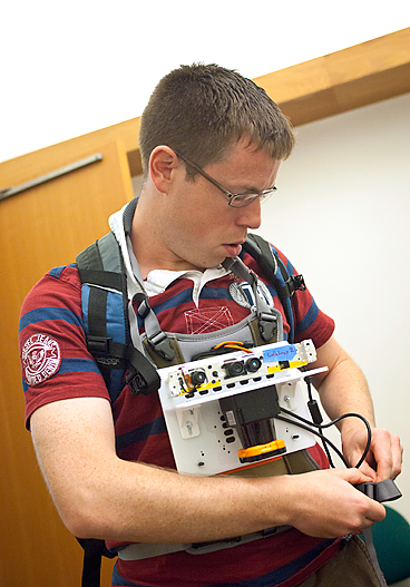 The prototype of the device fits on a plastic panel the size of a tablet and, in addition to the sensors mentioned above, contains a lightweight version of Microsoft Kinect. Every few meters, the camera takes a picture of the environment and correlates it with the data of the rangefinders. The software recognizes and remembers the characteristic details of the image in order to refine the map if the person is in the same place again. When building a map, an error accumulates, which in adverse conditions can reach a meter or more. By “knowing” the places that a person has visited before, the system compensates for this error.
In industrial production, the size of the system can be reduced to almost the size of a conventional cup - all sensors except lidar can be made very compact. In addition, the device will allow you to make voice notes tied to certain places on the map, for example, marking damage and dangerous places. During a rescue operation, all spasters can be equipped with such devices. Information from them will be collected together from the operator, who will be able to effectively coordinate the work of individual groups. Similar devices may find military or police use.
Source - MIT news .
Algorithms for simultaneous navigation and map building , used in robotics, usually work in only two dimensions - the robot smoothly rolls on wheels in a room with a flat floor. For the new sensor, the ability to build complex three-dimensional maps of multi-storey buildings in any conditions is critically important
. The system is based on a laser range finder. It measures the exact distance to the walls of the room and furniture. Autonomous robots are usually equipped with such rangefinders, but when a person carries the sensor, the task becomes much more difficult - you must constantly monitor the scanner's tilt angles relative to the horizon. In addition, for the card to be three-dimensional, you need to know at what height the sensor is. For this, gyroscopes, accelerometers and a barometer are used.
The prototype of the device fits on a plastic panel the size of a tablet and, in addition to the sensors mentioned above, contains a lightweight version of Microsoft Kinect. Every few meters, the camera takes a picture of the environment and correlates it with the data of the rangefinders. The software recognizes and remembers the characteristic details of the image in order to refine the map if the person is in the same place again. When building a map, an error accumulates, which in adverse conditions can reach a meter or more. By “knowing” the places that a person has visited before, the system compensates for this error.In industrial production, the size of the system can be reduced to almost the size of a conventional cup - all sensors except lidar can be made very compact. In addition, the device will allow you to make voice notes tied to certain places on the map, for example, marking damage and dangerous places. During a rescue operation, all spasters can be equipped with such devices. Information from them will be collected together from the operator, who will be able to effectively coordinate the work of individual groups. Similar devices may find military or police use.
Source - MIT news .