2GIS Online knows when the transport will arrive
Probably, each of us at least once in a life had to stand at a stop, wondering when, finally, the transport would arrive (and whether it would arrive at all). We solved this problem in updating 2GIS Online , thanks to a new function that displays how much time is left before the arrival of vehicles at each stop. All you need is just a device with Internet access. True, so far this function only works in Kazan and Nizhny Novgorod.
It’s very simple to find out how long the transport will arrive: you need to click on the stop icon and all the routes passing through it will be shown in the card that appears . For each of these routes, the three nearest arrival times will be shown.
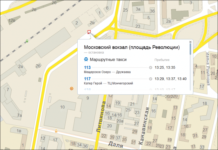
Cards that appear when you click on a bus stop have also changed - now all routes are grouped by type of transport.
Perhaps someone will be interested in where we get this information. We receive data on the time of arrival based on information about the real location of public transport provided to us by partners, whom, by the way, we are actively looking for.
We did not forget about the rest of our products, namely 2GIS for PC and the mobile version: there, too, we should expect the appearance of this functionality, but a little later.
You can find out when transport will nevertheless arrive in Nizhny Novgorod and Kazan right now, and other cities will join in time, as the partnership base grows.
PS If you want to become a partner of 2GIS in launching this feature in your city, write to us at content@2gis.ru .
It’s very simple to find out how long the transport will arrive: you need to click on the stop icon and all the routes passing through it will be shown in the card that appears . For each of these routes, the three nearest arrival times will be shown.
Cards that appear when you click on a bus stop have also changed - now all routes are grouped by type of transport.
Perhaps someone will be interested in where we get this information. We receive data on the time of arrival based on information about the real location of public transport provided to us by partners, whom, by the way, we are actively looking for.
We did not forget about the rest of our products, namely 2GIS for PC and the mobile version: there, too, we should expect the appearance of this functionality, but a little later.
You can find out when transport will nevertheless arrive in Nizhny Novgorod and Kazan right now, and other cities will join in time, as the partnership base grows.
PS If you want to become a partner of 2GIS in launching this feature in your city, write to us at content@2gis.ru .