Experimenting with the new features of Google Earth 5
Officially announced by GE 5.0.
Information about updates on the official website. Here was already the first information about Google Earth 5.0. I have been studying GE since 2005, I would like to share my impressions and professional experience.
The most important of the new features GE has already experimented with:
Added both visual effects (animation of the water surface and glare, underwater tours), as well as depth data (bathymetry). Now you can build isobaths based on these data. An example of combined isobaths and seismic activity data:

Examples of constructing bathymetry in KML format (open in GE 5):
Example 1
Example 2
A full-fledged Mars service has been added, including not only the visual part, but also data on the elevations of the surface. Since the compression ratio of Mars is slightly different from the Earth, some of the marks are negative.
Now we can also build contours and profiles for the surface of Mars and get an excellent tool for comparative geology.


Examples of constructing and analyzing a surface in the KML format:
Koroleva Crater
Analysis of linear elements
Intermittent violations
Newton Crater
Martian Olympus (Olimpius Mons - 20 km altitude!)
I collected all the pictures in a small gallery .
A new feature is the creation of multimedia presentations using Google Earth.
By clicking on the button with the image of the video camera, we can start recording a new video track, which in the future we save as a KMZ file. This file can be run as a presentation.
A special tag system adjusts the position and speed of the camera. An audio recording of the travel story, which can be synchronized, is also saved. The whole process is implemented as a sequence of tags that extend the KML standard with multimedia capabilities.
An example of a KMZ presentation file.
New tags - gx: Playlist, gx: FlyTo, gx: flyToMode, gx: Wait and a number of gx: tags are designed to control the animation.
Example KML text for animation:
Added KML header elements:
Opengis - a link to the OGC-KML standard namespace;
Atom - support for copyright tags;
GX - multimedia support (starting with GE 5), and not only. This line is required if the gx: prefix is used in KML.
Expanded options for the location of the object relative to the surface. To the previously used relativeToGround (relative to the earth's surface), clampToGround - on the earth's surface, their analogues for the ocean floor relativeToSeaFloor , clampToSeaFloor are added . At the same time, for the new relativeToSeaFloor , clampToSeaFloor tags , the gx prefix is required :
In my opinion, it’s illogical, it resembles a temporary measure when separating the OGC-KML standard and the extended GE-KML dialect. What to do, we will adapt.
The options for Camera and LookAt objects are extended with the gx: TimeStamp and gx: TimeStamp time tags . Now we can include abstract views in the timeline:
Extended HTML used in cylinders. First of all, this is the ability to use frame. Now we can embed full pages or entire sites in the description for tags. Previously, this feature was only for flash. KML example with embedded page:
An example of implementing a corporate map:
Open on Google Earth and on a regular page on the site.
We can now also implement documents, presentations, forms.
With the development of GE and the creation of new examples, I plan to post new information.
Information about updates on the official website. Here was already the first information about Google Earth 5.0. I have been studying GE since 2005, I would like to share my impressions and professional experience.
The most important of the new features GE has already experimented with:
- Underwater space
- Martian Chronicles
- Multimedia add-ons (recording tours - pseudo video and audio)
- New Tags in KML
- Extended cylinder html support
Underwater space
Added both visual effects (animation of the water surface and glare, underwater tours), as well as depth data (bathymetry). Now you can build isobaths based on these data. An example of combined isobaths and seismic activity data:
Examples of constructing bathymetry in KML format (open in GE 5):
Example 1
Example 2
Martian Chronicles
A full-fledged Mars service has been added, including not only the visual part, but also data on the elevations of the surface. Since the compression ratio of Mars is slightly different from the Earth, some of the marks are negative.
Now we can also build contours and profiles for the surface of Mars and get an excellent tool for comparative geology.
Examples of constructing and analyzing a surface in the KML format:
Koroleva Crater
Analysis of linear elements
Intermittent violations
Newton Crater
Martian Olympus (Olimpius Mons - 20 km altitude!)
I collected all the pictures in a small gallery .
Multimedia add-ons (recording tours - pseudo video and audio)
A new feature is the creation of multimedia presentations using Google Earth.
By clicking on the button with the image of the video camera, we can start recording a new video track, which in the future we save as a KMZ file. This file can be run as a presentation.
A special tag system adjusts the position and speed of the camera. An audio recording of the travel story, which can be synchronized, is also saved. The whole process is implemented as a sequence of tags that extend the KML standard with multimedia capabilities.
An example of a KMZ presentation file.
New tags - gx: Playlist, gx: FlyTo, gx: flyToMode, gx: Wait and a number of gx: tags are designed to control the animation.
Example KML text for animation:
Test for tour smooth 56.27021426662929 57.95485711700176 40791.74308999955 -1.843426783131765 0 0 absolute 2.534653147257814 1.440764957556894 smooth 56.27021426662929 57.95485711700177 13082.28500104016 -1.843426783131777 0 0 absolute 0.4396044748709755 smooth 56.27021426662929 57.95485711700177 5754.758423761353 -1.843426783131777 0 -3.180554681463517e-015 absolute 1.270543323244056 New Tags in KML
Added KML header elements:
Opengis - a link to the OGC-KML standard namespace;
Atom - support for copyright tags;
GX - multimedia support (starting with GE 5), and not only. This line is required if the gx: prefix is used in KML.
Expanded options for the location of the object relative to the surface. To the previously used relativeToGround (relative to the earth's surface), clampToGround - on the earth's surface, their analogues for the ocean floor relativeToSeaFloor , clampToSeaFloor are added . At the same time, for the new relativeToSeaFloor , clampToSeaFloor tags , the gx prefix is required :
clampToSeaFloor relativeToSeaFloor In my opinion, it’s illogical, it resembles a temporary measure when separating the OGC-KML standard and the extended GE-KML dialect. What to do, we will adapt.
The options for Camera and LookAt objects are extended with the gx: TimeStamp and gx: TimeStamp time tags . Now we can include abstract views in the timeline:
...
Пример 2008-07-29T05:00:00-08:00 -122.518172 37.778036 221.0 70.0 75.0 Extended cylinder html support
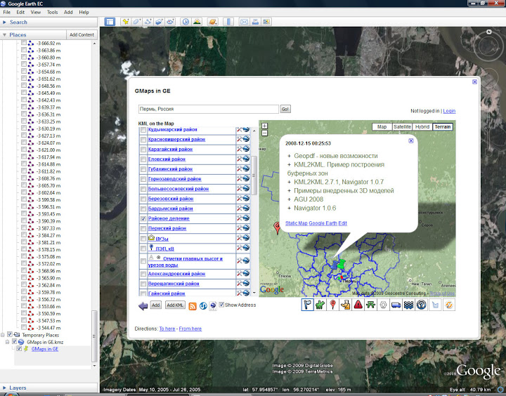
Extended HTML used in cylinders. First of all, this is the ability to use frame. Now we can embed full pages or entire sites in the description for tags. Previously, this feature was only for flash. KML example with embedded page:
GMaps in GE ]]> 56.27177831854188 57.83990541610191 0 144615.4273755389 0 -1.842148610693785 #msn_ylw-pushpin 56.27723011651924,57.95675587999278,0 An example of implementing a corporate map:
Open on Google Earth and on a regular page on the site.
We can now also implement documents, presentations, forms.
With the development of GE and the creation of new examples, I plan to post new information.