Everyscape.com - a promising 3D surfer in the city
- Transfer
Here is a translation of an article by Tim O'Reilly 3D WorldViewer Everyscape Launches . I highly recommend watching the video below. I would like to say from myself that there would be more such services in Russia, i.e. at least one :)
Here you can find the tigger article about this site. I recommend reading it.

Everyscape is a new service that takes photos and three-dimensional files and creates a three-dimensional world on their basis. Today you can “walk” through four cities ( Boston, New York, Miami and Aspen). This technology allows anyone with a suitable camera and GPS to contribute to the development of the project. Most of the materials in the city of Boston were made by company employees, but soon the project will have to be filled mainly by users.
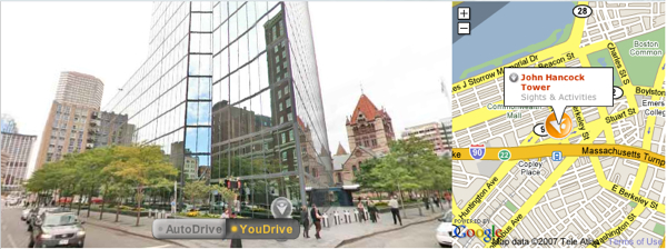
On the map pageFlash displays a three-dimensional view of the street, which is synchronized with the Google map on the right (see screenshot above). The map can be used for quick navigation around the city. In the three-dimensional view of the city, you can move by clicking on the arrows and moving through the picture in a given direction. Most 3D views have the ability to rotate 360 degrees, and up and down too. A large orange mark (like a chess pawn) indicates the presence of useful information about this place. The service has a catalog of hotels, restaurants and other companies. They are sorted into a searchable directory. When an object is found, just click on it to move to the point in the city where it is located. This can be useful to get a complete visual representation of the place you intend to go.

The image on the left in 3D shows Aspen Mountains , and on the right an ordinary map. There are interesting examples on the site, where the developers made views inside the buildings, and as a linear map they display the floor plan. The guys took a map, sets of photos and made a conveniently navigable service. Everyscape.com will be successful when they leave the beaten track and give you the opportunity to walk around small towns and other places that are not economically beneficial to most other geo-services.
In the end, I want to show on the video how approximately this service works.
PS This is my first translation of the article, and I recently at Habré. Therefore, I ask you not to kick hard on the liver.
Here you can find the tigger article about this site. I recommend reading it.

Everyscape is a new service that takes photos and three-dimensional files and creates a three-dimensional world on their basis. Today you can “walk” through four cities ( Boston, New York, Miami and Aspen). This technology allows anyone with a suitable camera and GPS to contribute to the development of the project. Most of the materials in the city of Boston were made by company employees, but soon the project will have to be filled mainly by users.
On the map pageFlash displays a three-dimensional view of the street, which is synchronized with the Google map on the right (see screenshot above). The map can be used for quick navigation around the city. In the three-dimensional view of the city, you can move by clicking on the arrows and moving through the picture in a given direction. Most 3D views have the ability to rotate 360 degrees, and up and down too. A large orange mark (like a chess pawn) indicates the presence of useful information about this place. The service has a catalog of hotels, restaurants and other companies. They are sorted into a searchable directory. When an object is found, just click on it to move to the point in the city where it is located. This can be useful to get a complete visual representation of the place you intend to go.

The image on the left in 3D shows Aspen Mountains , and on the right an ordinary map. There are interesting examples on the site, where the developers made views inside the buildings, and as a linear map they display the floor plan. The guys took a map, sets of photos and made a conveniently navigable service. Everyscape.com will be successful when they leave the beaten track and give you the opportunity to walk around small towns and other places that are not economically beneficial to most other geo-services.
In the end, I want to show on the video how approximately this service works.
PS This is my first translation of the article, and I recently at Habré. Therefore, I ask you not to kick hard on the liver.
