News from the world of OpenStreetMap No. 464 (04/04/2019 - 06/10/2019)
- Transfer
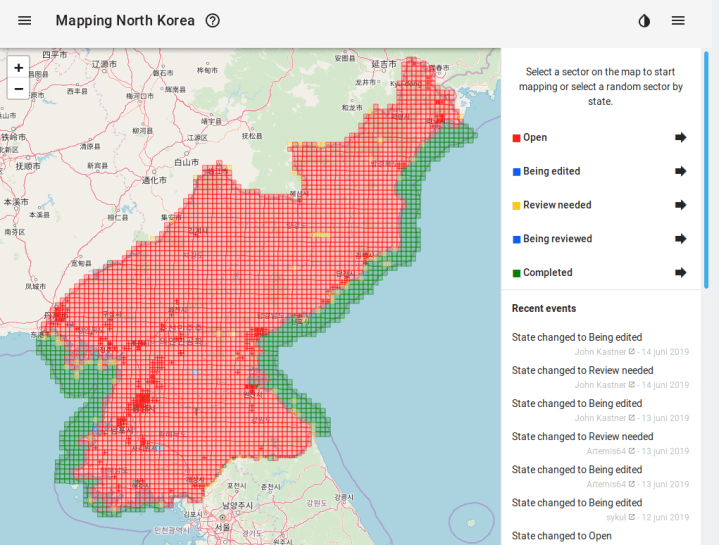
Mapping North Korea - Maarten van den Hoven's new project 1 | Map data OpenStreetMap contributors, ODbL
Mapping
- Jean-Louis Zimmerman tweeted
 some unusual objects that challenge the OSM tagging system.
 - Joseph Eisenberg published on the Tagging mailing list his proposal for the introduction of a new tag
waterway=tidal_channel, which proposes marking natural waterways. He also draws attention to the fact that this issue was already raised in September 2018. - Osmer Simon Legner said ( translated ) on the Talk-at mailing list that he had added new layers of the Austrian Government's Open Data Portal (OGD) to the OSM Editor Layer Index. More detailed information can be found on his page on GitHub.
- [1] Mapping North Korea - a new project by Maarten van den Hoven , which offers to remotely draw this country. For convenience, he divided North Korea into "squares." You can select any in the web interface of the task manager.
- Often the quality and speed of helping people during emergencies depends on the availability of high-precision maps. For many areas, these maps must first be prepared. Therefore, the non-profit organization Doctors Without Borders uses modern technology and the help of thousands of volunteers. On June 25, 2019 from 19:00 to 22:00 in Berlin, the Wikimedia office will host a carton organized by Missing Maps , during which territories at risk will be drawn.
Community
- Nicholas Shavent posted on his Twitter photo from a two-week free geomatics training course held in Brazzaville, Congo. They were intended for the local OSM community, local authorities, researchers and developers. The courses were organized with the assistance of the Congolese communities, the Tongolez Cartographer organization, and also with the support of the Francophonie international organization.
- The question was asked on the OSM-talk mailing list : does anyone want to organize a discussion about the iD online editor at the upcoming SotM conference. However, it was suggested that holding a “tribunal” over iD is not a good idea, but it would be nice to collect ideas on this subject by September 1, and then discuss them.
- Osmer Joseph Eisenberg asked on the OSM-talk mailing list whether the short tag descriptions in WikiOSM should really be stored in the "data fragments" (
data item) for the tag. Prior to this, he found that some tags, likenatural=peninsulaornatural=isthmus, have too short descriptions. Trying to edit them, he did not find a description field. Other users suggested that you look for it in the metadata for the tag. Eisenberg complains that the description of "data fragments" and Wikibase in our WikiOSM is confusing and therefore useless for ordinary editors like him. - Following the discussion ( translation ) on the German forum on how to mark stores that sell goods without packaging (they were previously marked
bulk_purchase), the exact same ( translation ) in French began. These two discussions are in no way related. Now the discussion of this issue has begun in English in a topic entitled “Tag [ging] shops accepting that customers bring their own containers”).
Imports
- HOT created a "Task Manager" to import computer (machine) vision.
OpenStreetMap Foundation
- The protocol of the meeting of the working group according to OSMF data dated May 22, 2019 was published .
Humanitarian OSM
- The geospatialworld website has published an article about the non-profit organization Missing Maps. It tells about the project and its goals.
- At the Intel Folsom office, the non-profit organization Missing Maps held a carton. It was attended by 56 cartographers, two volunteers from the Red Cross and one from Intel to answer questions. More information about this event can be found here .
Cards
- Said Tursever spoke on Twitter about ICT4Society, a Turkish project that uses OSM and Mapillary to help people with disabilities move around the city. Link to the map .
Licenses
- After a long dialogue with Facebook and its Mapbox providers, Nuno Caldeira asked the OSMF advice to ban Facebook from using OSM data in accordance with the provisions of the ODbL license. As a justification for such actions, he refers to Article 9.4 c) of the ODbL license. Recall that this was preceded by a long discussion ( in February and March ) about the explicit indication of the use of OSM, which took place on the Talk main mailing list.
Software
- User K_sakanoshita published ( Twitter , Facebook ) a new version of the online service “Machi-aruki Map maker“ , which can be used to create printed maps during natural disasters and more. New features have appeared: the addition of cafes and restaurants, fire hydrants and tags.
Programming
- Quincy Morgan suggests making an iD from version 3.0 in his ticket on GitHub to become the general editor of the GeoJSON format.
Releases
- In the new version of OsmAnd 2.80 for iOS, images from Mapillary began to be displayed, as it is already implemented on Android. Besides having improved performance, enough bugs have been fixed. Learn more about all the changes you can read in OsmAnd blog.
Do you know ...
- ... that just a few lines of code using the 3D tool “3D OSM Buildings” allow you to make a rotating panoramic view.
Other geo events
- Not so long ago, a glass bridge was opened in East China , which is currently the longest in the world. A new attraction is located in Huashi Adventure Park, which is located near the Great Wall of China. Its length is 518 meters. The length of the previous similar record holder is 488 meters. You can find this object on OSM.
- Margaret Lee on the Mapbox blog talks about the “route from blank map to live map”.
- Malvika Mahesh, a trainee researcher at the Observer Research Foundation , ponders in her article “Line drawing on the Internet: conflicts with borders and politics outside digital maps” about how the concept of borders is interpreted on digital maps. She praises the OpenStreetMap rule - “as it is on Earth "(" OSM Disputed Territory Mapping Rules (PDF), which are not always respected by OSM) and criticizes Google’s current approach. This article has an interesting link - to a map on which all disputed territories of the world are marked.
- June 5th was World Environment Day . In the post of the Giscience news blog of the University of Heidelberg dedicated to this date, there is a link to the global climate protection map, which is based on OSM. Also, the authors of this material urge everyone to contribute to climate protection, namely, to begin to be guided by eco-principles in their life (energy conservation, reuse, etc.)
- How Berlin, from a city convenient for cars, turns into a city for cyclists - can be seen on the FixMyBerlin website . It also shows the current level of cyclist friendliness in the city.
- BMW has published ( translated ) “road safety data” collected by BMW vehicles. This information was posted under the CC-BY-NC-SA license, which excludes commercial use, but despite this, in a press release, BMW mistakenly calls it "free."
Communication of Russian OpenStreetMap participants is in the Telegram chat room and on the forum .
There are also groups on social networks VKontakte , Facebook , but they mainly publish news.
Join OSM!