Missing maps: as a project for decoding the human genome, only for cities
- Transfer
A huge number of settlements, the most vulnerable to disasters and epidemics, remained a blank spot on the world map ... until today. Become a part of an unprecedented plan: map the farthest corners of the world.
The Guardian Cities department will host the meeting card for the Missing Maps project: we will draw a map of the African city. Join: cities@theguardian.com
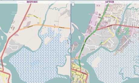
Map of Monrovia (Liberia) before and after. Thanks to the Humanitarian OpenStreetMap Team (HOT), a free electronic map will help the city in the fight against the Ebola virus.
In 2010, an earthquake hit Haiti. Hundreds of thousands of people died. But the worst was ahead. The cholera epidemic escaped out of control. Médecins Sans Frontières, MSF, contacted Ivan Gayton of the Doctors Without Borders organization from a remote village lost in Haitian forests. “Please help,” she asked, “We are overtaken by a terrible disease that we have not yet encountered.”
Ivan sent the MSF group on several trucks to the Baradères settlement to help a nurse. Their maps of the area were very conditional. Entering every village, they thought: “It seems to be the same: the inhabitants here are dying like flies.” But no. Leaving doctors and equipment, they rode on past thousands of dying residents. The road was cut short - they took a boat and sailed along the shore. Finally, a pier appeared, "littered with corpses, like firewood," according to Gayton. That nurse worked here. MSF employees did everything in their power. Over the next few days, more than 600 terminally ill people arrived. Doctors have saved many; at least half would most likely die.
In Haiti, among patients with Doctors Without Borders, less than one percent died from cholera. Among those residents to whom assistance did not reach, mortality was 40 percent. The $ 100 million donated to charities saved countless lives, but thousands of people in Haiti died anyway. Gayton compares the choice of places for medical camps with the sorting of patients in military hospitals. “Someone is seriously injured, but can wait, someone at death, has to choose those who are able between them in order to save as many lives as possible. It’s impossible to help everyone, ”he says. “Entire villages and regions of Haiti were abandoned to die. Calls like that from the nurse came weekly. But he was one of the few that we responded to. I am sure we have lost a huge number of people. "
Visualization of one year of edits on OpenStreetmap.
It was very difficult for us to answer the question: our expedition to Baraderes, was it the best use of the available forces? “Haiti was a gigantic emergency operation, and we, the Doctors Without Borders, ourselves took responsibility for it, but we could not do everything. "I was focused on pinpointing exactly where our help is most in demand: where we can provide the most help for the greatest number of people."
Location, location, location is the cornerstone of epidemiology since John Snow collected the addresses of cholera victims, plotted them on a map of London, tracked the source of cholera in Soho and blocked the infected water intake. However, after a century and a half, cholera and other diseases continue to torment our world. And one of the reasons for our failures is the lack of terrain maps.
Surprisingly, a large number of cities around the world remain unmapped. No one knows for sure how many there are, but more than a million people in developing countries live day by day without accurate maps of their cities. Employees of organizations that help these territories in development buy up photocopies of photocopies of maps, collect names of places from announcements, use satellite images without the names of streets and cities, or are forced to find out the way from local residents each time.
In the West, we take for granted that every street of every city is on Google maps, here, when Doctors without Borders asked the patient where he came from, often they didn’t even have any idea what kind of answer they got. Bobere - what is it? Street, village, district, region, or perhaps a province? “Often, this can be a random set of sounds!” Says Gayton: “If there was one source of cholera in Haiti, we would never know where it is. “We needed a map to compare the messages that came to us and the places described by patients with something on the ground.”

Stage 1 ... volunteers at a kart meeting in the city of Kinshasa (Congo) outline satellite imagery in OpenStreetMap. Photographer: Jorieke (Humanitarian Map Assistance Team, HOT)
Gradually, the realization came that detailed maps would be useful not only in Haiti. Moreover, why wait for the crisis? If humanitarian agencies had such maps for regions threatened by natural disasters, armed conflicts and epidemics, they would be one step ahead in combating their consequences. But where to get such cards?
An ingenious solution to this problem is the Missing Cards project launched this month. The project will combine the efforts of Doctors Without Borders, American and British Red Cross, the OpenStreetMap Humanitarian Map Help Team and other participants to create free maps for each settlement on earth. The project in importance and scope is no less than the project for decoding the human genome.
The method developed by the OpenStreetMap Humanitarian Map Assistance Team is simple and, what is of utmost importance, allows you to participate in the project remotely.
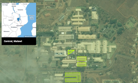
The method is very simple ... the buildings in the city of Malawai, outlined in OpenStreetMap.
Click here to see a live broadcast of the outline of objects.
The first step is to get satellite images. Often snapshots are provided to the community by organizations from which you do not expect this, for example, the US government or Microsoft. Then the pictures become available for sketching in the free OpenStreetMap map editor.
Further on, volunteers from all over the world remotely connect to the process and, in the literal sense, circle the contours of houses, roads, parks and rivers in satellite imagery. Hide the picture, and voila: you have a basic digital map of the city ready.
Then a map, on which there are still no names of streets and places, is printed out and distributed to volunteers directly on the ground. These “ground units” may include students, schoolchildren, members of scout organizations, etc. Each takes a small section of the map and, armed with a pencil, writes down the names of streets and addresses of buildings.
Finally, the completed cards are sent back to the project headquarters in London, where volunteers enter the names in OpenStreetMap. The result is a free, open to all and forever city map.

Stage 2 ... volunteers sign street and house names on a map of Lubumbashi (Congo). Photographer: Jorieke (OpenStreetMap HOT humanitarian map assistance team)
The first serious test of this scheme was Lubumbashi, one of the major cities in Congo, with one and a half million people who have been deprived of such a simple thing as an online map to this day. The missing maps aim to map the remaining poorest urban areas around the world in two years. And due to the fact that the first and last stages can be performed by anyone and anywhere, would be a computer, this scheme is great for crowdsourcing.
Ivan Gayton: “Finally, I can give volunteers the opportunity to help, not only by donating money. Many people want to help Doctors without borders called hands. For example, they propose to knit socks for children in the future. But I answer them, no, don’t - the delivery of these socks and their distribution require much more strength and resources than the benefits that they can give. But with Missing Cards, they can help a real, truly field work. This is a huge help. ”
Absorbing the generalized contribution of ordinary people from all over the world every day, Missing maps can expand coverage to the entire planet. Crowdsourcing also gives the project an advantage over Google maps. The Internet giant is also busy creating its own maps of African cities and territories of developing countries. Listening to reasonable criticism that the company ignores places where there is no way to make money from advertising, Google asks users to supplement their cards. But it is worth remembering that your contribution to Google maps, (regardless of whether they are free now), is wholly owned by Google. If the Internet giant decides to collect money for using cards, nothing will stop him from doing this at any time.
Pete Masters, Project Coordinator Missing Cards: “It’s crucial that the cards are open. Any attempt to restrict the use of these cards will be illegal. This means that local residents will always have access to the map, not only the ability to see the map, but also the ability to edit and develop the map. ”
This idea ignites the imagination of the inhabitants in places that are not on the map, says Gaiton. “The license of the project protects the data, preventing it from being stolen, closed or appropriated. These cards are created by the sincere work of volunteers and belong to everyone. Many volunteers simply cannot believe it. ”
On the map ... Lubumbashi (Congo) got a free, open digital card. Thanks to the project Missing cards. Photographer: Phil Moore / AFP / Getty
In fact, the project has already started: Doctors Without Borders and the Red Cross have already begun recruiting new volunteers ready to join the OpenStreetMap Humanitarian Map Help Team, teaching them how to map settlements where the Ebola virus got out of control. Ultimately, the Missing Cards project will need to assemble the largest team of volunteers.
The benefits of a digital map of all settlements on Earth, of course, not only in the field of epidemiology. There are many options for its application in the field of urbanism, such as traffic planning, pollution control, development planning, etc.
“We're used to thinking of maps as a tool for finding a restaurant nearby or part of a satellite navigation system,” said Harry Wood, member of the board’s humanitarian map help team at OpenStreetMap. “In addition, maps are widely used in urban studies, for example, to decide which of the roads a bus route should go through or where to build a new road in the first place. Think about it, maps are a very basic brick of our knowledge, involved in the development of the urban environment in many ways, quietly and imperceptibly improving our lives. ”
“It’s important that cards help more than just fighting Ebola and cholera,” says Wood. “Sooner or later, the Ebola epidemic will recede, but OpenStreetMap will remain an information resource that quietly helps urban planning and gradually promotes economic growth in these regions.”
As well as the project of decoding the human genome, as a result of which a complete record of all human genes was created, repeatedly used by scientists around the world to study diseases and develop new medicines, city maps are a building block of urban planning, regardless of whether you struggle Are you with cholera or crime. Missing cards are a crucial first step. For most of the developing world, our current maps can be a call: Ahead of the Dragons. We have a long way to go, but at least someone took a sword.
From the translator:
Humanitarian site OpenStreetMap hotosm.org
Tracker with tasks for drawing pictures for HOT projects: tasks.hotosm.org
Missing Maps project pagemissingmaps.org (Unfortunately, with incorrectly configured CName at the moment).
The Guardian Cities department will host the meeting card for the Missing Maps project: we will draw a map of the African city. Join: cities@theguardian.com
Map of Monrovia (Liberia) before and after. Thanks to the Humanitarian OpenStreetMap Team (HOT), a free electronic map will help the city in the fight against the Ebola virus.
In 2010, an earthquake hit Haiti. Hundreds of thousands of people died. But the worst was ahead. The cholera epidemic escaped out of control. Médecins Sans Frontières, MSF, contacted Ivan Gayton of the Doctors Without Borders organization from a remote village lost in Haitian forests. “Please help,” she asked, “We are overtaken by a terrible disease that we have not yet encountered.”
Ivan sent the MSF group on several trucks to the Baradères settlement to help a nurse. Their maps of the area were very conditional. Entering every village, they thought: “It seems to be the same: the inhabitants here are dying like flies.” But no. Leaving doctors and equipment, they rode on past thousands of dying residents. The road was cut short - they took a boat and sailed along the shore. Finally, a pier appeared, "littered with corpses, like firewood," according to Gayton. That nurse worked here. MSF employees did everything in their power. Over the next few days, more than 600 terminally ill people arrived. Doctors have saved many; at least half would most likely die.
In Haiti, among patients with Doctors Without Borders, less than one percent died from cholera. Among those residents to whom assistance did not reach, mortality was 40 percent. The $ 100 million donated to charities saved countless lives, but thousands of people in Haiti died anyway. Gayton compares the choice of places for medical camps with the sorting of patients in military hospitals. “Someone is seriously injured, but can wait, someone at death, has to choose those who are able between them in order to save as many lives as possible. It’s impossible to help everyone, ”he says. “Entire villages and regions of Haiti were abandoned to die. Calls like that from the nurse came weekly. But he was one of the few that we responded to. I am sure we have lost a huge number of people. "
Visualization of one year of edits on OpenStreetmap.
It was very difficult for us to answer the question: our expedition to Baraderes, was it the best use of the available forces? “Haiti was a gigantic emergency operation, and we, the Doctors Without Borders, ourselves took responsibility for it, but we could not do everything. "I was focused on pinpointing exactly where our help is most in demand: where we can provide the most help for the greatest number of people."
Location, location, location is the cornerstone of epidemiology since John Snow collected the addresses of cholera victims, plotted them on a map of London, tracked the source of cholera in Soho and blocked the infected water intake. However, after a century and a half, cholera and other diseases continue to torment our world. And one of the reasons for our failures is the lack of terrain maps.
Surprisingly, a large number of cities around the world remain unmapped. No one knows for sure how many there are, but more than a million people in developing countries live day by day without accurate maps of their cities. Employees of organizations that help these territories in development buy up photocopies of photocopies of maps, collect names of places from announcements, use satellite images without the names of streets and cities, or are forced to find out the way from local residents each time.
In the West, we take for granted that every street of every city is on Google maps, here, when Doctors without Borders asked the patient where he came from, often they didn’t even have any idea what kind of answer they got. Bobere - what is it? Street, village, district, region, or perhaps a province? “Often, this can be a random set of sounds!” Says Gayton: “If there was one source of cholera in Haiti, we would never know where it is. “We needed a map to compare the messages that came to us and the places described by patients with something on the ground.”
Stage 1 ... volunteers at a kart meeting in the city of Kinshasa (Congo) outline satellite imagery in OpenStreetMap. Photographer: Jorieke (Humanitarian Map Assistance Team, HOT)
Gradually, the realization came that detailed maps would be useful not only in Haiti. Moreover, why wait for the crisis? If humanitarian agencies had such maps for regions threatened by natural disasters, armed conflicts and epidemics, they would be one step ahead in combating their consequences. But where to get such cards?
An ingenious solution to this problem is the Missing Cards project launched this month. The project will combine the efforts of Doctors Without Borders, American and British Red Cross, the OpenStreetMap Humanitarian Map Help Team and other participants to create free maps for each settlement on earth. The project in importance and scope is no less than the project for decoding the human genome.
The method developed by the OpenStreetMap Humanitarian Map Assistance Team is simple and, what is of utmost importance, allows you to participate in the project remotely.
The method is very simple ... the buildings in the city of Malawai, outlined in OpenStreetMap.
Click here to see a live broadcast of the outline of objects.
The first step is to get satellite images. Often snapshots are provided to the community by organizations from which you do not expect this, for example, the US government or Microsoft. Then the pictures become available for sketching in the free OpenStreetMap map editor.
Further on, volunteers from all over the world remotely connect to the process and, in the literal sense, circle the contours of houses, roads, parks and rivers in satellite imagery. Hide the picture, and voila: you have a basic digital map of the city ready.
Then a map, on which there are still no names of streets and places, is printed out and distributed to volunteers directly on the ground. These “ground units” may include students, schoolchildren, members of scout organizations, etc. Each takes a small section of the map and, armed with a pencil, writes down the names of streets and addresses of buildings.
Finally, the completed cards are sent back to the project headquarters in London, where volunteers enter the names in OpenStreetMap. The result is a free, open to all and forever city map.
Stage 2 ... volunteers sign street and house names on a map of Lubumbashi (Congo). Photographer: Jorieke (OpenStreetMap HOT humanitarian map assistance team)
The first serious test of this scheme was Lubumbashi, one of the major cities in Congo, with one and a half million people who have been deprived of such a simple thing as an online map to this day. The missing maps aim to map the remaining poorest urban areas around the world in two years. And due to the fact that the first and last stages can be performed by anyone and anywhere, would be a computer, this scheme is great for crowdsourcing.
Ivan Gayton: “Finally, I can give volunteers the opportunity to help, not only by donating money. Many people want to help Doctors without borders called hands. For example, they propose to knit socks for children in the future. But I answer them, no, don’t - the delivery of these socks and their distribution require much more strength and resources than the benefits that they can give. But with Missing Cards, they can help a real, truly field work. This is a huge help. ”
Absorbing the generalized contribution of ordinary people from all over the world every day, Missing maps can expand coverage to the entire planet. Crowdsourcing also gives the project an advantage over Google maps. The Internet giant is also busy creating its own maps of African cities and territories of developing countries. Listening to reasonable criticism that the company ignores places where there is no way to make money from advertising, Google asks users to supplement their cards. But it is worth remembering that your contribution to Google maps, (regardless of whether they are free now), is wholly owned by Google. If the Internet giant decides to collect money for using cards, nothing will stop him from doing this at any time.
Pete Masters, Project Coordinator Missing Cards: “It’s crucial that the cards are open. Any attempt to restrict the use of these cards will be illegal. This means that local residents will always have access to the map, not only the ability to see the map, but also the ability to edit and develop the map. ”
This idea ignites the imagination of the inhabitants in places that are not on the map, says Gaiton. “The license of the project protects the data, preventing it from being stolen, closed or appropriated. These cards are created by the sincere work of volunteers and belong to everyone. Many volunteers simply cannot believe it. ”
On the map ... Lubumbashi (Congo) got a free, open digital card. Thanks to the project Missing cards. Photographer: Phil Moore / AFP / Getty
In fact, the project has already started: Doctors Without Borders and the Red Cross have already begun recruiting new volunteers ready to join the OpenStreetMap Humanitarian Map Help Team, teaching them how to map settlements where the Ebola virus got out of control. Ultimately, the Missing Cards project will need to assemble the largest team of volunteers.
The benefits of a digital map of all settlements on Earth, of course, not only in the field of epidemiology. There are many options for its application in the field of urbanism, such as traffic planning, pollution control, development planning, etc.
“We're used to thinking of maps as a tool for finding a restaurant nearby or part of a satellite navigation system,” said Harry Wood, member of the board’s humanitarian map help team at OpenStreetMap. “In addition, maps are widely used in urban studies, for example, to decide which of the roads a bus route should go through or where to build a new road in the first place. Think about it, maps are a very basic brick of our knowledge, involved in the development of the urban environment in many ways, quietly and imperceptibly improving our lives. ”
“It’s important that cards help more than just fighting Ebola and cholera,” says Wood. “Sooner or later, the Ebola epidemic will recede, but OpenStreetMap will remain an information resource that quietly helps urban planning and gradually promotes economic growth in these regions.”
As well as the project of decoding the human genome, as a result of which a complete record of all human genes was created, repeatedly used by scientists around the world to study diseases and develop new medicines, city maps are a building block of urban planning, regardless of whether you struggle Are you with cholera or crime. Missing cards are a crucial first step. For most of the developing world, our current maps can be a call: Ahead of the Dragons. We have a long way to go, but at least someone took a sword.
From the translator:
Humanitarian site OpenStreetMap hotosm.org
Tracker with tasks for drawing pictures for HOT projects: tasks.hotosm.org
Missing Maps project pagemissingmaps.org (Unfortunately, with incorrectly configured CName at the moment).