I suppose not every day our brother has to paint the Red Holm
 On the third day I watched an excellent demonstration of why OpenStreetMap is better than other maps on the Internet.
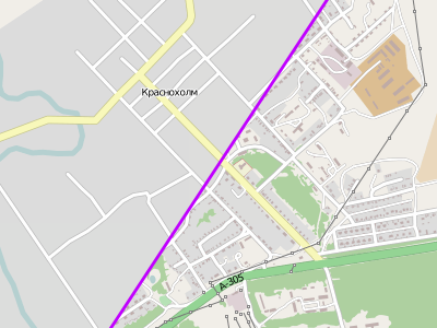
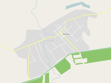
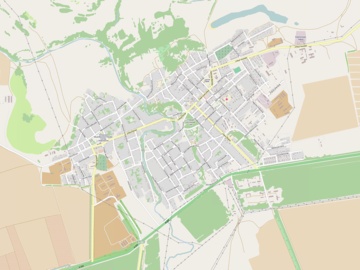
 For two days, the village of Krasnokholm of the Orenburg region and the surroundings were drawn by outside mappers from the state of “several streets” to “everything about which there is relevant information”.
Background
A letter was sent from the RNITS GLONASS to OpenStreetMap asking for help from the Orenburg Ambulance. Ambulance uses programs with OSM and they need address information in the village of Krasnokholm and the two nearest villages. They sent targeted plans for villages and towns, and after some correspondence - even permission from the administration to integrate targeted plans in the OSM.
Quote: “To the Head of OpenStreetMap Moscow”
On the evening of January 22nd information was posted on the OSM forum.
A small run on the Internet showed that
- Yandex maps contain streets and even some POIs, but not at home
- bing cards contain a couple of streets
- Google maps do not even contain streets, only the name of the village
- in Krasnoholme at best, one local OSM mapper - KillGates
- bing satellite images in the village are good, you can see houses and even fences and poles of power lines
- they draw very little in the vicinity - in 2013 there were 1 revision in April and July and 3 revisions in September
It looks like OpenStreetMap in Krasnokholm until January 22 can be estimated by FOSM - there is information from about 2012, but it is pretty good with what is in the OSM dump from the morning of the 22nd.
2 hours after the announcement on the forum, the good man lzhl created a “pie” in mapcraft ...
And it began
In a day, all houses, all streets, and all addresses were painted. But the mappers did not stop there. The “shock wave" of enthusiasm in the vicinity of the village and villages specified the roads, the contours of the forest and rivers, painted sheds, single trees, land use plots, power lines, etc.
On the 23rd evening I could not find what else to draw in the village. He drew only a couple of tracks to the north.
“Stunned, for the first time in my life I wanted to participate in a sofa cartopat, and it turned out that we had already eaten the whole pie :(" literan
"The day before yesterday there was a void, today is a garden city" ZverikFor the second day, the rendering was polished to a shine.


“Tom had a great time all this, doing nothing and having fun, and the fence was covered with lime in three layers! If he hadn’t run out of it, he would have ruined all the boys in the city. ”
Mark Twain,“ The Adventures of Tom Sawyer ”
And where does the ... fence? o_o
В известном эпизоде Том замотивировал соседских мальчишек красить забор извёсткой вместо него и ещё получил за это кучу ништяков. Обязательно прочитайте эту главу книги.
Заголовок этой статьи — перефразированная ключевая фраза Тома.
Заголовок этой статьи — перефразированная ключевая фраза Тома.
The result of the work - a printed map with marks of obscure places will be transferred to the local paramedic,
“And as far as possible she will sign what and how. Of course, it’s not good to strain doctors, but they themselves need it ”(c) ErshKUS
Video clip
Based on the results of the shock rendering, it was decided to make a video.
Unlike last time , to create this video it was required to shovel a significantly smaller amount of information. It turned out that only one dump from the GIS-Lab area (RU-ORE-140122) and ten daily OSM diffs were enough .
The same processing scheme was used:
- Filtering and sorting data with a homemade program
- Homemade render in SVG
- Convert to BMP via ImageMagick
- Build videos in avidemux
Additionally were used
- Maperitive for creating a starting frame (map state at noon on January 22)
- ImageMagick for fade in / out
We considered the option to render all frames in Maperitive or an analogue, but there is no highlighting of fresh changes there, so the appearance of houses and other minor changes would be almost invisible. In addition, it would be necessary to pull out all versions of all relations from the database.
A set of OSM data can be downloaded (relation there is not everything).
Video without music was uploaded as a file (25 MB) under the license of CC-BY-SA 3.0.
Felis Pimeja posted his ani-gifs from episodic mapnik screenshots.
Guess the melody
This time a track has been selected for music, which I have not been able to recognize for 7 years now. Maybe someone from the audience or the YouTube mechanism will tell me. If you know what kind of music this is, please write.
Total
In my opinion, the story of the swift rendering of Redholm perfectly demonstrates the advantages of OpenStreetMap:
- If there is a data source - information can be entered very quickly and at the same time will immediately be available to everyone
- To enter data, sometimes a simple request "draw please"
- OpenStreetMap is already used in the regions, despite the presence of commercial cards
- Discrepancies in the source data can be clarified on the ground and corrected in the database
UPD 2014-03-01 The
world’s mind won, the music is identified, it’s
Lily - The rain will cry quietly (instrumental)
Thanks Erelen for the tip
