Three in color. Alternative from Littlesnake
Three-tailed military topographic map of Western Russia in 1845.
This is its first and correct name.
This ancient topographic map of the European part of the Russian Empire, which today is called simply and unpretentiously - three.
Quite a lot has been written about it in Runet; I will note only a few points.
Technical moments.
In "Notes of a military topographic depot" part 10 of 1847. edited by Major General Tuchkov on page 24 the highest approval was published (dated April 2, 1845) on the compilation of a military topographic map of Russia. In this document, projection parameters and sheet sizes of three are indicated. This part freely lies in Runet in scans of the Munich library - anyone can familiarize themselves with this approval.
The RGVIA archive has a curious document (I call it as a practical form of three, about 1.6 m high) with the text “Network of Meridians and Parallel Circles of the Military Topographic Map of Western Russia of 1845 ... Note: Network of Meridians and Parallel Circles of the Military Topographic map of Western Russia, there are coordinates of the intersection points of the meridians and parallel circles in inches, respectively, the scale adopted for the map. i.e.: 3 versts in 1 English inch. The middle meridian of the map passes through the main Pulkovo Observatory. The average latitude of the card is 52 g. The length of the sheet from East to West is 23 inches, its width from North to South is 16.5 inches, the diagonal is 28.306 inches. Compiled by second lieutenant Yegorov 3rd, checked by Captain Manshikov. "
At the end of the 19th century, a slightly different figure appeared in the literature - the average parallel is 54 degrees. It is this figure that is visible in the academic textbooks of V.V. Vitkovsky - Lieutenant General, Chairman of the Department of Mathematical Geography of the Russian Geographical Society and Professor at the Academy of the General Staff. And also in the writings of Scharngorst K.V., Lieutenant General, professor of geodesy and map editor of the General Staff. It seems that they made a mistake here, one of the great ones described himself, and then everyone (out of deep respect) continued AshiPka.
The projection of the three is the pseudo-conical isometric cartographic projection of Bonnet, the central meridian of Pulkovsky, the central parallel is 52 degrees. The sheet size is 23 x 16.5 inches. The spheroid is taken "... according to the conclusions of Professor Valbek from Abo, who defined (compression) 302.78 and (semi-major axis) 2988830.0024 ...", or as is often found in "Notes of the VTD" - "For the figure of the Earth of Valbek accepted for all the works of the Military Topographic Department ... semi-major axis = 2988853 fathoms, compression = 302.78. "
The publication of map sheets was planned up to 28 columns, but with the improvement of the quality of geodetic works at the beginning of the 20th century and the material base, the creation of new sheets was stopped, because a new standard of one-verst maps (Western Border Space) came to life. The number of ready-made sheets for this time can be calculated on Volarovich’s letterhead 1909, indicating which sheets did not have time to do. After the total devastation, the young Soviet state needed maps, and the creation of three (further to the east) continued. In the book of V.V. Kavraisky “Mathematical Cartography” 1934 the number of sheets of three and more than 640 is indicated. In this case, one can note sheets of Mende provinces, the accuracy of which is lower initially, as well as exotic places of the three - Vyatka province, Votskaya region (Udmurtia), Nizhny Novgorod. In the mid-193s, three is considered as an overview map, and Gauss-Krueger is rapidly replacing it. On the site “Feat of the People” there are several scans of three with marks of warfare during the Great Patriotic War of 1941-1945.
Schubert
F.F. Schubert is not the father of three. The term "Three Schubert" is the universal fallacy of our time. The well-known ten-page layout - yes - is associated with F.F. Schubert, but three (for that matter) should be called more correctly by the name of Major General P.A. Tuchkov. For more details, read V.V.Glushkov's “History of Military Cartography in Russia,” p. 115, “Notes of the VTD” of part 9.10. F.F.Schubert undoubtedly did a lot in geodesy and cartography of Russia, but nowhere in the history of cartography of Russia has anyone ever called the three-verst map “the three Schubert”.
Snap three.
On the Monetonos website, a group of comrades (including myself) from January 2011 to January 2012. We disassembled this map for its correct binding in a rectangular coordinate system, and today I have no doubt about the correctness of the chosen method. All the necessary data for the correct binding here in the article I have indicated. All that was left was to create a simple plate in Ehel to calculate the rectangular coordinates of the angles of three, and calculate the parameters of Molodensky to transform the three into other spheroids.
Accuracy of three.
I understand this term as the accuracy of drawing objects on a map. For the General Staff (noted in any textbook of topography) 0.2 mm of scale for all objects, and 0.1 mm for signs of triangulation and landmarks. That is, 0.2 mm for 100k = 20 m. In this case, the General Staff maps are created on the basis of aerial photographs.
Three has a metric scale of 1 cm: 126,000 meters, which is close to the general staff of 100k. The sheet area of three is 23 x 16.5 x 3 x 3 = 3415.5 sq. Verst. From the book of I. Strelbitsky “Calculation of the surface of the Russian Empire in its total composition ...” 1889 we take, for example, the area of the Tula province - 27,204.4 sq. Versts. That is - in the three Tula province fits (purely theoretically) on 27204.4: 3415.5 = 7.96 sheets. The Blaramberg catalog of 1860 shows the number of read points for the Tula province - 403 points. That is, about 50 points per sheet is a very average result. Count, do not be lazy, how many villages, crossroads, river bends, bridges and so on. other other objects SPECIFIED on one sheet of three in the Tula province? I think 200-250. Compare 200-250 objects, and 50 of them have read coordinates. There is something to think about, right? Considering that the three-wheeler was created on the basis of mensulming surveys - a tablet, a field, a forest ... Add the conscience and qualifications of the team that conducted the survey, and the work of the engraver (with a stichel on a copper board, with what accuracy can you draw a curved line?)
I estimate the average accuracy of drawing objects on three - 1/16 - 1/32 inches of the scale, that is, about 50-100 meters. The thickness of the inner frame of the three is approximately equal to 1/16 of an inch. Railways on three were laid, as a rule - schematically, read - from the ceiling.
Binding accuracy.
Krivoruky sellers of bindings came up with this term in order to breed the eared user for money. "The accuracy of the attached three 20 meters" - spit in the face, it does not happen. A sheet of three that is correctly transformed from Valbek to WGS can be checked simply - connect the upper corners of the three with each other in a graphical editor. There should be a “hump” in the center of the leaf, and the farther from the central meridian (passes between 8 and 9 pillars) - the hump is steeper.
The meaning of the term “snap accuracy” - as I understand it - is one pixel. For both you and I are trying with such accuracy to put an end to specialized software by tying a card. That is, the accuracy of binding is the same for all of us, one pixel.
Sheet alignment.
Three is a raster, not a vector. Over the course of its centennial history, a paper card has suffered a lot. Regardless of storage conditions - paper has the ability to dry out, change its size and geometry. Look at the Dokusphere - what sometimes there are curved sheets, with different sizes of sides. Add misunderstandings when scanning and more. Therefore, the three in the binding process must be aligned, that is, brought to their normal appearance - a 23 x 16.5 inch rectangle. This is easily done in the Global Mapper program; a little perseverance is required.
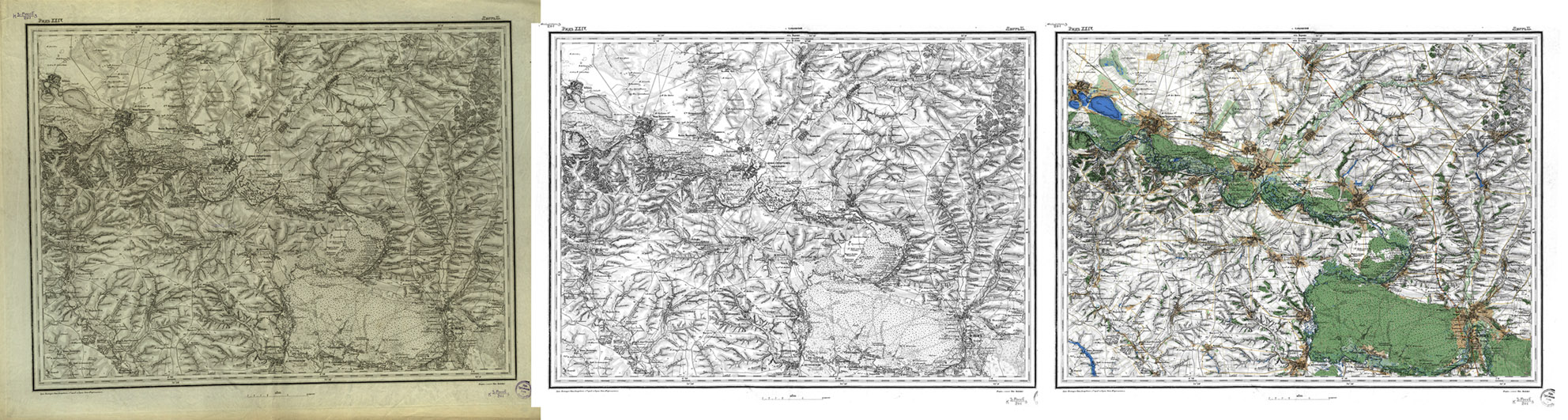
How is colored (dyed) three-dimensional paint made?
In any available way, take the data of the card service - I took Yandex for Russia, Visicom for Ukraine, the 14th level. I transform the kartservice tablets into the Bonn projection on Valbeck, transparently glue them together with the three, cut them off - that's it.
You can take three in color -
- cumulatively on Rutraker - enter the word “Littlesnake” on the main page in the search, and you will be taken to the tracker page with a map,
- by the piece on the site EtoMesto www.etomesto.ru/trehverstka-v-cvete
You can read me on the blog mapofilia-ru.blogspot.ru

This is its first and correct name.
This ancient topographic map of the European part of the Russian Empire, which today is called simply and unpretentiously - three.
Quite a lot has been written about it in Runet; I will note only a few points.
Technical moments.
In "Notes of a military topographic depot" part 10 of 1847. edited by Major General Tuchkov on page 24 the highest approval was published (dated April 2, 1845) on the compilation of a military topographic map of Russia. In this document, projection parameters and sheet sizes of three are indicated. This part freely lies in Runet in scans of the Munich library - anyone can familiarize themselves with this approval.
The RGVIA archive has a curious document (I call it as a practical form of three, about 1.6 m high) with the text “Network of Meridians and Parallel Circles of the Military Topographic Map of Western Russia of 1845 ... Note: Network of Meridians and Parallel Circles of the Military Topographic map of Western Russia, there are coordinates of the intersection points of the meridians and parallel circles in inches, respectively, the scale adopted for the map. i.e.: 3 versts in 1 English inch. The middle meridian of the map passes through the main Pulkovo Observatory. The average latitude of the card is 52 g. The length of the sheet from East to West is 23 inches, its width from North to South is 16.5 inches, the diagonal is 28.306 inches. Compiled by second lieutenant Yegorov 3rd, checked by Captain Manshikov. "
At the end of the 19th century, a slightly different figure appeared in the literature - the average parallel is 54 degrees. It is this figure that is visible in the academic textbooks of V.V. Vitkovsky - Lieutenant General, Chairman of the Department of Mathematical Geography of the Russian Geographical Society and Professor at the Academy of the General Staff. And also in the writings of Scharngorst K.V., Lieutenant General, professor of geodesy and map editor of the General Staff. It seems that they made a mistake here, one of the great ones described himself, and then everyone (out of deep respect) continued AshiPka.
The projection of the three is the pseudo-conical isometric cartographic projection of Bonnet, the central meridian of Pulkovsky, the central parallel is 52 degrees. The sheet size is 23 x 16.5 inches. The spheroid is taken "... according to the conclusions of Professor Valbek from Abo, who defined (compression) 302.78 and (semi-major axis) 2988830.0024 ...", or as is often found in "Notes of the VTD" - "For the figure of the Earth of Valbek accepted for all the works of the Military Topographic Department ... semi-major axis = 2988853 fathoms, compression = 302.78. "
The publication of map sheets was planned up to 28 columns, but with the improvement of the quality of geodetic works at the beginning of the 20th century and the material base, the creation of new sheets was stopped, because a new standard of one-verst maps (Western Border Space) came to life. The number of ready-made sheets for this time can be calculated on Volarovich’s letterhead 1909, indicating which sheets did not have time to do. After the total devastation, the young Soviet state needed maps, and the creation of three (further to the east) continued. In the book of V.V. Kavraisky “Mathematical Cartography” 1934 the number of sheets of three and more than 640 is indicated. In this case, one can note sheets of Mende provinces, the accuracy of which is lower initially, as well as exotic places of the three - Vyatka province, Votskaya region (Udmurtia), Nizhny Novgorod. In the mid-193s, three is considered as an overview map, and Gauss-Krueger is rapidly replacing it. On the site “Feat of the People” there are several scans of three with marks of warfare during the Great Patriotic War of 1941-1945.
Schubert
F.F. Schubert is not the father of three. The term "Three Schubert" is the universal fallacy of our time. The well-known ten-page layout - yes - is associated with F.F. Schubert, but three (for that matter) should be called more correctly by the name of Major General P.A. Tuchkov. For more details, read V.V.Glushkov's “History of Military Cartography in Russia,” p. 115, “Notes of the VTD” of part 9.10. F.F.Schubert undoubtedly did a lot in geodesy and cartography of Russia, but nowhere in the history of cartography of Russia has anyone ever called the three-verst map “the three Schubert”.
Snap three.
On the Monetonos website, a group of comrades (including myself) from January 2011 to January 2012. We disassembled this map for its correct binding in a rectangular coordinate system, and today I have no doubt about the correctness of the chosen method. All the necessary data for the correct binding here in the article I have indicated. All that was left was to create a simple plate in Ehel to calculate the rectangular coordinates of the angles of three, and calculate the parameters of Molodensky to transform the three into other spheroids.
Accuracy of three.
I understand this term as the accuracy of drawing objects on a map. For the General Staff (noted in any textbook of topography) 0.2 mm of scale for all objects, and 0.1 mm for signs of triangulation and landmarks. That is, 0.2 mm for 100k = 20 m. In this case, the General Staff maps are created on the basis of aerial photographs.
Three has a metric scale of 1 cm: 126,000 meters, which is close to the general staff of 100k. The sheet area of three is 23 x 16.5 x 3 x 3 = 3415.5 sq. Verst. From the book of I. Strelbitsky “Calculation of the surface of the Russian Empire in its total composition ...” 1889 we take, for example, the area of the Tula province - 27,204.4 sq. Versts. That is - in the three Tula province fits (purely theoretically) on 27204.4: 3415.5 = 7.96 sheets. The Blaramberg catalog of 1860 shows the number of read points for the Tula province - 403 points. That is, about 50 points per sheet is a very average result. Count, do not be lazy, how many villages, crossroads, river bends, bridges and so on. other other objects SPECIFIED on one sheet of three in the Tula province? I think 200-250. Compare 200-250 objects, and 50 of them have read coordinates. There is something to think about, right? Considering that the three-wheeler was created on the basis of mensulming surveys - a tablet, a field, a forest ... Add the conscience and qualifications of the team that conducted the survey, and the work of the engraver (with a stichel on a copper board, with what accuracy can you draw a curved line?)
I estimate the average accuracy of drawing objects on three - 1/16 - 1/32 inches of the scale, that is, about 50-100 meters. The thickness of the inner frame of the three is approximately equal to 1/16 of an inch. Railways on three were laid, as a rule - schematically, read - from the ceiling.
Binding accuracy.
Krivoruky sellers of bindings came up with this term in order to breed the eared user for money. "The accuracy of the attached three 20 meters" - spit in the face, it does not happen. A sheet of three that is correctly transformed from Valbek to WGS can be checked simply - connect the upper corners of the three with each other in a graphical editor. There should be a “hump” in the center of the leaf, and the farther from the central meridian (passes between 8 and 9 pillars) - the hump is steeper.
The meaning of the term “snap accuracy” - as I understand it - is one pixel. For both you and I are trying with such accuracy to put an end to specialized software by tying a card. That is, the accuracy of binding is the same for all of us, one pixel.
Sheet alignment.
Three is a raster, not a vector. Over the course of its centennial history, a paper card has suffered a lot. Regardless of storage conditions - paper has the ability to dry out, change its size and geometry. Look at the Dokusphere - what sometimes there are curved sheets, with different sizes of sides. Add misunderstandings when scanning and more. Therefore, the three in the binding process must be aligned, that is, brought to their normal appearance - a 23 x 16.5 inch rectangle. This is easily done in the Global Mapper program; a little perseverance is required.
How is colored (dyed) three-dimensional paint made?
In any available way, take the data of the card service - I took Yandex for Russia, Visicom for Ukraine, the 14th level. I transform the kartservice tablets into the Bonn projection on Valbeck, transparently glue them together with the three, cut them off - that's it.
You can take three in color -
- cumulatively on Rutraker - enter the word “Littlesnake” on the main page in the search, and you will be taken to the tracker page with a map,
- by the piece on the site EtoMesto www.etomesto.ru/trehverstka-v-cvete
You can read me on the blog mapofilia-ru.blogspot.ru