In the city of Lutsk (Ukraine), public transport was equipped with GPS devices
And not only equipped, but also made a web page on which users can see where each of the 262 buses is located, which operate on 32 routes of the city.
Lutsk was ahead of not only Kiev and Lviv in this matter, but also Vinnitsa, where they have long been talking about the introduction of such a system. This is the first (of the known to us) Ukrainian regional centers that introduced such technologies to almost all public transport.
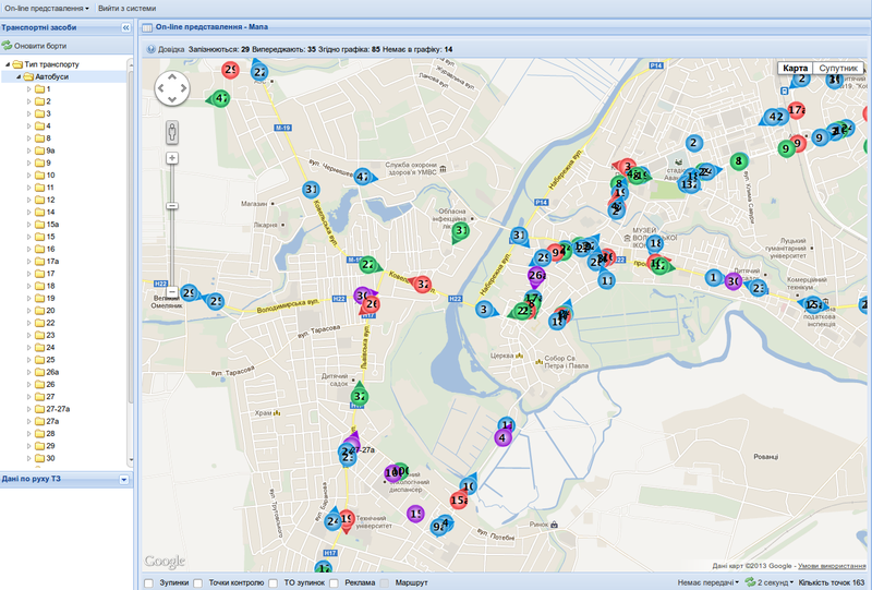
The Transport and Communications Department of the Lutsk City Council, which is involved in the project, reported that the buses equipped GPS even on March 19. An interactive map web page is here: www.mak.lutsk.ua/guest
With such data, now it is possible not only to plan personal trips, but also based on the accumulated data in the future, add up “accessibility maps” of the city (how long can you get to each point) and optimize traffic flows: data from minibuses allow you to determine, for example, whether it’s slowing down or accelerating movement at a certain time in a certain place.
We really hope that Kiev and other cities will be able to make such a service at home in the near future. In the meantime, we sincerely congratulate the city residents and their city authorities on the new useful
UPD service : inlanger user kindly shared links to the Android application for this resource
Paid version and free version
UPD1: readers of this article collected links to similar web services in other cities:
Kazan: www.doroga.tv/kazan/transport openkazan
Murmansk: troll51.ru kinitko
Dnepropetrovsk: transit.in.ua sergebezborodov
Novosibirsk: habrahabr.ru/post / 94557 KAdot
Ekaterinburg: online.ettu.ru/map/trams ASP
St. Petersburg: transport.orgp.spb.ru alexxxst
Ryazan: www.bus62.ru Sudak
Astrakhan: www.busapt.ru geakstr
Arkhangelsk: www.appp29.ru Vagrant
Barnaul: traffic22.ru terrance
Omsk: bus.admomsk.ru iamAnton
Astana: infobus.kz NoorBall
Irkutsk: irkbus.ru Palehin
Yaroslavl: www.ot76.ru ltwood
Original article in Ukrainian
Lutsk was ahead of not only Kiev and Lviv in this matter, but also Vinnitsa, where they have long been talking about the introduction of such a system. This is the first (of the known to us) Ukrainian regional centers that introduced such technologies to almost all public transport.
The Transport and Communications Department of the Lutsk City Council, which is involved in the project, reported that the buses equipped GPS even on March 19. An interactive map web page is here: www.mak.lutsk.ua/guest
With such data, now it is possible not only to plan personal trips, but also based on the accumulated data in the future, add up “accessibility maps” of the city (how long can you get to each point) and optimize traffic flows: data from minibuses allow you to determine, for example, whether it’s slowing down or accelerating movement at a certain time in a certain place.
We really hope that Kiev and other cities will be able to make such a service at home in the near future. In the meantime, we sincerely congratulate the city residents and their city authorities on the new useful
UPD service : inlanger user kindly shared links to the Android application for this resource
Paid version and free version
UPD1: readers of this article collected links to similar web services in other cities:
Kazan: www.doroga.tv/kazan/transport openkazan
Murmansk: troll51.ru kinitko
Dnepropetrovsk: transit.in.ua sergebezborodov
Novosibirsk: habrahabr.ru/post / 94557 KAdot
Ekaterinburg: online.ettu.ru/map/trams ASP
St. Petersburg: transport.orgp.spb.ru alexxxst
Ryazan: www.bus62.ru Sudak
Astrakhan: www.busapt.ru geakstr
Arkhangelsk: www.appp29.ru Vagrant
Barnaul: traffic22.ru terrance
Omsk: bus.admomsk.ru iamAnton
Astana: infobus.kz NoorBall
Irkutsk: irkbus.ru Palehin
Yaroslavl: www.ot76.ru ltwood
Original article in Ukrainian