USPACE - Single Space for Manned and Unmanned Aircraft
In the world of modern civil aviation, USPACE is on the agenda. This is the digital airspace of the future, intended for the implementation of unmanned aircraft on general, equal, conditions in a single, non-segregated sky. To ensure the safety of joint flights, it is necessary to observe a number of important conditions, and the most important of them is high-quality space monitoring 24/7.
The fundamental technological basis for the implementation of routine unmanned aerial flights (what is commonly called the " integration of unmanned aerial systems ") is 4D information about the location of all aircraft:
Joint flights of unmanned and manned aircraft also imply technological compatibility of airborne equipment to ensure mutual radio visibility and coordination of maneuvers.
Most fully and reliably, these data can be obtained in an independent cooperative surveillance system, which involves both equipping the airborne transponders with the АЗН-В 1090ES system and / or S-mode transponders, as well as the presence of a ground-based surveillance infrastructure capable of providing information to both pilots of remotely piloted aircraft and pilots of manned aircraft, and air traffic control.
Based on the observation information, services of other services (identification, monitoring, control) that are not directly involved in flights can also be built:
AZN-V / MPSN ground-based cooperative surveillance equipment provides surveillance for all air traffic participants equipped with appropriate airborne equipment. The first Russian multi-position observation system Almanac is considered as a base for creating continuous seamless observation fields. It allows you to measure the location of air and ground objects with an accuracy of several meters, as well as get on-board navigation information and identification information.
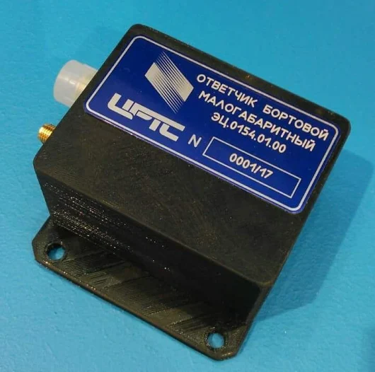
The compact transponders of the AZN-B 1090ES Hummingbird series, which allow the board to "become radio-visible" in the Almanac system, are designed for installation on aircraft of any size. The output power of the transponders is selected in such a way as to ensure the visibility of the aircraft from the side of ground stations (taking into account small flight altitudes and, therefore, inclined ranges) on the one hand, and not to overload the ether, on the other.

Reliable location information with a high update rate, information about the capabilities of potentially conflicting aircraft is necessary for the DAA system (Detect & Avoid), which will replace the visual organs of the remote pilot and the ability to visually assess the environment from the cockpit. The DAA system should provide the pilot of a remotely piloted aircraft with information about surrounding objects, generate warnings about dangerous proximity and recommendations for evasion, as well as recommendations and warnings about potential collisions.
The fundamental technological basis for the implementation of routine unmanned aerial flights (what is commonly called the " integration of unmanned aerial systems ") is 4D information about the location of all aircraft:
- 3D coordinates
- prediction of location in time (course, speed, maneuver parameters, waypoints, etc.)
- identification (including the type and capabilities of aircraft in speed and maneuvering).
Joint flights of unmanned and manned aircraft also imply technological compatibility of airborne equipment to ensure mutual radio visibility and coordination of maneuvers.
Most fully and reliably, these data can be obtained in an independent cooperative surveillance system, which involves both equipping the airborne transponders with the АЗН-В 1090ES system and / or S-mode transponders, as well as the presence of a ground-based surveillance infrastructure capable of providing information to both pilots of remotely piloted aircraft and pilots of manned aircraft, and air traffic control.
Based on the observation information, services of other services (identification, monitoring, control) that are not directly involved in flights can also be built:
- supervisory authorities
- power departments
- search and rescue services
- technical support services
- insurers, etc.
AZN-V / MPSN ground-based cooperative surveillance equipment provides surveillance for all air traffic participants equipped with appropriate airborne equipment. The first Russian multi-position observation system Almanac is considered as a base for creating continuous seamless observation fields. It allows you to measure the location of air and ground objects with an accuracy of several meters, as well as get on-board navigation information and identification information.
The compact transponders of the AZN-B 1090ES Hummingbird series, which allow the board to "become radio-visible" in the Almanac system, are designed for installation on aircraft of any size. The output power of the transponders is selected in such a way as to ensure the visibility of the aircraft from the side of ground stations (taking into account small flight altitudes and, therefore, inclined ranges) on the one hand, and not to overload the ether, on the other.

Reliable location information with a high update rate, information about the capabilities of potentially conflicting aircraft is necessary for the DAA system (Detect & Avoid), which will replace the visual organs of the remote pilot and the ability to visually assess the environment from the cockpit. The DAA system should provide the pilot of a remotely piloted aircraft with information about surrounding objects, generate warnings about dangerous proximity and recommendations for evasion, as well as recommendations and warnings about potential collisions.
