Oona Ryäsänen determined the GPS coordinates of the helicopter by sound from Youtube
Finnish engineer and hacker Oona Räisänen, who is fond of sound processing, accidentally discovered on Youtube a video made from a helicopter while chasing a car. She was not carried away by the adventures of the police, but she was very interested in the unusual sound she heard from the speakers, especially from the left channel.
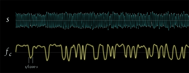
She first thought that it was interference from the engine, but when she isolated the left channel and amplified the sound ( selostus2.mp3 ), it immediately became clear that this was some mysterious digital signal!
Curiosity made the girl take up the puzzle . Judging by the spectrogram of the left channel, the device used binary frequency modulation (BFSK) when sounds of a certain frequency are assigned to values 0 and 1. In this case, the frequency varied between 1200 and 2200 Hz. She performed a demodulation of the signal by the low and high pass filter in an open-source program for audio processing SoX (Sound eXchange). The output was a digital stream of 1200 baud.
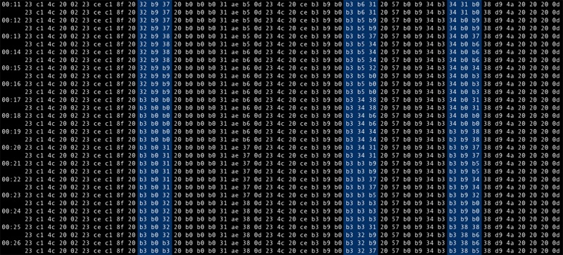
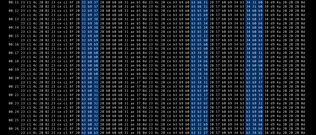
The stream consists of packets of 47 bytes, synchronized by start and end bits and separated by 0x80 byte. Most bits remain unchanged throughout the video, but three distinct groups are definitely changing. In the screenshot they are marked in blue. She began to wonder what could it be? Maybe telemetry data? Or information about the direction of shooting from a camcorder? Any timestamps per frame? Having analyzed three groups of data, Ryäsänen came to the conclusion that this is telemetry. If you discard the first four bits in each byte, then the remaining bytes can be represented as a pair of three-digit numbers in base-10 encoding. If you put them on the x and y coordinate axes
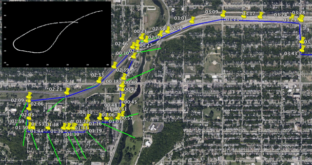
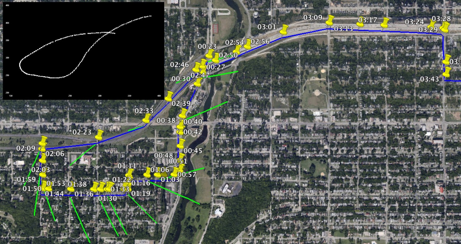
, you’ll get a graph very similar to the actual helicopter movement pattern. On the map, its approximate coordinates are shown in yellow, judging by the image from the video, and on the upper left is a graph with values from the mysterious data stream (the first few minutes of video recording are displayed). If you take a closer look, you will notice that 100 coordinate pairs correspond exactly to one minute of the video. Knowing the final coordinates of the helicopter (at the end it circled over the police station), we can attach the resulting trajectory to the Google Earth map. Thanks to the advice of knowledgeable comrades from the Internet, Oona Ryäsänen realized that it uses the 7-bit encoding of Bell 202 ASCII. After decoding, the values look like this:
These are full pairs of longitude and latitude accurate to the fourth digit (39.0386 ° N, 94.3420 ° W).
PS By the way, a year ago Oona Raisanen made a clear block diagram with a description of all the sounds that the dial-up modem emits when the connection is established.
PPS About the decoding of a digital signal from open broadcasts, she spoke in a report at the Chaos Communication Congress hacker conference in Hamburg on December 30, 2013 ( video ).
She first thought that it was interference from the engine, but when she isolated the left channel and amplified the sound ( selostus2.mp3 ), it immediately became clear that this was some mysterious digital signal!
Curiosity made the girl take up the puzzle . Judging by the spectrogram of the left channel, the device used binary frequency modulation (BFSK) when sounds of a certain frequency are assigned to values 0 and 1. In this case, the frequency varied between 1200 and 2200 Hz. She performed a demodulation of the signal by the low and high pass filter in an open-source program for audio processing SoX (Sound eXchange). The output was a digital stream of 1200 baud.
The stream consists of packets of 47 bytes, synchronized by start and end bits and separated by 0x80 byte. Most bits remain unchanged throughout the video, but three distinct groups are definitely changing. In the screenshot they are marked in blue. She began to wonder what could it be? Maybe telemetry data? Or information about the direction of shooting from a camcorder? Any timestamps per frame? Having analyzed three groups of data, Ryäsänen came to the conclusion that this is telemetry. If you discard the first four bits in each byte, then the remaining bytes can be represented as a pair of three-digit numbers in base-10 encoding. If you put them on the x and y coordinate axes
, you’ll get a graph very similar to the actual helicopter movement pattern. On the map, its approximate coordinates are shown in yellow, judging by the image from the video, and on the upper left is a graph with values from the mysterious data stream (the first few minutes of video recording are displayed). If you take a closer look, you will notice that 100 coordinate pairs correspond exactly to one minute of the video. Knowing the final coordinates of the helicopter (at the end it circled over the police station), we can attach the resulting trajectory to the Google Earth map. Thanks to the advice of knowledgeable comrades from the Internet, Oona Ryäsänen realized that it uses the 7-bit encoding of Bell 202 ASCII. After decoding, the values look like this:
#L N390386
W09434208YJ #L
N390386 W09434208YJ
#L N390384
W09434208YJ #L
N390384 W09434208YJ
#L N390381 W09434198YJ #L N390381 W09434198YJ #L N390379
These are full pairs of longitude and latitude accurate to the fourth digit (39.0386 ° N, 94.3420 ° W).
PS By the way, a year ago Oona Raisanen made a clear block diagram with a description of all the sounds that the dial-up modem emits when the connection is established.
PPS About the decoding of a digital signal from open broadcasts, she spoke in a report at the Chaos Communication Congress hacker conference in Hamburg on December 30, 2013 ( video ).