Majestic Sands: Desert Dunes, View from Space
 Today is Friday? Then why not be distracted by the popular science photo article about what occupies the fourth part of the land of our planet?
 Deserts are known as deserted and lifeless, but at the same time they are incredibly beautiful, especially when you look at them from above. Different types of sand, topography, wind and climate all together create a huge amount of landscapes. Wandering dunes form an infinite number of ever-changing figures.
The photos in this collection were taken by astronauts and satellites and captured the most beautiful, most memorable, huge desert areas of our planet.
Original article on wired.com
Translation of article on translated.by
Worked on the translation
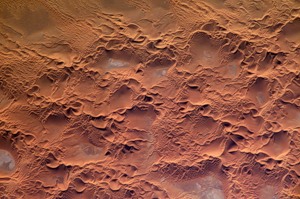
Algerian Sand Sea

View on Yandex.Photo (Photo by NASA) The
sandy sea (Erg) Issaouane extends over 39,000 sq. Km. in eastern Algeria. This sandy sea in the middle of the Sahara desert consists of three types of dunes. Mega dunes, also known as whale backs, formed over hundreds of thousands of years and reaching hundreds of kilometers in length. Mesoscale dunes form the apex of mega-dunes, their gradual displacement can be seen only after decades. Smaller dunes form on and around larger dunes. They take various forms under the influence of winds and are in constant motion.
In the photograph above taken by the ISS astronauts in 2005, the mesoscale dunes took the form of star dunes resembling a starfish and crescent dunes. In the photograph below, taken by the ISS astronauts in 2006, huge rounded shapes are mega-dunes. The smallest dunes look like wrinkles in the background of large dunes. View on Yandex.Photos (Photo by NASA)

Imperial California Dunes

View on Yandex.Photo (Photo by NASA)
Algodon dune field, located on the border between Mexico and Arizona with California, reaches a width of almost 10 km and stretches for 70 km. These dunes are best known as the dunes of the planet Tatooine in the Star Wars universe. On their open spaces is the official National Recreation Park, which is managed by the Bureau of Land Management. The only man-made structure among the dunes is the American Canal, which cuts its way through the dunes near their rise on the farmland of Mexico. It can be seen on the right in the photo. The photo was taken by astronauts from the ISS in 2005.
White Sands in New Mexico

View on Yandex.Photo (Photo by NASA) The
sands of the dunes of the “National Monument of White Sands” are particles of gypsum - an evaporite mineral that has accumulated as a result of the evaporation of large masses of water. At the place of these dunes, several hundred million years ago, a shallow sea dried up. A few thousand years ago a huge lake evaporated here. Such dunes are quite rare, because gypsum is usually easily dissolved in water and spreads by rivers. At this point, its particles were preserved due to the fact that there is no access to the sea from the pool where they are located. In turn, the water from the rivers flowing into this basin dried up, instead of washing out the gypsum.
Dunes in southern New Mexico cover an area of over 700 square kilometers. Almost half of the area is protected by the White Sands National Monument. This photo of the area was taken using the Advanced Land Imager aboard NASA Earth Observing-1 on June 27.
Rub Al Khali Desert (Empty Quarter) in Saudi Arabia

View on Yandex.Photo (Photo by NASA / USGS)
This aptly named desert is the largest sand sea in the world, covering an area of more than 580,000 square kilometers. The photo above shows part of it located in Saudi Arabia, but this sea also covers parts of Yemen, Oman and the UAE. View on Yandex.Photo (Photo by NASA / USGS) The gray and white spots between the pink sands are plains covered with dry salt. The temperature in Rub al-Khali (literally, can be translated as “empty quarter”) reaches 54 ° C. In such heat, only some species of plants, spiders and rodents that live here can survive. Sand covers one of the most oil-abundant areas in the world.

This photo was taken in 2001. using Enhanced Thematic Mapper Plus (ETM +) on NASA / USGS Landsat 7. Below you can take a look at a photograph of the dunes near. You can learn more about Rub al-Khali from this National Geographic video.
Tifernayn Dunes in Algeria

View on Yandex.Photo (Photo by NASA)
This part of the Sahara desert, located in the east of Algeria, is adjacent to the dark gray plateau Tinhert. Star dunes formed on top of the old large dunes under the influence of winds, and sedimentary rocks with salt gathered in small depressions between the dunes. Today, the climate is dry and hot, but river-carved valleys on the plateau border indicate a more humid climate in the past.
This photo was taken by astronauts from the ISS in August 2009.
Uniang Lakes, Chad

View on Yandex.Photo (NASA Photo)
These finger-shaped lakes are echoes of one large lake, which began to decline about 5.5 thousand years ago. The sand was driven by the wind, partially filling the lake basin and breaking the water into several separate lakes. Nine out of ten lakes are fresh, they draw water from an aquifer underground. Ancient pollen found among sedimentary rock in lakes showed that the area they occupied used to have a moderately tropical climate.
This photo was taken by astronauts of the ISS on November 14th.
The highest oldest dunes in the world

View on Yandex.Fotki
In the Namib desert, you can find dunes about three hundred meters high. They were carved by winds blowing along the Atlantic coast of Namibia. Namib Naukluft National Park pictured here is one of Africa's largest game parks. It found shelter for hyenas, jackals, geckos and other rare animals. In addition, this desert is considered one of the oldest in the world - the climate here was dry 55 million years ago. Today, its area has an average of only 6 cm of precipitation per year.
The photo above was taken in 2000 by the Landsat-7 satellite, which was controlled by NASA and USGS (US Geological Survey). The topographic image below was created by combining a photograph taken in 2002 with topological data obtained by ASTER equipment from the Terra satellite. In 2009, he celebrated his tenth anniversary. View on Yandex.Photos

Great Sand Dunes Colorado

View on Yandex.Photos
This collection of dunes perched near the Sangre de Cristo Mountains in southern Colorado was given the status of a national monument in 1932 and a national park in 2004. Every year, 300 thousand visitors visit it. Despite the fact that these dunes cover an area of slightly less than 80 square kilometers, they reach 230 m in height and are the highest dunes in the United States.
The slightly colored sand of the dunes was formed from sedimentary rock, which gradually weathered due to the adjacent mountains and settled in the lake. The lake periodically dried up, and the wind blew the rock from its bottom.
A photograph of the Great Sand Dunes National Park (above) was taken by the Ikonos sensor, aboard the GeoEye satellite, in 2005. Below is a photograph taken by the ISS astronauts in 2007.

View on Yandex.Photos
Saktoria: Ciliates that have lost their cilia

View on Yandex.Fotki
Smooth, almost sandless, flat-bottomed bowls bordered by huge dunes, which in turn are covered with small serrated dunes, give the central part of the Sahara desert the appearance of honeycombs.
The sandy sea of Murzuk in Libya contains numerous rows of such large dunes, referred to as the “draa”. The smaller dunes, which can be seen in the photograph below, consist of many star dunes, linear longitudinal dunes and curved transverse dunes. The weathered side of smaller dunes is smoother and flatter than the opposite side. This photo was taken by ISS astronauts in December 2008. View on Yandex.Photos

Air Lake in Australia

View on Yandex.Fotki
Heavy rains in early 2009 began to fill this huge bottom of a dried-up lake in this part of the Simpson desert in Queensland. In the photo above you can see the water flowing into the lake. It was made on May 9 by the Landsat-5 satellite. Plants and thousands of birds appear along with water. The photograph below, which was taken by the satellite on February 18, shows how dry this area remains most of the time in the year. View on Yandex.Photos

Naked breeds in the Sahara

View on Yandex.Photo The
sandy rivers, covered with dunes, bend around the exposed rocky rocks in this very arid and barren section of the Sahara in Libya. This photo was taken by the Terra satellite in 2002.
Scars of australia

View on Yandex.Photos
This part of the Simpson Desert in the Northern Territory of Australia is covered by a desert shrub that gives it a greenish tint and does not allow winds to move dunes. However, the fire that occurred here a year before this photograph was taken in 2002, burned part of the vegetation, exposing the sands under it.
A strange pattern in the sand must have been caused by a rotation of the direction of the winds 90 degrees during a fire. This photo was taken by the ISS astronauts.
Sandy rivers, covered by dunes, bend around exposed rocky rocks in this very arid and barren section of the Sahara in Libya. This photo was taken by the Terra satellite in 2002.
